Category:Barton, Cheshire
Aller à la navigation
Aller à la recherche
English: Barton is a village and civil parish in the unitary authority of Cheshire West and Chester and the ceremonial county of Cheshire, England. The village is located near the Welsh border, about twelve miles south of Chester, and only about eight miles east of Wrexham in Wales.
village britannique  | |||||
| Téléverser des médias | |||||
| Nature de l’élément | |||||
|---|---|---|---|---|---|
| Lieu | Cheshire West and Chester, Cheshire, Angleterre du Nord-Ouest, Angleterre | ||||
 | |||||
Média dans la catégorie « Barton, Cheshire »
Cette catégorie comprend 37 fichiers, dont les 37 ci-dessous.
-
 Approaching Barton on the A534 - geograph.org.uk - 2485855.jpg 640 × 480 ; 47 kio
-
 Barton - geograph.org.uk - 3981133.jpg 640 × 480 ; 275 kio
-
 Barton - Milepost.jpg 640 × 480 ; 110 kio
-
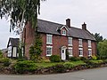
 Barton Farmhouse, Barton.jpg 640 × 480 ; 62 kio
-
 Barton Farmhouse.jpg 1 800 × 1 350 ; 1,98 Mio
-
 Barton Road (A534) towards Wrexham - geograph.org.uk - 6144605.jpg 800 × 600 ; 149 kio
-
 Barton Road in Barton Village - geograph.org.uk - 5226683.jpg 4 000 × 3 000 ; 3,03 Mio
-
 Barton village street - geograph.org.uk - 2249664.jpg 640 × 480 ; 63 kio
-
 Cattle off Mill Lane - geograph.org.uk - 6144529.jpg 640 × 480 ; 95 kio
-
 Cock of Barton Inn.jpg 640 × 480 ; 63 kio
-
 Disused farm track near Barton - geograph.org.uk - 6144592.jpg 800 × 600 ; 151 kio
-
 Field and woodland, Barton - geograph.org.uk - 6144599.jpg 800 × 600 ; 130 kio
-
 Field entrance off the Mill Lane - geograph.org.uk - 6144530.jpg 800 × 600 ; 159 kio
-
 Former farm building at Cock of Barton Inn.jpg 1 800 × 1 350 ; 1,3 Mio
-
 Grassland near Barton - geograph.org.uk - 6144594.jpg 800 × 600 ; 140 kio
-
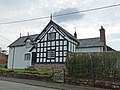
 Higher Farmhouse, Barton, Cheshire.jpg 1 800 × 1 350 ; 1,5 Mio
-
 House on Barton Road, Barton - geograph.org.uk - 6144596.jpg 800 × 599 ; 143 kio
-
 Lay-by on A534 Barton Road - geograph.org.uk - 3493823.jpg 2 048 × 1 536 ; 737 kio
-
 Mill Lane towards Coddington - geograph.org.uk - 6144531.jpg 800 × 600 ; 133 kio
-
 Millhey Farmhouse, Barton, Cheshire.jpg 4 000 × 3 000 ; 5,92 Mio
-
 Minor road towards Barton - geograph.org.uk - 6144595.jpg 800 × 600 ; 154 kio
-
 Minor road towards Stretton - geograph.org.uk - 6144602.jpg 800 × 600 ; 129 kio
-
 One Way Street, Barton - geograph.org.uk - 2829393.jpg 4 000 × 3 000 ; 2,05 Mio
-
 Ordnance Survey Flush Bracket S1195 - geograph.org.uk - 5226680.jpg 4 000 × 3 000 ; 4,38 Mio
-
 Ordnance Survey Flush Bracket S1196 - geograph.org.uk - 5226677.jpg 4 000 × 3 000 ; 2,91 Mio
-
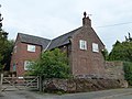 Rock Farmhouse.jpg 1 800 × 1 350 ; 416 kio
-
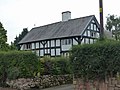 Rose Farm, Barton, Cheshire.jpg 1 800 × 1 350 ; 1,42 Mio
-
 Service station on Barton Road (A534) - geograph.org.uk - 6144604.jpg 800 × 527 ; 88 kio
-
 Sign for the Cock O'Barton - geograph.org.uk - 6144598.jpg 712 × 800 ; 83 kio
-
 Stocks in Barton, Cheshire.jpg 4 000 × 3 000 ; 4,99 Mio
-
 Stretton Lane - geograph.org.uk - 2360744.jpg 640 × 480 ; 50 kio
-
 The A534 (Barton Road) at Rowleyhill - geograph.org.uk - 3723425.jpg 5 184 × 3 456 ; 3,94 Mio
-
 The A534 (Barton Road), Barton - geograph.org.uk - 2829401.jpg 4 000 × 3 000 ; 2,66 Mio
-
 The A534 (Broxton Road) - geograph.org.uk - 2829438.jpg 4 000 × 3 000 ; 3,19 Mio
-
 The A534 Broxton Road - geograph.org.uk - 2485797.jpg 640 × 480 ; 59 kio
-
 The Cock O'Barton - geograph.org.uk - 3981128.jpg 640 × 480 ; 248 kio
-
 The Cock O'Barton - geograph.org.uk - 6144597.jpg 800 × 492 ; 85 kio


_towards_Wrexham_-_geograph.org.uk_-_6144605.jpg)


_-_geograph.org.uk_-_6144604.jpg)


_at_Rowleyhill_-_geograph.org.uk_-_3723425.jpg)
,_Barton_-_geograph.org.uk_-_2829401.jpg)
_-_geograph.org.uk_-_2829438.jpg)


