Category:Bezirk Hermagor
Jump to navigation
Jump to search
-

-
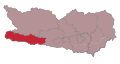
 1 Hermagor-Pressegger See, 2 Kirchbach, 3 Kötschach-Mauthen, 4 Dellach, 5 Gitschtal, 6 Lesachtal, 7 Sankt Stefan im Gailtal

district of Austria  | |||||
| Upload media | |||||
| Instance of | |||||
|---|---|---|---|---|---|
| Location | Carinthia, Austria | ||||
| Population |
| ||||
| Area |
| ||||
| Elevation above sea level |
| ||||
| official website | |||||
 | |||||
Subcategories
This category has the following 21 subcategories, out of 21 total.
Media in category "Bezirk Hermagor"
The following 32 files are in this category, out of 32 total.
-
 Abendstimmung Görtschach, Kärnten.jpg 1,280 × 757; 425 KB
-
 AvI Villacher Kreis.jpg 8,988 × 7,650; 26.12 MB
-
 Der Gailtaler, Ehren- und Zielscheibe, Hermagor, Kärnten.jpg 905 × 864; 508 KB
-
 Die Gailtaler, Ehren- und Zielscheibe, Hermagor, Kärnten.jpg 956 × 897; 551 KB
-

-
 Feistritz an der Gail, Musikschule Bildungszentrum, Bezirk Hermagor, Kärnten.jpg 1,500 × 724; 411 KB
-
 Gailtal Natur-Arena im Bezirk Hermagor, Kärnten.jpg 1,136 × 839; 522 KB
-

-
 Gemeinde- und Kulturzentrum St. Stefan im Gailtal, Kärnten.jpg 4,145 × 2,322; 1.89 MB
-
 Gemeinden im Bezirk Hermagor.png 850 × 620; 38 KB
-
 Gerichtsbezirk Hermagor.svg 397 × 212; 25 KB
-
 Görtschach 78, Wegkreuz Hermagor-Pressegger See, Karnische Region, Kärnten.jpg 2,016 × 1,436; 1.45 MB
-
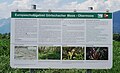 Görtschacher Moos - Obermoos, Feistritz im Gailtal, Bezirk Hermagor, Kärnten.jpg 1,240 × 754; 493 KB
-

-
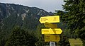 Karnische Alpen, Wegweiser Bezirk Hermagor, Kärnten.jpg 1,500 × 816; 667 KB
-
 Koze "ščekajo" (molzejo) na Dolški planini 1951 (2).jpg 3,018 × 1,889; 275 KB
-
 Koze "ščekajo" (molzejo) na Dolški planini 1951.jpg 3,056 × 1,874; 354 KB
-
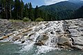
 Life Project Gail River, Carinthia, Austria.jpg 1,175 × 653; 534 KB
-
 Life Projekt des Gailflusses, Kärnten.jpg 1,500 × 799; 752 KB
-

-
 Mlinarjeva "fača" (stan) na Dolški planini 1951.jpg 1,681 × 2,168; 206 KB
-
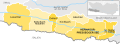 Municipalities Bezirk Hermagor.svg 995 × 364; 134 KB
-
 Naggler Alm Hütte - panoramio.jpg 3,264 × 2,448; 3.12 MB
-
 Občine v okraju Šmohor.png 1,800 × 800; 71 KB
-
 Panorama St. Paul im Gailtal, Bezirk Hermagor, Kärnten.jpg 1,500 × 948; 836 KB
-
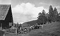 Pastir je prignal živino na Dovško planino 1951.jpg 3,058 × 1,853; 254 KB
-

-
 Presseggersee.jpg 5,503 × 1,222; 828 KB
-
 Siebenbrünn, Naturgarten Gemeinde Sankt Stefan im Gailtal, Kärnten.jpg 1,500 × 997; 1.37 MB
-
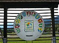
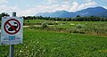
 Think global & act local - Denkt global & handelt lokal.jpg 1,195 × 889; 549 KB
-
-
 Štokova "fača" na Dolški planini 1951.jpg 2,836 × 1,920; 244 KB


_na_Dol%C5%A1ki_planini_1951_(2).jpg)
_na_Dol%C5%A1ki_planini_1951.jpg)


_na_Dol%C5%A1ki_planini_1951.jpg)


