Category:Biburg (Niederbayern)
Jump to navigation
Jump to search
municipality of Germany    | |||||
| Upload media | |||||
| Instance of |
| ||||
|---|---|---|---|---|---|
| Part of |
| ||||
| Location | Kelheim, Lower Bavaria, Bavaria, Germany | ||||
| Head of government |
| ||||
| Population |
| ||||
| Area |
| ||||
| Elevation above sea level |
| ||||
| Different from | |||||
| official website | |||||
 | |||||
Subcategories
This category has the following 4 subcategories, out of 4 total.
B
C
E
Media in category "Biburg (Niederbayern)"
The following 6 files are in this category, out of 6 total.
-
 Wappen von Biburg.svg 732 × 805; 102 KB
-
 Wappenbiburg.gif 197 × 219; 8 KB
-
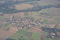 Aerial photograph of Biburg.jpg 3,648 × 2,432; 2.24 MB
-
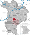
 Biburg - Lage im Landkreis.png 148 × 185; 25 KB
-
 Biburg in KEH.svg 576 × 664; 590 KB
-
 Biburg Lkr Kelheim Niederbayern Ortsansicht.JPG 2,039 × 1,035; 1.35 MB


