Category:Bildstockkopf Kirchplatz (Stettfeld)
Jump to navigation
Jump to search
This is the category of the Bavarian Baudenkmal (cultural heritage monument) with the ID D-6-74-201-2 (Wikidata)
|
| Object location | | View all coordinates using: OpenStreetMap |
|---|
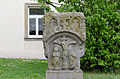
Deutsch: Bildstockkopf mit Darstellung der Kreuzigung und des hl. Christophorus, Maßwerkgliederungen, Sandstein spätgotisch, um 1430/50. Nähe Kirchplatz, im Kirchhof, Stettfeld, Landkreis Haßberge, Unterfranken, Deutschland
Media in category "Bildstockkopf Kirchplatz (Stettfeld)"
The following 3 files are in this category, out of 3 total.
-
 D-6-74-201-2 Friedhofskreuz Stettfeld.jpg 3,000 × 4,000; 2.63 MB
-
 Stettfeld, D-6-74-201-2, 001.jpg 4,928 × 3,264; 10.17 MB
-
 Stettfeld-Pfarrkirche-Bildstockkopf.jpg 5,616 × 3,744; 2.66 MB


