Category:Biogeographical maps
Aller à la navigation
Aller à la recherche
| ID WIKIDATA NON TROUVÉ ! Rechercher Biogeographical maps sur Wikidata | |
| Téléverser des médias |

Sous-catégories
Cette catégorie comprend 18 sous-catégories, dont les 18 ci-dessous.
!
*
A
B
- Biome maps (83 F)
D
- Degree days maps (8 F)
F
G
- Growing season maps (3 F)
H
M
R
S
- Biogeographical maps on stamps (28 F)
V
Média dans la catégorie « Biogeographical maps »
Cette catégorie comprend 77 fichiers, dont les 77 ci-dessous.
-
 A biological survey of Colorado (1911) (20380769085).jpg 3 712 × 3 064 ; 2,3 Mio
-
 Ecozone-Biocountry-Afrotropic-legend.svg 175 × 290 ; 106 kio
-

-

-

-
 Age and area; a study in geographical distribution and origin of species (1922) (14592173647).jpg 2 476 × 3 762 ; 1,17 Mio
-
 Age and area; a study in geographical distribution and origin of species (1922) (14798541433).jpg 3 840 × 2 444 ; 1,24 Mio
-
 Area Cladogram of Charis butterflies (Horizontal).png 1 774 × 1 677 ; 1,43 Mio
-
 Areas of Endemism (South America).png 1 319 × 1 586 ; 7,99 Mio
-
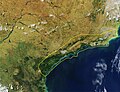
 Bahia coastal forests WWF Satelite.jpg 3 265 × 4 345 ; 4,52 Mio
-
 Bahia Mangroves WWF.jpg 2 580 × 3 440 ; 2,01 Mio
-
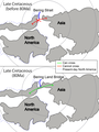
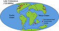
 Bering Land Bridge in Late Cretaceous.png 2 594 × 1 480 ; 320 kio
-
 Biogeografi sulawesi.png 2 046 × 2 986 ; 252 kio
-
 Biogeographical map of Indian Subcontinent001.jpg 7 000 × 7 589 ; 11,61 Mio
-
 Bulletin (1903) (20434218271).jpg 3 548 × 2 763 ; 1,55 Mio
-
-
 CA floristic province.png 210 × 380 ; 132 kio
-
 Chicken domestication and dispersal.svg 8 750 × 4 232 ; 267 kio
-
 Corredor Central Sul da Bahia - Espírito Santo.jpg 4 186 × 5 581 ; 5,73 Mio
-
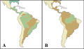
 Costello 2017 marine biogeography realms maps (figures 2a and 2b).jpg 678 × 677 ; 328 kio
-
 Cyanocorax chrysops map.png 420 × 530 ; 29 kio
-
 Cyanocorax yucatanicus map.png 400 × 400 ; 25 kio
-
 Elwes Biogeography 1873 645 PZSL.jpg 2 564 × 1 860 ; 3,76 Mio
-
 Entimus distribution.png 1 200 × 1 573 ; 86 kio
-
 G barretti distribution map (2015).png 610 × 552 ; 509 kio
-
 Gadow physical barriers.png 3 088 × 1 916 ; 3,85 Mio
-
 Gedibiomass gedi 2021 lrg.jpg 2 913 × 1 942 ; 2,74 Mio
-
 Gedibiomass gedi 2021.jpg 720 × 545 ; 459 kio
-
 Gediindig gedi 2021 lrg.jpg 2 913 × 1 942 ; 2,67 Mio
-
 Gediindig gedi 2021.jpg 720 × 545 ; 497 kio
-
 Geodispersal at Bering Land Bridge.png 2 074 × 2 771 ; 415 kio
-
 Geographical Distribution of Plants 1850 Alexander Keith Johnston.png 3 104 × 2 348 ; 8,6 Mio
-
 Geohistoria g.jpg 408 × 468 ; 61 kio
-
 Global Camelid Distribution and Migration.png 1 714 × 958 ; 6,27 Mio
-
 Great American Biotic Interchange examples.svg 900 × 1 052 ; 576 kio
-
 Hawaii speciation (Drosophila and Cyanea colonization).png 2 000 × 1 298 ; 9,91 Mio
-
 Hawaii speciation (Drosophila colonization).png 2 000 × 1 298 ; 1,52 Mio
-
 Ilha Grande Mangroves WWF.jpg 3 358 × 2 584 ; 1,74 Mio
-
 India to central Pacific locator map blank.svg 512 × 399 ; 1,35 Mio
-
 Isthmus of Panama (closure) - Speciation of marine organisms (w annot).png 946 × 1 151 ; 4,16 Mio
-
 Isthmus of Panama (closure) - Speciation of marine organisms (wo annot).png 946 × 1 151 ; 4,16 Mio
-
 Isthmus of Panama (closure) - Speciation of marine organisms (wo GABA).png 946 × 1 151 ; 4,16 Mio
-
 Karte Vegetation USA.jpg 790 × 555 ; 102 kio
-
 Life Zones Merriam.jpg 2 308 × 1 628 ; 3,35 Mio
-
 Major habitat type CAN.svg 1 304 × 1 265 ; 305 kio
-
 Marine-biogeographical-realm.png 961 × 481 ; 222 kio
-
 NIE 1905 Distribution of Animals - relevant terrestrial features.jpg 2 359 × 1 463 ; 555 kio
-

-
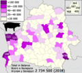 Number of pigs in Belarus — Пагалоўе свіней у Беларусі — Поголовье свиней в Беларуси (2018).png 2 000 × 1 785 ; 823 kio
-

-
 Parasite180080-Figure1 Map of sampling localities.png 2 002 × 1 019 ; 621 kio
-
 Parasite180080-Figure7 Cichlidogyrus kmentovae (Monogenea, Dactylogyridae).png 2 000 × 1 365 ; 440 kio
-
 PeerJ 2233 - Pseudorhabdosynochus sulamericanus - fig-7.png 1 335 × 1 207 ; 191 kio
-
 Pleistocene landscape types in North and South America.svg 516 × 300 ; 171 kio
-

-
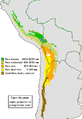 Puna.PNG 540 × 784 ; 134 kio
-
 R-froese-aquamaps-wshop-Oct-05.jpg 1 272 × 1 101 ; 254 kio
-
 Rio Piranhas & São Francisco Mangroves WWF.jpg 2 257 × 2 934 ; 1,43 Mio
-
 Sarmarutilus-range.jpg 2 079 × 2 480 ; 403 kio
-
 Serra do Mar Corredor.jpg 5 886 × 4 528 ; 6,91 Mio
-
 Short Faced Bear Range.png 347 × 167 ; 13 kio
-
 Temperate broadleaf and mixed forests.jpg 973 × 535 ; 50 kio
-
 The distribution of paraves in Early Cretaceous.png 3 209 × 1 812 ; 368 kio
-
 The distribution of paraves in Late Cretaceous.png 3 480 × 1 853 ; 406 kio
-
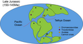 The distribution of paraves in Late Jurassic.png 3 311 × 1 779 ; 283 kio
-
 Vavilov-centers updated.jpg 1 000 × 614 ; 75 kio
-
 Wallace-line1.jpg 3 685 × 2 318 ; 3,6 Mio
-
 Woolly Mammoth Late Pleistocene Dymaxion Biogeographic Distribution.png 1 714 × 958 ; 6,27 Mio
-
 Ylistrum balloti (Bernardi, 1861) world distribution map.jpg 6 600 × 7 200 ; 6,24 Mio
-
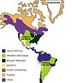
 Zonas biogeográficas Neártica y neotropical.png 1 348 × 1 452 ; 300 kio
-
 Біогеографічні регіони Європи .png 5 846 × 4 133 ; 2,71 Mio
-
 Біогеографічні регіони Європи.png 5 846 × 4 133 ; 2,06 Mio
-
 Біогеографічні регіони України .png 5 846 × 5 846 ; 1,61 Mio
-
 Біогеографічні регіони України- .png 5 846 × 5 846 ; 3,19 Mio
-
 Біогеографічні регіони України.png 5 846 × 5 846 ; 1,13 Mio
-
 Природный ареал подвида Erigeron acris subsp. brachycephalus.jpg 1 979 × 997 ; 92 kio
-
 Природный ареал подвида Erigeron acris subsp. droebachiensis.jpg 1 973 × 994 ; 95 kio
_(20380769085).jpg)

_(14591994339).jpg)
_(14592023738).jpg)
_(14592032358).jpg)
_(14592173647).jpg)
_(14798541433).jpg)
.png)
.png)


_(20434218271).jpg)
_(1871)_(20407557928).jpg)


.jpg)


.png)


.png)
.png)

_-_Speciation_of_marine_organisms_(w_annot).png)
_-_Speciation_of_marine_organisms_(wo_annot).png)
_-_Speciation_of_marine_organisms_(wo_GABA).png)


.png)
.png)
.png)

.png)


_world_distribution_map.jpg)


