Category:Bird's eye view maps of Rhode Island
Jump to navigation
Jump to search
Media in category "Bird's eye view maps of Rhode Island"
The following 19 files are in this category, out of 19 total.
-
 1905 bird's eye view streetcar map of southern New England.jpg 4,000 × 2,723; 3.08 MB
-
 1907 bird's eye view of trolley routes in New England.jpg 6,672 × 9,580; 17.18 MB
-
 1908 bird's eye view of trolley routes in New England.jpg 4,439 × 6,366; 10.27 MB
-
 Auburn, Rhode Island (2675913876).jpg 2,000 × 1,533; 2.49 MB
-
 Bird's eye view of Pawtucket & Central Falls, R.I. 1877. LOC 75696564.jpg 10,560 × 8,192; 17.41 MB
-
 Bird's eye view of Pawtucket, & Central Falls, R.I LCCN2004669575.jpg 10,350 × 7,665; 13.23 MB
-
 Birds eye or balloon view of Rocky Point. Narragansett Bay, R.I. LCCN2012649719.jpg 9,506 × 6,087; 11.19 MB
-
 Birds eye view of Pawtucket & Central Falls, R.I. 1877 (2675918490).jpg 2,000 × 1,561; 3.06 MB
-

-
 Crompton, Rhode Island (2675916004).jpg 2,000 × 1,551; 2.51 MB
-
 Lonsdale, Rhode Island, 1888. LOC 2008624024.jpg 10,666 × 8,687; 18.77 MB
-
 Narragansett Pier, Rhode Island (2675104357).jpg 2,000 × 1,573; 2.42 MB
-
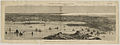 Newport, Rhode Island (2675917740).jpg 2,000 × 746; 1.13 MB
-
 Pawtuxet, Rhode Island (2675102497).jpg 2,000 × 1,471; 2.33 MB
-
 View of Warren, R.I. (2675923134).jpg 2,000 × 1,460; 2.63 MB
-
 View of Westerly, R.I. (2675108139).jpg 2,000 × 1,584; 2.66 MB
-
 Wakefield and Peace Dale, Rhode Island (2675922098).jpg 2,000 × 1,628; 2.71 MB
-
 Washington, Rhode Island (2675923986).jpg 2,000 × 1,406; 2.21 MB
-
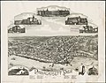
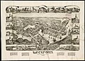 Wickford, Rhode Island - 1888 G3774.N54A3 1888O43.jpg 9,144 × 6,640; 8.89 MB


.jpg)


.jpg)
.jpg)
.jpg)

.jpg)
.jpg)
.jpg)
.jpg)
.jpg)
.jpg)

.jpg)