Category:Birling, Kent
Jump to navigation
Jump to search
English: Category:Villages in Kent
village and civil parish in the Tonbridge and Malling district of Kent, England  | |||||
| Upload media | |||||
| Instance of | |||||
|---|---|---|---|---|---|
| Location | Tonbridge and Malling, Kent, South East England, England | ||||
| Population |
| ||||
| Area |
| ||||
| Said to be the same as | Birling (Wikimedia duplicated page, civil parish) | ||||
 | |||||
Subcategories
This category has the following 3 subcategories, out of 3 total.
B
- Birling War Memorial, Kent (3 F)
O
- Oasts in Birling (5 F)
Media in category "Birling, Kent"
The following 200 files are in this category, out of 299 total.
(previous page) (next page)-
 1881 Occupational Structure, Birling.jpg 481 × 288; 26 KB
-
 19th Century Map of Birling, Kent.png 447 × 271; 315 KB
-
 A distant view of Birling Church - geograph.org.uk - 2331683.jpg 640 × 480; 129 KB
-
 A field of legumes - geograph.org.uk - 2611992.jpg 640 × 430; 64 KB
-
 A leguminous crop - geograph.org.uk - 2611986.jpg 640 × 430; 75 KB
-
 A leguminous field - geograph.org.uk - 2611996.jpg 640 × 430; 68 KB
-

-
 A228 Malling Road, Leybourne - geograph.org.uk - 2042610.jpg 2,048 × 1,536; 1.19 MB
-
 A228 Malling Road, Leybourne - geograph.org.uk - 2042612.jpg 2,048 × 1,536; 1.26 MB
-
 A228, Malling Rd - geograph.org.uk - 2592426.jpg 640 × 430; 60 KB
-
 A228, Malling Rd - geograph.org.uk - 2614507.jpg 640 × 430; 66 KB
-
 A228, Malling Rd - geograph.org.uk - 3530845.jpg 640 × 407; 52 KB
-
 A228, Malling Rd - geograph.org.uk - 3628085.jpg 640 × 430; 56 KB
-
 A228, Malling Rd looking south - geograph.org.uk - 2592428.jpg 640 × 430; 65 KB
-
 A228, northbound - geograph.org.uk - 3628080.jpg 640 × 430; 52 KB
-
 All Saints Church, Birling - geograph.org.uk - 2209552.jpg 1,152 × 770; 501 KB
-
 Annual flower festival at All Saints Church, Birling - geograph.org.uk - 4460974.jpg 4,000 × 3,000; 4.28 MB
-
 Annual flower festival at All Saints Church, Birling - geograph.org.uk - 4460979.jpg 3,000 × 4,000; 4.16 MB
-
 Annual flower festival at All Saints Church, Birling - geograph.org.uk - 4460982.jpg 4,000 × 3,000; 4.25 MB
-
 Annual flower festival at All Saints Church, Birling - geograph.org.uk - 4460984.jpg 4,000 × 3,000; 4.06 MB
-
 Annual flower festival at All Saints Church, Birling - geograph.org.uk - 4460987.jpg 4,000 × 3,000; 4.14 MB
-
 Annual flower festival at All Saints Church, Birling - geograph.org.uk - 4460989.jpg 4,000 × 3,000; 4.03 MB
-
 Bank Cottage, Birling - geograph.org.uk - 2593022.jpg 640 × 430; 68 KB
-
 Barn on Sandy Lane - geograph.org.uk - 2321270.jpg 640 × 427; 100 KB
-
 Barn, Coney Lodge Farm - geograph.org.uk - 2611965.jpg 640 × 430; 68 KB
-
 Barn, Coney Lodge Farm - geograph.org.uk - 2611967.jpg 640 × 430; 58 KB
-
 Below Holly Hill (1) - geograph.org.uk - 5087201.jpg 1,600 × 1,067; 680 KB
-
 Below Holly Hill (2) - geograph.org.uk - 5087202.jpg 1,600 × 1,067; 666 KB
-
 Birling 19th Century Map.png 473 × 298; 346 KB
-
 Birling Ashes - geograph.org.uk - 2592620.jpg 640 × 430; 66 KB
-
 Birling Ashes - geograph.org.uk - 2592621.jpg 640 × 430; 68 KB
-
 Birling Hill - geograph.org.uk - 2872474.jpg 640 × 480; 110 KB
-
 Birling Hill - geograph.org.uk - 3143060.jpg 640 × 430; 62 KB
-
 Birling Hill - geograph.org.uk - 3143067.jpg 640 × 430; 59 KB
-
 Birling Hill - geograph.org.uk - 3143074.jpg 640 × 430; 82 KB
-
 Birling Hill - geograph.org.uk - 3155884.jpg 640 × 430; 81 KB
-
 Birling Hill - geograph.org.uk - 3155889.jpg 640 × 430; 95 KB
-
 Birling Hill - geograph.org.uk - 3155895.jpg 640 × 430; 84 KB
-
 Birling Hill - geograph.org.uk - 3155904.jpg 640 × 430; 70 KB
-
 Birling Hill - geograph.org.uk - 3633530.jpg 640 × 430; 81 KB
-
 Birling Hill viewpoint - geograph.org.uk - 2209065.jpg 1,168 × 780; 312 KB
-
 Birling Hill viewpoint - geograph.org.uk - 2209073.jpg 1,153 × 783; 313 KB
-
 Birling Hill, Holly Hill junction - geograph.org.uk - 3633516.jpg 640 × 430; 114 KB
-
 Birling Hill, near Birling - geograph.org.uk - 5063047.jpg 3,264 × 2,448; 1.94 MB
-
 Birling Hill, near Birling - geograph.org.uk - 5063048.jpg 3,264 × 2,448; 1.78 MB
-
 Birling Lodge Farm - geograph.org.uk - 2612000.jpg 640 × 430; 75 KB
-
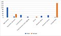 Birling Occupational Structure 1881.jpg 481 × 288; 24 KB
-
 Birling Park, Birling - geograph.org.uk - 5012950.jpg 3,264 × 2,448; 1.72 MB
-
 Birling Place Farm - geograph.org.uk - 2611977.jpg 640 × 430; 55 KB
-
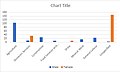
 Birling Population Time Series 1801-2011.jpg 480 × 288; 25 KB
-
 Birling Rd looking north - geograph.org.uk - 2592630.jpg 640 × 430; 65 KB
-
 Birling Rd looking south - geograph.org.uk - 2592629.jpg 640 × 430; 102 KB
-
 Birling Road, Birling - geograph.org.uk - 5012932.jpg 3,264 × 2,448; 1.98 MB
-
 Birling Village Sign - geograph.org.uk - 1165175.jpg 481 × 640; 63 KB
-
 Birling Village Sign - geograph.org.uk - 5012945.jpg 3,264 × 2,448; 1.83 MB
-
 Birling War Memorial - geograph.org.uk - 3063486.jpg 3,000 × 4,000; 4.04 MB
-
 Birling War Memorial and All Saints Church - geograph.org.uk - 4460992.jpg 3,000 × 4,000; 4.44 MB
-
 Bluebell in Whitehorse Wood - geograph.org.uk - 2872492.jpg 640 × 480; 111 KB
-
 Bridge over M20 north west of Leybourne - geograph.org.uk - 5632412.jpg 1,024 × 768; 134 KB
-
 Bridleway by Oast Park Golf Course - geograph.org.uk - 2614500.jpg 640 × 430; 99 KB
-
 Bridleway heading south - geograph.org.uk - 2614491.jpg 640 × 430; 130 KB
-
 Bridleway heading south - geograph.org.uk - 2614496.jpg 640 × 430; 125 KB
-
 Bridleway near Park Farm - geograph.org.uk - 4284202.jpg 4,000 × 3,000; 4.09 MB
-
 Bull Road - geograph.org.uk - 2321255.jpg 640 × 480; 97 KB
-
 Bull Road - geograph.org.uk - 4932288.jpg 4,608 × 3,456; 3.4 MB
-
 Bull Road, Birling - geograph.org.uk - 5012954.jpg 3,264 × 2,448; 1.86 MB
-
 Bull Road, Birling - geograph.org.uk - 5041713.jpg 2,304 × 1,728; 836 KB
-
 Bull Road, Birling - geograph.org.uk - 5041714.jpg 2,304 × 1,728; 833 KB
-
 Bull Road, Birling - geograph.org.uk - 5087147.jpg 1,600 × 1,067; 597 KB
-
 Castle Way at the junction of Leybourne Way - geograph.org.uk - 5155780.jpg 1,996 × 1,466; 1.6 MB
-
 Coney Lodge Farm - geograph.org.uk - 4284193.jpg 4,000 × 3,000; 3.84 MB
-
 Coppicing in Birling Ashes - geograph.org.uk - 2592613.jpg 640 × 430; 133 KB
-
 Cottage on Ryarsh Rd - geograph.org.uk - 2593029.jpg 640 × 430; 91 KB
-
 Cottage on Ryarsh Rd - geograph.org.uk - 2593040.jpg 640 × 406; 79 KB
-
 Country Lane leading to Birling - geograph.org.uk - 2209556.jpg 1,165 × 785; 522 KB
-
 Crossing a field of wheat - geograph.org.uk - 2611927.jpg 640 × 430; 67 KB
-

-
 Decrepitude, Holly Hill - geograph.org.uk - 2331390.jpg 640 × 428; 103 KB
-
 Dense vegetation, Birling Ashes - geograph.org.uk - 2592615.jpg 640 × 430; 122 KB
-
 Descending Birling Hill - geograph.org.uk - 3633523.jpg 640 × 430; 104 KB
-
 Descending Birling Hill - geograph.org.uk - 3633529.jpg 640 × 430; 117 KB
-
 Ditch and earthbank in a wheat field - geograph.org.uk - 2592875.jpg 640 × 430; 73 KB
-

-
 Driveway to Birling Lodge Farm - geograph.org.uk - 4460716.jpg 4,000 × 3,000; 4.23 MB
-
 Dwelling beside the Church in Birling - geograph.org.uk - 5087149.jpg 1,600 × 1,067; 657 KB
-
 Dyke Place - geograph.org.uk - 3633547.jpg 640 × 430; 67 KB
-
 Entering Ryarsh - geograph.org.uk - 2593042.jpg 640 × 430; 80 KB
-
 Fairway, Oast Park Golf Club - geograph.org.uk - 2592430.jpg 640 × 430; 40 KB
-
 Farmhouse, Coney Lodge Farm - geograph.org.uk - 2611966.jpg 640 × 430; 71 KB
-
 Farming landscape, Birling - geograph.org.uk - 2611976.jpg 640 × 430; 54 KB
-
 Farmland near Birling - geograph.org.uk - 2614369.jpg 640 × 430; 50 KB
-
 Farmland near Birling - geograph.org.uk - 2614486.jpg 640 × 430; 63 KB
-
 Farmland, Coney Lodge Farm - geograph.org.uk - 2611968.jpg 640 × 430; 67 KB
-
 Field below Whitehorse Wood - geograph.org.uk - 5087194.jpg 1,600 × 1,067; 632 KB
-
 Field beside Holly Hill Lodge - geograph.org.uk - 5087455.jpg 1,600 × 1,067; 560 KB
-
 Field edge below Birling Place Farm - geograph.org.uk - 4461064.jpg 4,000 × 3,000; 4.08 MB
-
 Field edge below Birling Place Farm - geograph.org.uk - 4461066.jpg 4,000 × 3,000; 4.26 MB
-
 Field edge near the Pilgrim's Way - geograph.org.uk - 2542092.jpg 4,000 × 3,000; 4.34 MB
-
 Field of Maize - geograph.org.uk - 2614446.jpg 640 × 430; 76 KB
-
 Field of Sheep - geograph.org.uk - 2321146.jpg 640 × 480; 105 KB
-
 Field to the West of Birling Place Farm - geograph.org.uk - 5087184.jpg 1,600 × 1,067; 609 KB
-
 Flooded Footpath - geograph.org.uk - 1165200.jpg 640 × 481; 101 KB
-
 Flooding on footpath - geograph.org.uk - 1165207.jpg 640 × 481; 88 KB
-
 Fog on the North Downs - geograph.org.uk - 2209548.jpg 1,135 × 746; 388 KB
-
 Footpath , Birling Ashes - geograph.org.uk - 2592463.jpg 640 × 430; 128 KB
-
 Footpath across a field of maize - geograph.org.uk - 2614466.jpg 640 × 430; 69 KB
-
 Footpath across a grassy meadow - geograph.org.uk - 2592452.jpg 640 × 430; 69 KB
-
 Footpath across a wheat field - geograph.org.uk - 2611925.jpg 640 × 430; 76 KB
-
 Footpath along a hedge line - geograph.org.uk - 2611971.jpg 640 × 430; 88 KB
-
 Footpath and legumes - geograph.org.uk - 2611989.jpg 640 × 430; 81 KB
-
 Footpath by a field of Legumes - geograph.org.uk - 2611987.jpg 640 × 430; 92 KB
-
 Footpath by the Tesco Depot - geograph.org.uk - 2516072.jpg 640 × 430; 139 KB
-
 Footpath entering Birling Ashes - geograph.org.uk - 2592454.jpg 640 × 430; 134 KB
-
 Footpath from Birling to Paddlesworth - geograph.org.uk - 3062394.jpg 3,000 × 4,000; 4.11 MB
-
 Footpath from Coney Lodge Farm - geograph.org.uk - 2611972.jpg 640 × 430; 110 KB
-
 Footpath heading North West from Birling Road - geograph.org.uk - 5087019.jpg 1,600 × 1,067; 621 KB
-
 Footpath heading south - geograph.org.uk - 2516070.jpg 640 × 430; 125 KB
-
 Footpath heading towards Holly Hill - geograph.org.uk - 5087190.jpg 1,600 × 1,067; 545 KB
-
 Footpath junction near Sandhole - geograph.org.uk - 2516071.jpg 640 × 430; 147 KB
-
 Footpath leading off Stangate Road - geograph.org.uk - 3063860.jpg 4,000 × 3,000; 4.22 MB
-
 Footpath near Birling Ashes - geograph.org.uk - 2592627.jpg 640 × 430; 75 KB
-
 Footpath near the golf course - geograph.org.uk - 2592437.jpg 640 × 430; 65 KB
-
 Footpath off Birling Hill - geograph.org.uk - 3143059.jpg 640 × 430; 65 KB
-
 Footpath off Birling Hill - geograph.org.uk - 3143070.jpg 640 × 430; 65 KB
-
 Footpath outside Birling Lodge Farm - geograph.org.uk - 5087178.jpg 1,600 × 1,067; 649 KB
-
 Footpath past Birling Lodge Farm - geograph.org.uk - 4461075.jpg 4,000 × 3,000; 4.35 MB
-
 Footpath sign near Stangate Road - geograph.org.uk - 2363618.jpg 4,000 × 3,000; 2.89 MB
-
 Footpath south from Birling - geograph.org.uk - 2592914.jpg 640 × 430; 71 KB
-
 Footpath throguh Whitehorse Wood - geograph.org.uk - 2872493.jpg 640 × 480; 145 KB
-
 Footpath through a field of wheat - geograph.org.uk - 2611930.jpg 640 × 430; 67 KB
-
 Footpath through a large wheat field - geograph.org.uk - 2592842.jpg 640 × 430; 62 KB
-
 Footpath through a large wheat field - geograph.org.uk - 2592903.jpg 640 × 430; 70 KB
-
 Footpath through Whitehorse Wood - geograph.org.uk - 2872487.jpg 640 × 480; 167 KB
-
 Footpath through Whitehorse Wood - geograph.org.uk - 2872489.jpg 640 × 480; 155 KB
-
 Footpath through Whitehorse Wood - geograph.org.uk - 2872490.jpg 640 × 480; 155 KB
-
 Footpath to All Saints Church, Birling - geograph.org.uk - 4461090.jpg 4,000 × 3,000; 4.21 MB
-
 Footpath to Birling - geograph.org.uk - 2592633.jpg 640 × 430; 54 KB
-
 Footpath to Birling - geograph.org.uk - 2592866.jpg 640 × 430; 71 KB
-
 Footpath to Birling - geograph.org.uk - 2592918.jpg 640 × 430; 96 KB
-
 Footpath to Birling - geograph.org.uk - 2611982.jpg 640 × 430; 75 KB
-
 Footpath to Birling - geograph.org.uk - 4461073.jpg 4,000 × 3,000; 4.09 MB
-
 Footpath to Birling Lodge Farm - geograph.org.uk - 4460721.jpg 4,000 × 3,000; 3.94 MB
-
 Footpath to Birling Place - geograph.org.uk - 2611985.jpg 640 × 430; 100 KB
-
 Footpath to Coney Lodge Farm - geograph.org.uk - 4284185.jpg 4,000 × 3,000; 4.43 MB
-
 Footpath to Paddlesworth - geograph.org.uk - 3062392.jpg 3,000 × 4,000; 4.14 MB
-
 Footpath to the North Downs Way - geograph.org.uk - 3063839.jpg 4,000 × 3,000; 4.07 MB
-
 Footpath towards Birling Place Farm - geograph.org.uk - 4461053.jpg 4,000 × 3,000; 4.27 MB
-
 Gabled Roofs - geograph.org.uk - 2321251.jpg 640 × 480; 106 KB
-
 Gate on the path to Birling Ashes - geograph.org.uk - 2592449.jpg 640 × 430; 139 KB
-
 Grassy meadow near Birling Ashes - geograph.org.uk - 2592451.jpg 640 × 430; 64 KB
-
 Harvel Lodge - geograph.org.uk - 2872501.jpg 640 × 480; 164 KB
-
 Heading for Birling Lodge Farm - geograph.org.uk - 5087174.jpg 1,600 × 1,067; 645 KB
-
 Hedge along a wheat field - geograph.org.uk - 2611974.jpg 640 × 430; 83 KB
-
 Hedge, path and legumes - geograph.org.uk - 2611995.jpg 640 × 430; 91 KB
-
 Holly Hill Road, Holly Hill - geograph.org.uk - 5062919.jpg 2,448 × 2,448; 1.56 MB
-
 Holly Hill, Birling Hill junction - geograph.org.uk - 3155879.jpg 640 × 430; 89 KB
-
 Home Farm House - geograph.org.uk - 1165190.jpg 640 × 481; 104 KB
-
 House by the church, Birling - geograph.org.uk - 2614438.jpg 640 × 430; 91 KB
-
 House on Masters Lane - geograph.org.uk - 2593007.jpg 640 × 430; 107 KB
-
 House on Ryarsh Road, Birling - geograph.org.uk - 5041716.jpg 2,304 × 1,728; 803 KB
-
 House on the corner of Masters Lane - geograph.org.uk - 2593024.jpg 640 × 430; 84 KB
-
 House on the corner, Sandy Lane - geograph.org.uk - 2331674.jpg 640 × 480; 113 KB
-
 House, Legge Lane - geograph.org.uk - 3633570.jpg 640 × 430; 93 KB
-
 J4, M20 - geograph.org.uk - 3628075.jpg 640 × 430; 37 KB
-

-
 Kissing gate near Birling - geograph.org.uk - 2611994.jpg 640 × 430; 106 KB
-
 Large house in Birling - geograph.org.uk - 2614378.jpg 640 × 430; 77 KB
-
 Large maize field - geograph.org.uk - 2614483.jpg 640 × 430; 93 KB
-
 Large wheat field near Birling - geograph.org.uk - 2592838.jpg 640 × 430; 72 KB
-
 Large wheat field near Birling - geograph.org.uk - 2592854.jpg 640 × 430; 66 KB
-
 Large wheat field near Birling - geograph.org.uk - 2592913.jpg 640 × 430; 75 KB
-
 Laundary Cottage - geograph.org.uk - 1160482.jpg 640 × 481; 122 KB
-
 Layby, A228, Malling Rd - geograph.org.uk - 3628086.jpg 640 × 430; 49 KB
-
 Legge Lane, near Birling - geograph.org.uk - 5012974.jpg 3,264 × 2,448; 2.3 MB
-
 Legumes north of Birling - geograph.org.uk - 2611990.jpg 640 × 430; 76 KB
-
 Line of trees near Sandhole - geograph.org.uk - 2516075.jpg 640 × 430; 53 KB
-
 Looking down Birling Hill - geograph.org.uk - 3063845.jpg 4,000 × 3,000; 4.05 MB
-
 Looking past Snodland Road - geograph.org.uk - 4460726.jpg 4,000 × 3,000; 4.05 MB
-
 Looking towards All Saints Church, Birling - geograph.org.uk - 4458843.jpg 4,000 × 3,000; 4.23 MB
-
 Looking towards All Saints Church, Birling - geograph.org.uk - 4461081.jpg 4,000 × 3,000; 4.09 MB
-
 Looking towards Birling Place Farm - geograph.org.uk - 4461057.jpg 4,000 × 3,000; 4.02 MB
-
 Looking towards Birling Place Farm - geograph.org.uk - 5087182.jpg 1,600 × 1,067; 708 KB
-
 Low voltage power line - geograph.org.uk - 2331367.jpg 640 × 480; 95 KB
-
 Lych gate, Birling - geograph.org.uk - 2614392.jpg 640 × 430; 116 KB
-
 M20 - geograph.org.uk - 4569679.jpg 640 × 426; 51 KB
-
 M20 - junction 4 ahead - geograph.org.uk - 2977230.jpg 640 × 480; 106 KB
-
 M20 Motorway, Birling Wood - geograph.org.uk - 3708781.jpg 640 × 480; 244 KB
-
 M20, Birling Road Bridge - geograph.org.uk - 3628055.jpg 640 × 430; 42 KB
-
 M20, eastbound - geograph.org.uk - 3628052.jpg 640 × 430; 40 KB
-
 M20, Flyover at Junction 4 - geograph.org.uk - 3708787.jpg 640 × 427; 228 KB
-
 M20, J4 slip road - geograph.org.uk - 3628060.jpg 640 × 430; 41 KB
-
 Maize and woodland - geograph.org.uk - 2614478.jpg 640 × 430; 77 KB
-
 Masters Lane - geograph.org.uk - 2593010.jpg 640 × 430; 125 KB
-
 Meadow, Birling Lodge Farm - geograph.org.uk - 2611998.jpg 640 × 430; 58 KB
-
 Nevill Bull sign - geograph.org.uk - 2321247.jpg 480 × 640; 80 KB
-
 Nevill Bull, Birling - geograph.org.uk - 1620852.jpg 640 × 480; 68 KB
-
 Nevill Bull, Birling - geograph.org.uk - 2321244.jpg 640 × 480; 88 KB
-
 Nevill Bull, Birling - geograph.org.uk - 2614427.jpg 640 × 430; 87 KB
-
 Nevill Bull, Birling - geograph.org.uk - 5012959.jpg 2,448 × 3,264; 1.82 MB
-
 North Downs Way below Holly Hill - geograph.org.uk - 5087199.jpg 1,600 × 1,067; 710 KB


_-_geograph.org.uk_-_5087201.jpg)
_-_geograph.org.uk_-_5087202.jpg)


