Category:Bittern Line
Jump to navigation
Jump to search
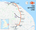
Norfolk railway line   | |||||
| Upload media | |||||
| Instance of | |||||
|---|---|---|---|---|---|
| Part of |
| ||||
| Location | Norfolk, East of England, England | ||||
| Owned by | |||||
| Operator | |||||
| Date of official opening |
| ||||
| |||||
Subcategories
This category has the following 15 subcategories, out of 15 total.
A
B
- Bridges on the Bittern Line (58 F)
C
G
H
L
N
- North Walsham railway station (19 F)
R
- Roughton Road railway station (11 F)
S
- Salhouse railway station (6 F)
- Signs on the Bittern Line (1 F)
W
- West Runton railway station (24 F)
- Worstead railway station (15 F)
Media in category "Bittern Line"
The following 119 files are in this category, out of 119 total.
-
 -1998-08-07 Train at Roughton Road Station, Cromer.jpg 682 × 1,024; 1,017 KB
-
 -2019-09-20 Looking eastwards along the line from Cromer beach signal box, Cromer.JPG 5,152 × 3,864; 7.63 MB
-
 -2019-09-20 Looking towards Cromer station, Bittern Line.JPG 3,864 × 5,152; 7.7 MB
-
 -2019-09-20 Looking westwards along the line from Cromer beach signal box, Cromer.JPG 3,864 × 5,152; 9.96 MB
-
 -2019-09-20 Train passing by Cromer beach signal box, Cromer.JPG 5,152 × 3,864; 7.75 MB
-
 -2020-01-01 Railway bridge, Newstead's Lane, Cromer (1).jpg 1,024 × 768; 173 KB
-
 -2020-01-01 Railway bridge, Newstead's Lane, Cromer.jpg 1,024 × 684; 210 KB
-
 -2020-02-12 The approach to Cromer Station on the Bittern Line.JPG 5,152 × 3,864; 7.13 MB
-
 -2021-02-07 Pond Road Railway Bridge, Antingham, Norfolk.JPG 5,152 × 3,864; 4.4 MB
-

-
 -2021-03-02 Railway Bridge, Cherry Tree Lane, North Walsham (1).jpg 1,024 × 768; 169 KB
-
 -2021-03-02 Railway Bridge, Cherry Tree Lane, North Walsham.jpg 1,024 × 768; 181 KB
-
 -2021-03-13 Access steps to the Bittern Line from Hall Road, Northrepps.JPG 5,152 × 3,864; 6.24 MB
-
 -2021-06-07 Access ramp to Gunton Station, Thorpe Market, Norfolk (1).JPG 5,152 × 3,864; 6.61 MB
-
 -2021-06-07 Access ramp to Gunton Station, Thorpe Market, Norfolk (2).JPG 5,152 × 3,864; 6.05 MB
-
 -2021-06-07 Bittern Line railway bridge, Thorpe Market.JPG 5,152 × 3,864; 7.76 MB
-

-
-
 -2021-06-07 Car park, Gunton Railway Station, Norfolk.JPG 5,152 × 3,864; 7.07 MB
-
 -2021-06-07 Gunton railway station (Bittern Line), Thorpe Market, Norfolk (1).JPG 5,152 × 3,864; 6.51 MB
-
 -2021-06-07 Gunton railway station (Bittern Line), Thorpe Market, Norfolk (2).JPG 3,864 × 5,152; 7.08 MB
-
 -2021-06-07 Gunton railway station (Bittern Line), Thorpe Market, Norfolk (3).JPG 3,864 × 5,152; 6.43 MB
-
 -2021-06-07 Gunton railway station, Thorpe Market, Norfolk.JPG 5,152 × 3,864; 6.07 MB
-
 -2021-06-07 Platform on Gunton railway station, Thorpe Market, Norfolk.JPG 5,152 × 3,864; 6.96 MB
-
 -2021-06-08 Amazon Hub, Gunton Railway Station, Thorpe Market, Norfolk.JPG 5,152 × 3,864; 6.18 MB
-
 -2021-07-02 Railway bridge over a footpath, North Walsham.jpg 1,024 × 768; 234 KB
-
 -2021-07-02 Railway Bridge, Aylsham Road, North Walsham.jpg 1,024 × 768; 222 KB
-
 -2021-07-02 View from under the Railway Bridge, Aylsham Road, North Walsham.jpg 1,024 × 768; 177 KB
-
 -2021-07-02 View of the Railway Bridge, Aylsham Road, North Walsham.jpg 1,024 × 768; 261 KB
-
 -2021-07-13 Bypass Flyover and Rail Bridge, Aylsham Road, North Walsham.jpg 1,024 × 768; 175 KB
-
 -2021-09-09 Railway Bridge, Newstead's Lane, East Runton.JPG 5,152 × 3,864; 7.26 MB
-
 -2021-11-02 Railway bridge, Thorpe Road, Southrepps.JPG 4,902 × 3,515; 4.97 MB
-

-
 -2021-12-14 Gunton railway station, Norfolk, England (1).JPG 5,152 × 3,864; 7.43 MB
-
 -2021-12-14 Gunton railway station, Norfolk, England (2).JPG 5,152 × 3,864; 7.36 MB
-
 -2021-12-14 Gunton railway station, Norfolk, England.JPG 5,152 × 3,864; 2.69 MB
-
 -2021-12-14 Station sign, Gunton railway station, Thorpe Market, Norfolk.JPG 5,152 × 3,864; 8.44 MB
-
 -2022-01-27 Bittern Line railway bridge, East Runton, Norfolk.JPG 5,152 × 3,864; 8.03 MB
-
 -2022-01-27 Bittern Line, East Runton, Norfolk (1).JPG 3,864 × 5,152; 7.44 MB
-
 -2022-01-27 Bittern Line, East Runton, Norfolk (2).JPG 3,864 × 5,152; 7.05 MB
-
 -2022-03-03 Railway bridge, Elderton Lane, Antingham, Norfolk.JPG 5,152 × 3,864; 5.98 MB
-
 -2022-04-12 Cromer railway Station, Holt Road, Cromer.JPG 5,152 × 3,864; 5.55 MB
-
 -2022-04-12 Waiting room, Cromer railway Station, Holt Road, Cromer.JPG 5,152 × 3,864; 6.44 MB
-

-
 -2022-07-14 Bittern line railway bridge, Northrepps, Norfolk.JPG 4,920 × 2,929; 3.78 MB
-
 2018-05-24 Bittern Line track, Nelson road, Beeston Regis.JPG 5,152 × 3,864; 7.01 MB
-
 2018-05-31 Bittern Line bridge, Northrepps, Cromer (2).JPG 5,152 × 3,864; 5.99 MB
-
 2018-09-13 Hall Road Railway Bridge over the Bittern Line, Southrepps.JPG 5,152 × 3,864; 6.59 MB
-
 2018-09-13 Hall road railway bridge, Parish of Southrepps.JPG 5,152 × 3,864; 7.47 MB
-
 2018-09-13 Looking south along Hall Road, Southrepps.JPG 5,152 × 3,864; 7.16 MB
-
 2018-09-13 Looking south east along the Bittern Line, Southrepps.JPG 5,152 × 3,864; 7.06 MB
-
 -2018-09-29 Bittern Line railway bridge, Gunton station.JPG 5,152 × 3,864; 7.71 MB
-
 -2018-10-09 Bittern Line bridge, Pond Road, Antingham, Norfolk (1).JPG 5,152 × 3,864; 7.6 MB
-
 -2018-10-09 Bittern Line bridge, Pond Road, Antingham, Norfolk (2).JPG 3,864 × 5,152; 5.88 MB
-

-
 -2018-11-01 Railway bridge, Hall road, Cromer, Norfolk (1).JPG 5,152 × 3,864; 8.41 MB
-
 -2018-11-01 Railway bridge, Hall road, Cromer, Norfolk (2).JPG 5,152 × 3,864; 8.22 MB
-
 -2018-12-30 Bittern Line viewed fro the Footpath to Northrepps from Crossdale Street (1).JPG 3,864 × 5,152; 4.12 MB
-
 -2018-12-30 Bittern Line viewed fro the Footpath to Northrepps from Crossdale Street (2).JPG 5,152 × 3,864; 5.28 MB
-
 -2018-12-30 Bittern Line viewed fro the Footpath to Northrepps from Crossdale Street (3).JPG 5,152 × 3,864; 4.99 MB
-

-
 Approach to Worstead railway bridge - geograph.org.uk - 458321.jpg 640 × 480; 77 KB
-

-
 Beeston Hill, 29 February 2016.JPG 5,152 × 3,864; 8.67 MB
-
 Bittern Line - geograph.org.uk - 2582585.jpg 800 × 531; 150 KB
-
 Bitten Line Track re-newal Sunday 17 2006 (1).JPG 2,560 × 1,920; 1.13 MB
-
 Bittern Line, 29 February 2016 (1).JPG 5,152 × 3,864; 7.18 MB
-
 Bittern Line, 29 February 2016 (2).JPG 5,152 × 3,864; 7.57 MB
-
 Bittern Line.png 2,192 × 1,823; 2.22 MB
-
 Black cat - geograph.org.uk - 1084728.jpg 589 × 640; 177 KB
-
 Bretts Hill Railway Bridge, Thorpe Road - geograph.org.uk - 2364404.jpg 3,072 × 2,304; 1.48 MB
-
 Bridge at Gunton station - geograph.org.uk - 1635128.jpg 640 × 428; 106 KB
-
 Bridge over railway line - geograph.org.uk - 1087104.jpg 640 × 480; 114 KB
-
 Church lane Footpath Beeston Regis.JPG 3,000 × 4,000; 3.77 MB
-
 The North Norfolk Railway 01.jpg 4,000 × 3,000; 1.04 MB
-
 The North Norfolk Railway 02.jpg 4,000 × 3,000; 981 KB
-
 Crossing the railway on the Weavers Way near Cromer - geograph.org.uk - 3833799.jpg 1,600 × 1,200; 537 KB
-
 Disused Railwaymans Bothy Beeston Regis 23 July 2014 (1).jpg 4,000 × 3,000; 4.25 MB
-
 Disused Railwaymans Hut Beeston Regis 23 July 2014 (2).JPG 4,000 × 3,000; 4.22 MB
-
 Entering North Walsham - geograph.org.uk - 1634720.jpg 640 × 428; 107 KB
-

-
 Gated level crossing - geograph.org.uk - 458428.jpg 640 × 480; 84 KB
-
 Gated level crossing - geograph.org.uk - 494257.jpg 640 × 480; 152 KB
-
 Gated level crossing - geograph.org.uk - 516644.jpg 640 × 480; 61 KB
-
 Heading down the line to Cromer - geograph.org.uk - 510140.jpg 640 × 480; 93 KB
-
 Heading up the line to Norwich - geograph.org.uk - 510142.jpg 480 × 640; 104 KB
-
 Level crossing, Antingham - geograph.org.uk - 529048.jpg 640 × 480; 76 KB
-
 Line to Cromer - geograph.org.uk - 3920560.jpg 640 × 430; 78 KB
-
 Line to Sheringham - geograph.org.uk - 3920559.jpg 640 × 430; 77 KB
-

-

-
 MandGN remains - geograph.org.uk - 1417426.jpg 640 × 480; 103 KB
-
-
 Railway Bridge - geograph.org.uk - 1257287.jpg 640 × 480; 72 KB
-
 Railway bridge - geograph.org.uk - 516627.jpg 640 × 480; 74 KB
-
 Railway bridge across New Road - geograph.org.uk - 510157.jpg 480 × 640; 73 KB
-

-
 Railway bridge over New Road - geograph.org.uk - 3135864.jpg 640 × 480; 108 KB
-

-
 Railway Track, Cromer - geograph.org.uk - 1523511.jpg 640 × 480; 114 KB
-
 Railway Track, Mill Lane, East Runton - geograph.org.uk - 1523502.jpg 640 × 480; 104 KB
-
 Railway tracks - geograph.org.uk - 510181.jpg 480 × 640; 95 KB
-
 Railway, Sheringham - geograph.org.uk - 4425643.jpg 1,000 × 486; 532 KB
-
 Looking eastwards from Sheringham Station - geograph.org.uk - 2309996.jpg 2,304 × 3,072; 2.62 MB
-
 Railway line from Sheringham to Cromer - geograph.org.uk - 2310071.jpg 3,072 × 2,304; 2.86 MB
-
 Railway towards Cromer - geograph.org.uk - 2310050.jpg 3,072 × 2,304; 2.93 MB
-
 Sheringham Station - geograph.org.uk - 2310058.jpg 3,072 × 2,304; 2.96 MB
-

-
 Stop, Look, Listen^ The line is clear - geograph.org.uk - 512151.jpg 480 × 640; 113 KB
-
 Straight to Cromer (via Roughton Road) - geograph.org.uk - 521290.jpg 640 × 480; 176 KB
-
 The Bittern Line - geograph.org.uk - 2582596.jpg 800 × 531; 118 KB
-
 The Bittern Line by Thorpe End - geograph.org.uk - 415630.jpg 640 × 494; 106 KB
-
 Towards Cromer and Sheringham - geograph.org.uk - 448677.jpg 640 × 480; 118 KB
-
 Towards Norwich - geograph.org.uk - 448680.jpg 640 × 480; 134 KB
-
 Unmanned level crossing, Beeston Regis - geograph.org.uk - 2737985.jpg 4,320 × 3,240; 4.9 MB
-
 Viaduct over the road to Felbrigg - geograph.org.uk - 560393.jpg 478 × 640; 202 KB
-

-
 -2022-01-06 Railway bridge over Westwick Road, Worstead, Norfolk.JPG 5,152 × 3,864; 7.3 MB
-
 -2022-01-06 Railway level crossing, Station Road, Worstead, Norfolk.JPG 5,152 × 3,864; 5.45 MB


.jpg)


.jpg)


.JPG)
.JPG)

.JPG)
.JPG)

,_Thorpe_Market,_Norfolk_(1).JPG)
,_Thorpe_Market,_Norfolk_(2).JPG)
,_Thorpe_Market,_Norfolk_(3).JPG)


_train,_Gunton_railway_station,_Thorpe_Market,_Norfolk.JPG)
.JPG)
.JPG)


.JPG)
.JPG)


.JPG)


.JPG)
.JPG)

.JPG)
.JPG)
.JPG)
.JPG)
.JPG)
.JPG)


.JPG)
.JPG)
.JPG)


.jpg)
.JPG)


_-_geograph.org.uk_-_521290.jpg)


