Category:Blankartshof (Ahrweiler)
Jump to navigation
Jump to search
| Object location | | View all coordinates using: OpenStreetMap |
|---|
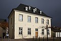
building in Bad Neuenahr-Ahrweiler, Germany | |||||
| Upload media | |||||
| Instance of | |||||
|---|---|---|---|---|---|
| Location | Bad Neuenahr-Ahrweiler, Ahrweiler, Rhineland-Palatinate, Germany | ||||
| Heritage designation | |||||
 | |||||
Media in category "Blankartshof (Ahrweiler)"
The following 9 files are in this category, out of 9 total.
-
 Ahrweiler Blankartshof 01.JPG 3,587 × 2,393; 6.18 MB
-
 Ahrweiler Blankartshof 02.JPG 3,646 × 2,521; 7.42 MB
-
 Ahrweiler Blankartshof 03.JPG 2,209 × 3,274; 6.04 MB
-
 Ahrweiler Blankartshof Plakette.jpg 2,592 × 1,456; 1.15 MB
-
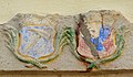 Ahrweiler Blankartshof Wappen 176.JPG 2,835 × 1,656; 961 KB
-
 Ahrweiler, Blankartshof 1-20160426-001.jpg 6,016 × 4,016; 14.41 MB
-
 Ahrweiler, Blankartshof 1-20160426-002.jpg 6,016 × 4,016; 11.58 MB
-
 Ahrweiler, Blankartshof 1-20160426-003.jpg 6,016 × 4,016; 12.53 MB
-
 Blankartshof 01.jpg 1,400 × 1,116; 409 KB