Category:Boerenstraat 11, Gorinchem
Jump to navigation
Jump to search
| Object location | | View all coordinates using: OpenStreetMap |
|---|
house in Gorinchem, Netherlands  | |||||
| Upload media | |||||
| Instance of | |||||
|---|---|---|---|---|---|
| Location | Gorinchem, South Holland, Netherlands | ||||
| Street address |
| ||||
| Located on street |
| ||||
| Heritage designation |
| ||||
 | |||||
|
This is a category about rijksmonument number 16557
|
| Address |
|
Media in category "Boerenstraat 11, Gorinchem"
The following 14 files are in this category, out of 14 total.
-
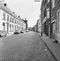
 Boerenstraat naar het noorden - Gorinchem - 20080146 - RCE.jpg 1,195 × 1,200; 332 KB
-
 Boerenstraat naar het zuiden - Gorinchem - 20080147 - RCE.jpg 1,192 × 1,200; 319 KB
-
 Exterieur VOORGEVEL, RECHTER ZIJGEVEL - Gorinchem - 20276956 - RCE.jpg 1,200 × 954; 225 KB
-
 Gevel - Gorinchem - 20080713 - RCE.jpg 963 × 1,200; 219 KB
-
 Gorinchem - rijksmonument 16557 - Boerenstraat 11 20120311.jpg 651 × 800; 191 KB
-
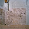
 Interieur detail opname muurschildering - Gorinchem - 20324306 - RCE.jpg 1,194 × 1,200; 334 KB
-
 Interieur detail opname muurschildering - Gorinchem - 20324307 - RCE.jpg 1,194 × 1,200; 265 KB
-
 Interieur detail opname muurschildering - Gorinchem - 20324308 - RCE.jpg 1,195 × 1,200; 282 KB
-
 Interieur detail opname muurschildering - Gorinchem - 20324309 - RCE.jpg 1,194 × 1,200; 472 KB
-
 Interieur overzicht borstwering met muurschilderingen - Gorinchem - 20324305 - RCE.jpg 1,187 × 1,200; 195 KB
-
 Overzicht - Gorinchem - 20080703 - RCE.jpg 1,200 × 804; 191 KB
-
 Overzicht - Gorinchem - 20080711 - RCE.jpg 1,200 × 966; 277 KB
-
 Overzicht - Gorinchem - 20390066 - RCE.jpg 1,200 × 956; 260 KB
-
 Woonhuis - Gorinchem - 20080710 - RCE.jpg 804 × 1,200; 204 KB


