Category:Bollwerk Lichtenberg
Jump to navigation
Jump to search
| Object location | | View all coordinates using: OpenStreetMap |
|---|
Battery Tower in Fischbachtal-Lichtenberg  | |||||
| Upload media | |||||
| Instance of | |||||
|---|---|---|---|---|---|
| Location | Lichtenberg, Fischbachtal, Darmstadt-Dieburg, Darmstadt Government Region, Hesse, Germany | ||||
| Heritage designation | |||||
| Height |
| ||||
 | |||||
This is the category of the Hessian Kulturdenkmal (cultural monument) with the ID Unknown? (Wikidata)
|
Media in category "Bollwerk Lichtenberg"
The following 15 files are in this category, out of 15 total.
-
 Bild von Lichtenberg 1904.jpg 870 × 474; 234 KB
-
 Bollwerk (Lichtenberg)-1.JPG 4,320 × 3,240; 5.87 MB
-
 Bollwerk (Lichtenberg)-Eingang.JPG 3,240 × 4,320; 5.49 MB
-
 Bollwerk (Lichtenberg)-Pechnase.JPG 4,320 × 3,240; 5.64 MB
-
 Bollwerk (Lichtenberg)-Schild.JPG 3,240 × 4,320; 5.42 MB
-
 Bollwerk (Schloss Lichtenbach).jpg 4,000 × 3,000; 1.69 MB
-
 Der Weg zum Bollwerk..jpg 2,144 × 1,424; 1.25 MB
-
 Fischbachtal Lichtenberg Kirchweg 2.jpg 4,608 × 2,592; 5.61 MB
-
 Lichtenberg (Merian).jpg 828 × 1,232; 254 KB
-
 Lichtenberg Bollwerk Detail 300 SAM 0740 20200501.jpg 2,425 × 3,233; 1.84 MB
-
 Lichtenberg Bollwerk SW Scharte SAM 0776 20200501.jpg 3,264 × 2,448; 2.32 MB
-
 Lichtenberg Bollwerk von Schloss 290 SAM 0745 20200501.jpg 3,725 × 2,095; 2.25 MB
-
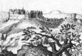 Lichtenberg Fischbachtal De Merian Hassiae.jpg 800 × 547; 113 KB
-
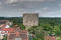 Schloss Lichtenberg Bollwerk.jpg 4,272 × 2,848; 990 KB
-
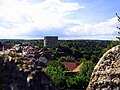
 Schloss Lichtenberg Landschaft.jpg 1,600 × 1,064; 1.14 MB

-1.JPG)
-Eingang.JPG)
-Pechnase.JPG)
-Schild.JPG)
.jpg)


.jpg)


