Category:Bow Brickhill
Vai alla navigazione
Vai alla ricerca
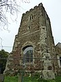
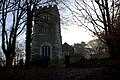
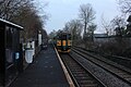
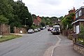
English: Bow Brickhill is a village and civil parish in the Borough of Milton Keynes, Buckinghamshire, England. It is just a short distance south east of Milton Keynes itself.
villaggio e parrocchia civile dell'Inghilterra  | |||||
| Carica un file multimediale | |||||
| Istanza di | |||||
|---|---|---|---|---|---|
| Luogo | Milton Keynes, Buckinghamshire, Sud Est dell'Inghilterra, Inghilterra | ||||
 | |||||
Sottocategorie
Questa categoria contiene le 3 sottocategorie indicate di seguito, su un totale di 3.
A
B
- Bow Brickhill War Memorial (1 F)
File nella categoria "Bow Brickhill"
Questa categoria contiene 103 file, indicati di seguito, su un totale di 103.
-
 All Saints , Bow Brickhill- church gates - geograph.org.uk - 2600140.jpg 640 × 480; 132 KB
-
 All Saints , Bow Brickhill- church porch - geograph.org.uk - 2600131.jpg 480 × 640; 105 KB
-
-

-

-

-

-
 All Saints church door - geograph.org.uk - 5231322.jpg 5 202 × 3 465; 6,12 MB
-
 All Saints church sign - geograph.org.uk - 5231318.jpg 5 202 × 3 465; 3,53 MB
-
 All Saints church through the trees - geograph.org.uk - 5231316.jpg 5 202 × 3 465; 4,04 MB
-
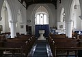
 All Saints church, Bow Brickhill - geograph.org.uk - 5231329.jpg 5 202 × 3 465; 3,88 MB
-
 Approaching All Saints , Bow Brickhill - geograph.org.uk - 2600108.jpg 640 × 480; 134 KB
-
 Around Bow Brickhill - geograph.org.uk - 5133410.jpg 480 × 640; 75 KB
-
 Around Bow Brickhill Heath - geograph.org.uk - 5148018.jpg 640 × 480; 105 KB
-
 Back Wood, Bow Brickhill - geograph.org.uk - 438902.jpg 640 × 480; 80 KB
-
 Borough of Milton Keynes , The A5 - geograph.org.uk - 5733034.jpg 6 000 × 4 000; 5,57 MB
-
 Bow Brickhill - geograph.org.uk - 3743227.jpg 640 × 478; 69 KB
-
 Bow Brickhill - geograph.org.uk - 4492267.jpg 2 560 × 1 920; 3,32 MB
-
 Bow Brickhill Animal Feeds - geograph.org.uk - 209024.jpg 640 × 480; 146 KB
-
 Bow Brickhill church - geograph.org.uk - 3312165.jpg 640 × 480; 101 KB
-
 Bow Brickhill Church - geograph.org.uk - 5133360.jpg 480 × 640; 61 KB
-
 Bow Brickhill level crossing - geograph.org.uk - 5024103.jpg 1 600 × 1 066; 355 KB
-

-
 Bow Brickhill Primary School - geograph.org.uk - 4102718.jpg 800 × 581; 151 KB
-
 Bow Brickhill railway station - geograph.org.uk - 3386218.jpg 1 024 × 768; 206 KB
-
 Bow Brickhill station - geograph.org.uk - 3312162.jpg 1 600 × 1 200; 463 KB
-
 Bow Brickhill station - geograph.org.uk - 5230950.jpg 5 184 × 3 456; 6,88 MB
-
 Bow Brickhill station - geograph.org.uk - 5230951.jpg 4 825 × 3 175; 3,49 MB
-
 Bow Brickhill, aerial - geograph.org.uk - 3478699.jpg 683 × 1 024; 247 KB
-
 BowBrickhill01.JPG 2 304 × 1 536; 825 KB
-

-
 Bridleway to Old Farm Park - geograph.org.uk - 2339405.jpg 640 × 480; 114 KB
-
 Bridleway towards Woburn golf club - geograph.org.uk - 5231339.jpg 4 442 × 3 175; 4,19 MB
-

-
 Christmas sheep, Bow Brickhill - geograph.org.uk - 5230962.jpg 5 202 × 3 465; 2,72 MB
-
 Church Road and phone mast - geograph.org.uk - 2935207.jpg 480 × 640; 112 KB
-
 Church Road, Bow Brickhill - geograph.org.uk - 1564926.jpg 640 × 480; 151 KB
-
 Church Road, Bow Brickhill - geograph.org.uk - 5231290.jpg 5 184 × 3 456; 6,78 MB
-
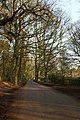 Country road ESE of Bow Brickhill - geograph.org.uk - 1243.jpg 425 × 640; 76 KB
-
 Covered reservoir - geograph.org.uk - 2935255.jpg 640 × 427; 101 KB
-
 Cut tree on Church Road - geograph.org.uk - 5231336.jpg 4 332 × 2 835; 2,23 MB
-

-
 Down Church Road, Bow Brickhill - geograph.org.uk - 5231307.jpg 5 184 × 3 456; 7,65 MB
-
 Downs Covert - geograph.org.uk - 5133400.jpg 480 × 640; 117 KB
-
 Downs Covert - geograph.org.uk - 5133403.jpg 480 × 640; 105 KB
-
 Drakewell Road, Bow Brickhill - geograph.org.uk - 5231302.jpg 5 184 × 3 456; 7,38 MB
-
 Drive which is also a public footpath - geograph.org.uk - 2593988.jpg 480 × 640; 112 KB
-
 Fallen tree in Bow Brickhill Park - geograph.org.uk - 2953014.jpg 2 560 × 1 920; 984 KB
-

-
 Footpath to All Saints Church, Bow Brickhill - geograph.org.uk - 5231306.jpg 5 184 × 3 456; 6,99 MB
-
 Fruit scone at church - geograph.org.uk - 2741009.jpg 1 024 × 768; 198 KB
-

-
 Gate on the church path - geograph.org.uk - 5231309.jpg 5 202 × 3 465; 5,13 MB
-
 Gate on the path - geograph.org.uk - 5231326.jpg 4 387 × 3 164; 4,82 MB
-
 Houses at Bow Brickhill - geograph.org.uk - 5230965.jpg 5 184 × 3 456; 5,11 MB
-
 In Back Wood - geograph.org.uk - 5133374.jpg 480 × 640; 93 KB
-
 In Back Wood - geograph.org.uk - 5133376.jpg 480 × 640; 98 KB
-
 In Back Wood - geograph.org.uk - 5133396.jpg 640 × 480; 89 KB
-
 In Back Wood - geograph.org.uk - 5133397.jpg 480 × 640; 91 KB
-
 In Brown's Wood - geograph.org.uk - 5130952.jpg 480 × 640; 121 KB
-
-
 London End - geograph.org.uk - 5133407.jpg 480 × 640; 104 KB
-

-
 Milton Keynes , Brickhill Road - geograph.org.uk - 5732836.jpg 6 000 × 4 000; 5,81 MB
-
 Milton Keynes , Brickhill Road - geograph.org.uk - 5732839.jpg 6 000 × 4 000; 7,7 MB
-
 Milton Keynes , Brickhill Road - geograph.org.uk - 5732841.jpg 6 000 × 4 000; 6,66 MB
-
 Milton Keynes , The A5 - geograph.org.uk - 5732834.jpg 6 000 × 4 000; 5,7 MB
-
 Milton Keynes , The A5 - geograph.org.uk - 5733033.jpg 6 000 × 4 000; 5,91 MB
-
 Motto, Bow Brickhill Primary School - geograph.org.uk - 4102757.jpg 800 × 596; 194 KB
-
 Old house on Station Road - geograph.org.uk - 2935193.jpg 640 × 427; 69 KB
-
 Ordnance Survey Trig Pillar S7203 - geograph.org.uk - 3255734.jpg 3 264 × 2 448; 2,13 MB
-

-

-
 Postbox in Church Lane - geograph.org.uk - 2593984.jpg 640 × 480; 106 KB
-
 Private road into Bow Brickhill park - geograph.org.uk - 5231332.jpg 4 825 × 3 076; 4,32 MB
-
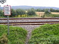 Public footpath crossing a railway - geograph.org.uk - 209270.jpg 640 × 480; 176 KB
-
 Pump in Church Road, Bow Brickhill - geograph.org.uk - 5231297.jpg 5 202 × 3 465; 7,37 MB
-
 Sign on the A5, Fenny Stratford - geograph.org.uk - 6176393.jpg 1 920 × 1 280; 958 KB
-
 Station Road, Bow Brickhill - geograph.org.uk - 5230963.jpg 5 184 × 3 456; 4,72 MB
-
 The A5 near Fenny Stratford - geograph.org.uk - 6163513.jpg 1 872 × 1 204; 923 KB
-
 The Heath - geograph.org.uk - 5231346.jpg 4 983 × 3 000; 2,88 MB
-

-
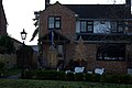
 The Wheatsheaf pub sign, Bow Brickhill - geograph.org.uk - 5230958.jpg 5 202 × 3 465; 2,17 MB
-
 The Wheatsheaf Public House - geograph.org.uk - 217541.jpg 640 × 480; 125 KB
-
 Towards Bow Brickhill church - geograph.org.uk - 5133357.jpg 640 × 480; 71 KB
-
 Towards Bow Brickhill Road - geograph.org.uk - 5130933.jpg 640 × 480; 77 KB
-
 Towards Bow Brickhill Road - geograph.org.uk - 5130936.jpg 640 × 480; 58 KB
-
 Towards Bow Brickhill Road - geograph.org.uk - 5130939.jpg 480 × 640; 46 KB
-
 Towards Bow Brickhill Road - geograph.org.uk - 5130944.jpg 640 × 480; 123 KB
-
 Towards Bow Brickhill Road - geograph.org.uk - 5130947.jpg 480 × 640; 117 KB
-
 Towards Bow Brickhill Road - geograph.org.uk - 5130950.jpg 640 × 480; 105 KB
-
 Towards Bow Brickhill Road - geograph.org.uk - 5130953.jpg 640 × 480; 99 KB
-
 Towards Downs Covert - geograph.org.uk - 5133369.jpg 480 × 640; 94 KB
-
 Towards the church in Bow Brickhill - geograph.org.uk - 5133414.jpg 640 × 480; 95 KB
-
 Towards Weeks Covert - geograph.org.uk - 5133362.jpg 480 × 640; 75 KB
-
 Towards Weeks Covert - geograph.org.uk - 5133366.jpg 480 × 640; 73 KB
-
 Trees on the edge of Woburn golf course - geograph.org.uk - 5231343.jpg 4 600 × 3 317; 4,49 MB
-
 War Memorial, Bow Brickhill - geograph.org.uk - 2593979.jpg 640 × 480; 81 KB
-
 War Memorial, Bow Brickhill - geograph.org.uk - 5231283.jpg 4 808 × 3 290; 3,26 MB
-
 Wheatsheaf pub. Bow Brickhill - geograph.org.uk - 5230959.jpg 5 184 × 3 456; 5,09 MB
-
 Woburn - Marquess' Course - geograph.org.uk - 673597.jpg 640 × 480; 74 KB
-
 Woburn Golf Club - geograph.org.uk - 343070.jpg 640 × 438; 49 KB
-
 Woburn Golf Club geograph-4549064-by-M-J-Richardson.jpg 3 264 × 2 448; 4,45 MB


_-_geograph.org.uk_-_2600113.jpg)


