Category:Boxlohe 18 (Schwabach)
Jump to navigation
Jump to search
| Object location | | View all coordinates using: OpenStreetMap |
|---|
| Upload media | |||||
| Instance of | |||||
|---|---|---|---|---|---|
| Location | Schwabach, Middle Franconia, Bavaria, Germany | ||||
| Street address |
| ||||
| Heritage designation | |||||
 | |||||
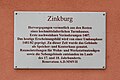
This is the category of the Bavarian Baudenkmal (cultural heritage monument) with the ID D-5-65-000-29 (Wikidata)
|
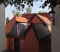
Deutsch: Sogenannte Zinkburg. Um Innenhof gruppiertes Ackerbürger- und Klingenschmied-Anwesen, Wohnhaus mit Schopfwalmdach, wohl 17. Jahrhundert.
Media in category "Boxlohe 18 (Schwabach)"
The following 8 files are in this category, out of 8 total.
-
 Boxlohe 18 Schwabach 20190626 001.jpg 6,016 × 4,016; 12.09 MB
-
 Schwabach - Boxlohe 18 - 1.jpg 4,698 × 3,132; 6.61 MB
-
 Schwabach - Boxlohe 18 - Detail 1.jpg 4,818 × 3,212; 7.36 MB
-
 Schwabach - Boxlohe 18 - Zinkburg 2.jpg 3,574 × 3,054; 3.49 MB
-
 Schwabach - Boxlohe 18 - Zinkburg.jpg 3,604 × 3,078; 3.17 MB
-
 Schwabach, Boxlohe 18-20160815-001.jpg 5,996 × 4,003; 10.75 MB
-
 Schwabach, Boxlohe 18-20160815-002.jpg 5,996 × 4,003; 13.12 MB
-
 Schwabach, Boxlohe 18-20160815-003.jpg 5,996 × 4,003; 11.35 MB


