Category:Breudijk 22, Harmelen
Jump to navigation
Jump to search
| Object location | | View all coordinates using: OpenStreetMap |
|---|
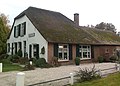
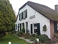
farmhouse in Woerden, Netherlands  | |||||
| Upload media | |||||
| Instance of | |||||
|---|---|---|---|---|---|
| Location | Harmelen, Utrecht, Netherlands | ||||
| Street address |
| ||||
| Located on street | |||||
| Heritage designation |
| ||||
 | |||||
|
This is a category about rijksmonument number 20811
|
| Address |
|
Media in category "Breudijk 22, Harmelen"
The following 11 files are in this category, out of 11 total.
-
 20811-breudijk22-0401.jpg 2,048 × 1,536; 633 KB
-
 20811-breudijk22-0402.jpg 1,852 × 1,325; 600 KB
-
 20811-breudijk22-0403.jpg 2,048 × 1,536; 687 KB
-
 Linkerzijde - Harmelen - 20102483 - RCE.jpg 1,189 × 1,200; 272 KB
-
 Rechterzijde - Harmelen - 20102484 - RCE.jpg 1,192 × 1,200; 377 KB
-
 Voor- en linker zijgevel - Harmelen - 20102487 - RCE.jpg 1,200 × 800; 224 KB
-
 Voor- en rechter zijgevel - Harmelen - 20102485 - RCE.jpg 1,200 × 800; 219 KB
-
 Voor- en zijgevel nr. KV 4; RDMZ, Zeist - Harmelen - 20466667 - RCE.jpg 1,200 × 900; 158 KB
-
 Voorgevel - Harmelen - 20102486 - RCE.jpg 1,200 × 804; 254 KB
-
 Voorgevel nr. KV 5; RDMZ, Zeist - Harmelen - 20466666 - RCE.jpg 1,200 × 900; 166 KB
-
 Zij- en voorgevel nr. KV 6; RDMZ, Zeist - Harmelen - 20466665 - RCE.jpg 1,200 × 900; 144 KB


