Category:Breudijk 51, Harmelen
Jump to navigation
Jump to search
| Object location | | View all coordinates using: OpenStreetMap |
|---|
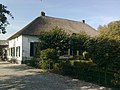
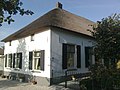
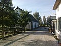
farmhouse in Woerden, Netherlands  | |||||
| Upload media | |||||
| Instance of | |||||
|---|---|---|---|---|---|
| Location | Harmelen, Utrecht, Netherlands | ||||
| Street address |
| ||||
| Located on street | |||||
| Heritage designation |
| ||||
 | |||||
Nederlands: Landzicht
|
This is a category about rijksmonument number 20812
|
|
This is a category about rijksmonument number 20813
|
| Address |
|
Media in category "Breudijk 51, Harmelen"
The following 10 files are in this category, out of 10 total.
-
 20812-Photo0301.jpg 2,048 × 1,536; 754 KB
-
 20812-Photo0302.jpg 2,048 × 1,536; 631 KB
-
 20813-Photo0304.jpg 2,048 × 1,536; 862 KB
-
 20813-Photo0305.jpg 2,048 × 1,536; 791 KB
-
 Gevel - Harmelen - 20102503 - RCE.jpg 1,190 × 1,200; 338 KB
-
 Landzicht" voorgevel - Harmelen - 20102504 - RCE.jpg 1,200 × 800; 218 KB
-
 Voorgevel - Harmelen - 20466659 - RCE.jpg 1,200 × 900; 150 KB
-
 Voorgevel nr. KV 1; RDMZ, Zeist - Harmelen - 20466660 - RCE.jpg 1,200 × 900; 153 KB
-
 Zijgevel woongedeelte - Harmelen - 20466657 - RCE.jpg 1,200 × 900; 171 KB
-
 Zijgevel woongedeelte - Harmelen - 20466658 - RCE.jpg 1,200 × 900; 121 KB


