Category:Brink 23, Deventer
Jump to navigation
Jump to search
| Object location | | View all coordinates using: OpenStreetMap |
|---|
 | |||||
| Upload media | |||||
| Instance of |
| ||||
|---|---|---|---|---|---|
| Location | Deventer, Overijssel, Netherlands | ||||
| Street address |
| ||||
| Heritage designation |
| ||||
 | |||||
|
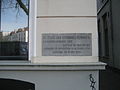
This is a category about rijksmonument number 12490
|
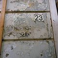
| Address |
|
Media in category "Brink 23, Deventer"
The following 20 files are in this category, out of 20 total.
-
 Achtergevel - Deventer - 20055616 - RCE.jpg 1,200 × 786; 200 KB
-
 Achterzijde - Deventer - 20055615 - RCE.jpg 967 × 1,200; 244 KB
-
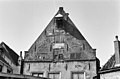
 Brink 23 Deventer.jpg 1,712 × 2,560; 1.28 MB
-
 Deventer20.JPG 2,816 × 2,112; 3.02 MB
-
 Exterieur OVERZICHT - Deventer - 20261299 - RCE.jpg 1,200 × 789; 155 KB
-
 Exterieur SPOREN BUITENAFWERKING - Deventer - 20299649 - RCE.jpg 1,196 × 1,200; 318 KB
-
 Exterieur VOORGEVEL TIJDENS RESTAURATIE - Deventer - 20267054 - RCE.jpg 1,192 × 1,200; 372 KB
-
 Exterieur VOORGEVEL TIJDENS RESTAURATIE - Deventer - 20267055 - RCE.jpg 1,189 × 1,200; 321 KB
-
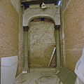
 INTERIEUR, GANG, BALKOPSCHRIFTEN - Deventer - 20299652 - RCE.jpg 1,198 × 1,200; 267 KB
-
 INTERIEUR, HAL, KOLOM MAANSTEEG, KLEURENTRAPJE - Deventer - 20299650 - RCE.jpg 1,198 × 1,200; 300 KB
-
 INTERIEUR, HAL, KOLOM, KLEURENTRAPJE - Deventer - 20299651 - RCE.jpg 1,200 × 1,200; 256 KB
-
 INTERIEUR, HAL, KOLOMMEN, KLEURENTRAPJES - Deventer - 20299653 - RCE.jpg 1,198 × 1,200; 296 KB
-
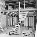 INTERIEUR, OVERZICHT HOUTEN SPILTRAP - Deventer - 20297341 - RCE.jpg 1,188 × 1,200; 322 KB
-
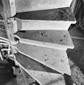 INTERIEUR, OVERZICHT HOUTEN SPILTRAP - Deventer - 20297342 - RCE.jpg 1,190 × 1,200; 415 KB
-
 INTERIEUR, OVERZICHT HOUTEN SPILTRAP - Deventer - 20297343 - RCE.jpg 1,200 × 1,200; 281 KB
-
 INTERIEUR, OVERZICHT HOUTEN SPILTRAP - Deventer - 20297344 - RCE.jpg 1,197 × 1,200; 376 KB
-
 INTERIEUR, OVERZICHT HOUTEN SPILTRAP - Deventer - 20297345 - RCE.jpg 1,195 × 1,200; 384 KB
-
 INTERIEUR, OVERZICHT HOUTEN SPILTRAP - Deventer - 20297346 - RCE.jpg 1,190 × 1,200; 402 KB
-
 Voorgevels - Deventer - 20055614 - RCE.jpg 1,200 × 806; 195 KB
-


