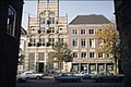
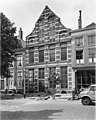
Category:Brink 69, Deventer
Jump to navigation
Jump to search
| Object location | | View all coordinates using: OpenStreetMap |
|---|
house in Deventer, Netherlands  | |||||
| Upload media | |||||
| Instance of | |||||
|---|---|---|---|---|---|
| Location | Deventer, Overijssel, Netherlands | ||||
| Street address |
| ||||
| Heritage designation |
| ||||
 | |||||
Nederlands: Groote of Heilige Geestgasthuis
|
This is a category about rijksmonument number 12518
|
| Address |
|
Media in category "Brink 69, Deventer"
The following 8 files are in this category, out of 8 total.
-
 Brink 69 Deventer.jpg 1,712 × 2,560; 1.65 MB
-
 Exterieur VOORGEVELS - Deventer - 20261308 - RCE.jpg 2,137 × 1,429; 959 KB
-
 Groote of Heilige Geestgasthuis - Deventer - 20055697 - RCE.jpg 959 × 1,200; 262 KB
-
 Overzicht voorgevel - Deventer - 20350859 - RCE.jpg 955 × 1,200; 387 KB
-
 Voorgevel - Deventer - 20055698 - RCE.jpg 808 × 1,200; 201 KB
-
 Voorgevel - Deventer - 20055699 - RCE.jpg 958 × 1,200; 168 KB
-
 Voorgevel - Deventer - 20055700 - RCE.jpg 958 × 1,200; 138 KB
-
 Voorgevel - Deventer - 20055701 - RCE.jpg 958 × 1,200; 186 KB


