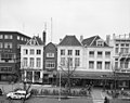
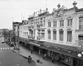
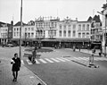
Category:Brink 97, Deventer
Jump to navigation
Jump to search
| Object location | | View all coordinates using: OpenStreetMap |
|---|
 | |||||
| Upload media | |||||
| Instance of |
| ||||
|---|---|---|---|---|---|
| Location | Deventer, Overijssel, Netherlands | ||||
| Street address |
| ||||
| Heritage designation |
| ||||
 | |||||
|
This is a category about rijksmonument number 12539
|
| Address |
|
Media in category "Brink 97, Deventer"
The following 11 files are in this category, out of 11 total.
-
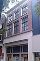 Brink 97 Deventer.jpg 1,712 × 2,560; 996 KB
-
 Gevels - Deventer - 20055794 - RCE.jpg 1,200 × 954; 222 KB
-
 Overzicht - Deventer - 20055562 - RCE.jpg 1,200 × 802; 184 KB
-
 Overzicht - Deventer - 20055791 - RCE.jpg 1,200 × 954; 221 KB
-
 Overzicht - Deventer - 20055798 - RCE.jpg 1,200 × 958; 238 KB
-
 Overzicht - Deventer - 20055802 - RCE.jpg 1,192 × 1,200; 271 KB
-
 Overzicht gevels - Deventer - 20055792 - RCE.jpg 1,200 × 954; 242 KB
-

-
 Voorgevel V & D - Deventer - 20055804 - RCE.jpg 1,200 × 1,197; 348 KB
-
 Voorgevels - Deventer - 20055790 - RCE.jpg 803 × 1,200; 197 KB
-
 Voorgevels - Deventer - 20055795 - RCE.jpg 1,200 × 956; 212 KB


_centraal_gelegen_(_nummer_100_)_-_Deventer_-_20384192_-_RCE.jpg)


