Category:Brothertoft
Aller à la navigation
Aller à la recherche
localité britannique du comté anglais de Lincolnshire  | |||||
| Téléverser des médias | |||||
| Nature de l’élément |
| ||||
|---|---|---|---|---|---|
| Lieu | Holland Fen with Brothertoft, district de Boston, Lincolnshire, Midlands de l'Est, Angleterre | ||||
 | |||||
Sous-catégories
Cette catégorie comprend seulement la sous-catégorie ci-dessous.
B
Média dans la catégorie « Brothertoft »
Cette catégorie comprend 20 fichiers, dont les 20 ci-dessous.
-
 Across the fields at Brothertoft - geograph.org.uk - 1899222.jpg 1 600 × 1 200 ; 395 kio
-
 Big sky over Great Fen - geograph.org.uk - 365943.jpg 640 × 480 ; 64 kio
-
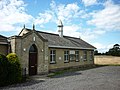 Brothertoft village hall (geograph 2575830).jpg 800 × 600 ; 280 kio
-
 Brothertoft Village Hall - geograph.org.uk - 3678276.jpg 640 × 480 ; 62 kio
-
 Crop field near Brothertoft - geograph.org.uk - 3678280.jpg 640 × 480 ; 99 kio
-
 Entering Brothertoft, Lincolnshire - geograph.org.uk - 2575820.jpg 800 × 600 ; 214 kio
-
 Entrance to Brothertoft - geograph.org.uk - 5187572.jpg 640 × 480 ; 57 kio
-
 Ferry Lane, Brothertoft - geograph.org.uk - 1898044.jpg 1 600 × 1 156 ; 304 kio
-
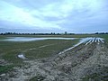 Fields by the North Forty Foot Drain - geograph.org.uk - 365967.jpg 640 × 480 ; 82 kio
-
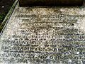 Geegrave1 (2).jpg 2 048 × 1 536 ; 659 kio
-
 Ha-Ha between Brothertoft churchyard and Brothertoft Hall park - geograph.org.uk - 1895167.jpg 1 600 × 1 200 ; 637 kio
-
 HedgehogBridgeSchool.jpg 645 × 467 ; 99 kio
-
 Highland Cattle near Brothertoft Church - geograph.org.uk - 427907.jpg 640 × 480 ; 97 kio
-
 North Forty Foot Drain from Benton's Bridge - geograph.org.uk - 1474845.jpg 640 × 480 ; 80 kio
-
 Pea field - geograph.org.uk - 460876.jpg 640 × 480 ; 65 kio
-
 Punchbowl Lane - geograph.org.uk - 235294.jpg 640 × 480 ; 88 kio
-
 The Bridge by Dovecote Farm - geograph.org.uk - 365981.jpg 640 × 480 ; 113 kio
-
 Beech Hedge - geograph.org.uk - 375341.jpg 640 × 484 ; 46 kio
-
 Deserted Footpath - geograph.org.uk - 459264.jpg 640 × 480 ; 60 kio
-


.jpg)


.jpg)


