Category:Burnley Embankment
Jump to navigation
Jump to search
Main category: Leeds and Liverpool Canal

waterway in the United Kingdom | |||||
| Upload media | |||||
 | |||||
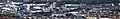
English: The Burnley Embankment in Burnley, Lancashire carries the Leeds and Liverpool Canal through the town centre, up to 60 feet (18 m) above the surrounding land. At 1,256 yards (0.714 mi; 1.148 km) long, it is the largest canal embankment in Great Britain.
Media in category "Burnley Embankment"
The following 19 files are in this category, out of 19 total.
-
 Burnley - Pentridge Mill from canal (geograph 2637959).jpg 1,600 × 1,200; 464 KB
-
 Burnley Bus Station - geograph.org.uk - 326848.jpg 640 × 429; 109 KB
-
 Burnley Embankment - geograph.org.uk - 4197.jpg 600 × 360; 32 KB
-
 Burnley Embankment and Central Mill Chimney.jpg 939 × 625; 204 KB
-
 Burnley Embankment Pano.jpg 3,462 × 552; 712 KB
-
 Canal bridge - geograph.org.uk - 779636.jpg 640 × 480; 180 KB
-
 Canal crane - geograph.org.uk - 1534131.jpg 640 × 480; 31 KB
-

-

-

-
 Finsley Gate canal bridge - geograph.org.uk - 769021.jpg 640 × 480; 229 KB
-
 LeedsLiverpoolCanalBurnley1.JPG 2,272 × 1,704; 1.02 MB
-
 Lime kilns, Burnley Embankment (west).jpg 3,648 × 2,736; 3.05 MB
-
 Plaque on Finsley Gate canal bridge - geograph.org.uk - 769019.jpg 480 × 640; 181 KB
-
 Straight mile - geograph.org.uk - 1534182.jpg 640 × 480; 53 KB
-
 The Burnley Embankment - geograph.org.uk - 769494.jpg 640 × 480; 179 KB
-

-
 Yorkshire Street, Burnley, Lancashire - geograph.org.uk - 545703.jpg 640 × 480; 93 KB
-
 Aqueduct Yorkshire Street - geograph.org.uk - 1332566.jpg 640 × 372; 56 KB
.jpg)


.jpg)


