Category:Byford
Aller à la navigation
Aller à la recherche
village britannique  | |||||
| Téléverser des médias | |||||
| Nature de l’élément | |||||
|---|---|---|---|---|---|
| Lieu | Herefordshire, Midlands de l'Ouest, Angleterre | ||||
 | |||||
English: Byford is a village and civil parish on the River Wye in Herefordshire, England, about 7 miles west of Hereford. According to the 2001 census it had a population of 119.
Sous-catégories
Cette catégorie comprend 3 sous-catégories, dont les 3 ci-dessous.
Média dans la catégorie « Byford »
Cette catégorie comprend 144 fichiers, dont les 144 ci-dessous.
-

-
 A fairly new cider orchard near the River Wye - geograph.org.uk - 3723222.jpg 2 592 × 1 944 ; 1,39 Mio
-
 A fairly recent cider orchard near the River Wye - geograph.org.uk - 3723212.jpg 2 592 × 1 944 ; 1,25 Mio
-
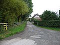
 Byford Common Lane - geograph.org.uk - 2786965.jpg 1 024 × 577 ; 329 kio
-
 Byford Court - geograph.org.uk - 6381729.jpg 3 648 × 2 736 ; 4,2 Mio
-
 Byford Court - geograph.org.uk - 6381799.jpg 3 648 × 2 736 ; 4,64 Mio
-
 Byford House - geograph.org.uk - 6382905.jpg 1 994 × 1 496 ; 674 kio
-
 Byford village - geograph.org.uk - 3723230.jpg 2 592 × 1 944 ; 1,44 Mio
-
 Canoes on the Wye, at The Weir - geograph.org.uk - 735467.jpg 640 × 480 ; 113 kio
-
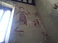
 Ceiling inside St. John the Baptist Church (Chancel ^ Byford) - geograph.org.uk - 6382829.jpg 3 648 × 2 056 ; 1,98 Mio
-
 Ceiling inside St. John the Baptist Church (Chancel ^ Byford) - geograph.org.uk - 6382860.jpg 3 648 × 2 736 ; 2,96 Mio
-
 Ceiling inside St. John the Baptist Church (Nave ^ Byford) - geograph.org.uk - 6382852.jpg 3 648 × 2 056 ; 1,95 Mio
-
 Church Lane (Byford) - geograph.org.uk - 6381727.jpg 3 648 × 2 736 ; 4,79 Mio
-
 Churchyard at St. John the Baptist Church (Byford) - geograph.org.uk - 6381734.jpg 3 648 × 2 736 ; 4,88 Mio
-
 Churchyard at St. John the Baptist Church (Byford) - geograph.org.uk - 6382868.jpg 3 648 × 2 736 ; 4,78 Mio
-
 Churchyard at St. John the Baptist Church (Byford) - geograph.org.uk - 6382881.jpg 3 648 × 2 736 ; 4,64 Mio
-
 Churchyard at St. John the Baptist Church (Byford) - geograph.org.uk - 6382888.jpg 3 648 × 2 736 ; 5,06 Mio
-
 Country north of Byford - geograph.org.uk - 3723235.jpg 2 592 × 1 944 ; 1,25 Mio
-
 Cricket ground, Garnons - geograph.org.uk - 2584452.jpg 3 201 × 1 634 ; 5,04 Mio
-
 Entrance Gates to St. John the Baptist Church (Byford) - geograph.org.uk - 6381732.jpg 3 648 × 2 736 ; 4,69 Mio
-
 Fallsbrook Farm, Byford - geograph.org.uk - 3918584.jpg 3 852 × 2 415 ; 2,17 Mio
-
 Fallsbrook Farm, Byford - geograph.org.uk - 3918612.jpg 4 512 × 3 000 ; 4,54 Mio
-

-
 Ford at Byford - geograph.org.uk - 4293889.jpg 3 872 × 2 592 ; 4,65 Mio
-
 Former Barn, Lower Farm, Byford - geograph.org.uk - 6318317.jpg 3 323 × 2 209 ; 2,61 Mio
-
 Former Barn, Lower Farm, Byford - geograph.org.uk - 6318326.jpg 3 323 × 2 209 ; 2,35 Mio
-
 Gardener's Cottage, Garnons - geograph.org.uk - 2586368.jpg 3 301 × 2 142 ; 6,83 Mio
-
 Gardener's Cottage, Garnons - geograph.org.uk - 2586371.jpg 3 178 × 2 089 ; 5,65 Mio
-
 Home Farm Cottages - geograph.org.uk - 4274042.jpg 640 × 480 ; 60 kio
-
 House and pond at Byford - geograph.org.uk - 2788211.jpg 1 024 × 768 ; 534 kio
-
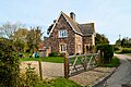 House in Byford, Herefordshire (geograph 6318376 by Philip Pankhurst).jpg 3 323 × 2 209 ; 2,52 Mio
-
 Lintel inside St. John the Baptist Church (South Aisle ^ Byford) - geograph.org.uk - 6382737.jpg 3 648 × 2 056 ; 2,37 Mio
-
 Lodge - geograph.org.uk - 4274047.jpg 640 × 480 ; 139 kio
-
 Lodge, Garnons - geograph.org.uk - 2584420.jpg 3 424 × 2 164 ; 7,39 Mio
-
 Lower Farmhouse, Byford - geograph.org.uk - 6318250.jpg 3 498 × 2 098 ; 1,87 Mio
-
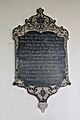
 Memorial of John Geers Cotterell (Byford) - geograph.org.uk - 6382724.jpg 3 648 × 2 736 ; 2,75 Mio
-
 Memorial of John Henry Cotterell (Byford) - geograph.org.uk - 6382784.jpg 1 821 × 1 536 ; 504 kio
-
 Memorial of Uvedale and Margery King (Byford) - geograph.org.uk - 6382700.jpg 3 648 × 2 736 ; 2,56 Mio
-
 Memorial of William Wootton (Byford) - geograph.org.uk - 6382862.jpg 3 648 × 2 736 ; 3,39 Mio
-
 Milestone Cottage - geograph.org.uk - 4274039.jpg 640 × 480 ; 70 kio
-
 Ordnance Survey Cut Mark - geograph.org.uk - 4757826.jpg 480 × 640 ; 123 kio
-
 Parkland at Garnons - geograph.org.uk - 2788216.jpg 1 024 × 577 ; 318 kio
-
 Parkland at the Garnons - geograph.org.uk - 729274.jpg 640 × 426 ; 101 kio
-
 Path to St. John the Baptist Church (Byford) - geograph.org.uk - 6381775.jpg 3 648 × 2 736 ; 4,82 Mio
-
 Porch of house in Byford, Herefordshire (geograph 6318389 by Philip Pankhurst).jpg 1 900 × 3 863 ; 3 Mio
-
 Rainbow at Byford - geograph.org.uk - 6382903.jpg 3 648 × 2 736 ; 4,68 Mio
-
 Sign at St. John the Baptist Church (Byford) - geograph.org.uk - 6381726.jpg 3 648 × 2 736 ; 4,25 Mio
-
 Snowdrops at St. John the Baptist Church (Byford) - geograph.org.uk - 6381742.jpg 1 703 × 1 385 ; 792 kio
-
 Snowdrops at St. John the Baptist Church (Byford) - geograph.org.uk - 6381804.jpg 3 648 × 2 736 ; 4,96 Mio
-
 Snowdrops at St. John the Baptist Church (Byford) - geograph.org.uk - 6381806.jpg 3 648 × 2 736 ; 4,87 Mio
-
 St John the Baptist, Byford - Chancel - geograph.org.uk - 3885582.jpg 369 × 528 ; 289 kio
-
 St John the Baptist, Byford - East end - geograph.org.uk - 3885581.jpg 520 × 376 ; 293 kio
-
 St John the Baptist, Byford - Font - geograph.org.uk - 3885592.jpg 326 × 454 ; 221 kio
-
 St John the Baptist, Byford - geograph.org.uk - 3885580.jpg 507 × 376 ; 266 kio
-
 St John the Baptist, Byford - geograph.org.uk - 3918495.jpg 2 712 × 1 901 ; 1,25 Mio
-
 St John the Baptist, Byford - geograph.org.uk - 3918507.jpg 4 512 × 3 000 ; 3,28 Mio
-
 St John the Baptist, Byford - geograph.org.uk - 3918517.jpg 2 829 × 4 100 ; 2,51 Mio
-
 St John the Baptist, Byford - geograph.org.uk - 3918522.jpg 4 125 × 2 742 ; 1,88 Mio
-
 St John the Baptist, Byford - geograph.org.uk - 3918540.jpg 1 761 × 2 582 ; 911 kio
-
 St John the Baptist, Byford - geograph.org.uk - 3918553.jpg 4 001 × 2 384 ; 1,05 Mio
-
 St John the Baptist, Byford - geograph.org.uk - 3918597.jpg 3 973 × 2 244 ; 1,81 Mio
-
 St John the Baptist, Byford - geograph.org.uk - 4502722.jpg 4 512 × 3 000 ; 4,16 Mio
-
 St John the Baptist, Byford - geograph.org.uk - 6318352.jpg 3 498 × 2 098 ; 2,44 Mio
-
 St John the Baptist, Byford - geograph.org.uk - 6319333.jpg 3 302 × 2 223 ; 2,34 Mio
-
 St John the Baptist, Byford - geograph.org.uk - 6319550.jpg 3 563 × 2 060 ; 2,61 Mio
-
 St John the Baptist, Byford - geograph.org.uk - 6321390.jpg 2 239 × 3 278 ; 1,82 Mio
-
 St John the Baptist, Byford - geograph.org.uk - 6321404.jpg 3 323 × 2 209 ; 2,41 Mio
-
 St John the Baptist, Byford - geograph.org.uk - 6321436.jpg 2 299 × 3 192 ; 1,83 Mio
-
 St John the Baptist, Byford - geograph.org.uk - 6321450.jpg 2 209 × 3 322 ; 1,84 Mio
-
 St John the Baptist, Byford - geograph.org.uk - 6321459.jpg 2 209 × 3 323 ; 1,43 Mio
-
 St John the Baptist, Byford - geograph.org.uk - 6321462.jpg 2 209 × 3 323 ; 1,32 Mio
-
 St John the Baptist, Byford - geograph.org.uk - 6321470.jpg 3 097 × 2 370 ; 2,19 Mio
-
 St John the Baptist, Byford - geograph.org.uk - 6323111.jpg 3 323 × 2 209 ; 1,58 Mio
-
 St John the Baptist, Byford - geograph.org.uk - 6323132.jpg 3 015 × 2 435 ; 1,46 Mio
-
 St John the Baptist, Byford - geograph.org.uk - 6323140.jpg 3 323 × 2 209 ; 2,22 Mio
-
 St John the Baptist, Byford - geograph.org.uk - 6325421.jpg 2 209 × 3 323 ; 1,91 Mio
-
 St John the Baptist, Byford - geograph.org.uk - 6325426.jpg 3 322 × 2 209 ; 2,36 Mio
-
 St John the Baptist, Byford - geograph.org.uk - 6325437.jpg 3 323 × 2 209 ; 1,85 Mio
-
 St John the Baptist, Byford - geograph.org.uk - 6325443.jpg 2 726 × 2 692 ; 2,1 Mio
-
 St John the Baptist, Byford - geograph.org.uk - 6325457.jpg 2 336 × 3 142 ; 2,24 Mio
-
 St John the Baptist, Byford - geograph.org.uk - 6326202.jpg 2 167 × 3 388 ; 2,3 Mio
-
 St John the Baptist, Byford - geograph.org.uk - 6326211.jpg 2 473 × 2 968 ; 1,86 Mio
-
 St John the Baptist, Byford - geograph.org.uk - 6326223.jpg 2 357 × 3 114 ; 2,93 Mio
-
 St John the Baptist, Byford - geograph.org.uk - 6326234.jpg 2 324 × 3 159 ; 1,65 Mio
-
 St John the Baptist, Byford - geograph.org.uk - 6326238.jpg 2 320 × 3 164 ; 2,61 Mio
-
 St John the Baptist, Byford - geograph.org.uk - 6326246.jpg 3 322 × 2 209 ; 2,02 Mio
-
 St John the Baptist, Byford - geograph.org.uk - 6326751.jpg 2 654 × 2 592 ; 3,13 Mio
-
 St John the Baptist, Byford - geograph.org.uk - 6326818.jpg 2 209 × 3 323 ; 1,93 Mio
-
 St John the Baptist, Byford - geograph.org.uk - 6326831.jpg 2 447 × 3 000 ; 2,07 Mio
-
 St John the Baptist, Byford - geograph.org.uk - 6326842.jpg 2 128 × 3 449 ; 2,16 Mio
-
 St John the Baptist, Byford - Interior - geograph.org.uk - 3885586.jpg 349 × 528 ; 247 kio
-
 St John the Baptist, Byford - Interior - geograph.org.uk - 3885589.jpg 510 × 375 ; 259 kio
-
 St. John the Baptist Church (Bell Tower ^ Byford) - geograph.org.uk - 6381738.jpg 3 648 × 2 736 ; 4,23 Mio
-
 St. John the Baptist Church (Bell Tower ^ Byford) - geograph.org.uk - 6381744.jpg 1 987 × 1 490 ; 781 kio
-
 St. John the Baptist Church (Bell Tower ^ Byford) - geograph.org.uk - 6381748.jpg 3 648 × 2 736 ; 4,72 Mio
-
 St. John the Baptist Church (Bell Tower ^ Byford) - geograph.org.uk - 6381749.jpg 3 648 × 2 736 ; 4,63 Mio
-
 St. John the Baptist Church (Bell Tower ^ Porch ^ Byford) - geograph.org.uk - 6382894.jpg 3 648 × 2 736 ; 4,63 Mio
-
 St. John the Baptist Church (Byford) - geograph.org.uk - 6381722.jpg 3 648 × 2 736 ; 4,17 Mio
-
 St. John the Baptist Church (Byford) - geograph.org.uk - 6381811.jpg 3 648 × 2 736 ; 4,65 Mio
-
 St. John the Baptist Church (Byford) - geograph.org.uk - 6382691.jpg 3 648 × 2 056 ; 2,42 Mio
-
 St. John the Baptist Church (Byford) - geograph.org.uk - 6382884.jpg 1 966 × 1 496 ; 762 kio
-
 St. John the Baptist Church (Byford) - geograph.org.uk - 6382904.jpg 3 648 × 2 736 ; 3,71 Mio
-
 St. John the Baptist Church (Chancel ^ Byford) - geograph.org.uk - 6382856.jpg 3 648 × 2 736 ; 2,94 Mio
-
 St. John the Baptist Church (Close-Up of the Bell Tower ^ Byford) - geograph.org.uk - 6382887.jpg 3 648 × 2 736 ; 4,69 Mio
-
 St. John the Baptist Church (Font ^ Byford) - geograph.org.uk - 6382679.jpg 3 648 × 2 736 ; 2,62 Mio
-
 St. John the Baptist Church (Lectern ^ Byford) - geograph.org.uk - 6382824.jpg 3 648 × 2 736 ; 2,56 Mio
-
 St. John the Baptist Church (Nave ^ Byford) - geograph.org.uk - 6382848.jpg 3 648 × 2 736 ; 2,63 Mio
-
 St. John the Baptist Church (Organ ^ Byford) - geograph.org.uk - 6382689.jpg 3 648 × 2 736 ; 2,66 Mio
-
 St. John the Baptist Church (Porch ^ Byford) - geograph.org.uk - 6381752.jpg 3 648 × 2 736 ; 4,75 Mio
-
 St. John the Baptist Church (Pulpit ^ Byford) - geograph.org.uk - 6382854.jpg 3 648 × 2 736 ; 2,57 Mio
-
 St. John the Baptist Church (South Aisle ^ Byford) - geograph.org.uk - 6382817.jpg 3 648 × 2 736 ; 3,12 Mio
-
 St. John the Baptist Church (South Aisle ^ Byford) - geograph.org.uk - 6382864.jpg 3 648 × 2 736 ; 3,52 Mio
-
 St. John the Baptist Church (South Transept ^ Byford) - geograph.org.uk - 6382812.jpg 2 048 × 1 536 ; 631 kio
-
 St. John the Baptist Church (War Memorial ^ Byford) - geograph.org.uk - 6382742.jpg 3 648 × 2 736 ; 2,73 Mio
-
 The Steps, Garnons - geograph.org.uk - 2586363.jpg 3 456 × 2 592 ; 6,27 Mio
-
 Tractor muddied parkland - geograph.org.uk - 4274045.jpg 640 × 480 ; 120 kio
-

-
-
 Window inside St. John the Baptist Church (Chancel ^ Byford) - geograph.org.uk - 6382835.jpg 2 736 × 3 648 ; 4,08 Mio
-
 Window inside St. John the Baptist Church (Chancel ^ Byford) - geograph.org.uk - 6382839.jpg 2 736 × 3 648 ; 4,83 Mio
-
 Window inside St. John the Baptist Church (Chancel ^ Byford) - geograph.org.uk - 6382843.jpg 2 736 × 3 648 ; 4,24 Mio
-
 Window inside St. John the Baptist Church (South Aisle ^ Byford) - geograph.org.uk - 6382731.jpg 3 648 × 2 736 ; 3,62 Mio
-
 Window inside St. John the Baptist Church (South Transept ^ Byford) - geograph.org.uk - 6382808.jpg 2 736 × 3 648 ; 4,43 Mio
-
 Yew Tree at St. John the Baptist Church (Byford) - geograph.org.uk - 6382890.jpg 3 648 × 2 736 ; 4,95 Mio
-
 Apple orchard near Byford - geograph.org.uk - 317658.jpg 640 × 426 ; 141 kio
-
 Bridleway to Preston-on-Wye - geograph.org.uk - 349075.jpg 640 × 480 ; 126 kio
-
 Cider Press, Lulham Court - geograph.org.uk - 359054.jpg 640 × 480 ; 136 kio
-
 Early rape - geograph.org.uk - 373561.jpg 640 × 480 ; 97 kio
-
 Farm at Byford - geograph.org.uk - 318207.jpg 640 × 426 ; 106 kio
-
 Farmland by Chestnut Coppice, Byford - geograph.org.uk - 316236.jpg 640 × 426 ; 104 kio
-
 Fields near Mancel Lacy - geograph.org.uk - 167937.jpg 640 × 480 ; 46 kio
-
 Forest of polytunnel frames - geograph.org.uk - 373563.jpg 640 × 480 ; 82 kio
-
 Garnons, Mansell Gamage - geograph.org.uk - 316220.jpg 640 × 426 ; 116 kio
-
 Hereford to Brecon Line 1 - geograph.org.uk - 373571.jpg 640 × 480 ; 114 kio
-
 Hereford to Brecon Line 2 - geograph.org.uk - 373577.jpg 640 × 480 ; 122 kio
-
 Hop Fields - geograph.org.uk - 359061.jpg 640 × 480 ; 131 kio
-
 Houses by the Roman Road - geograph.org.uk - 373534.jpg 640 × 480 ; 86 kio
-
 Marsh Court - geograph.org.uk - 362882.jpg 640 × 480 ; 110 kio
-
 Old farm buildings at Lulham - geograph.org.uk - 349070.jpg 640 × 480 ; 102 kio
-
 Over the Wye - geograph.org.uk - 349076.jpg 640 × 480 ; 87 kio
-
 Rape field - geograph.org.uk - 167926.jpg 640 × 480 ; 32 kio
-
 Roman Road - Offa's Dyke intersection - geograph.org.uk - 362905.jpg 640 × 480 ; 108 kio
-
 The A438 at Byford - geograph.org.uk - 318210.jpg 640 × 426 ; 122 kio
-
 Verdant glade at "The Weir" - geograph.org.uk - 82276.jpg 480 × 640 ; 147 kio


_-_geograph.org.uk_-_6382829.jpg)
_-_geograph.org.uk_-_6382860.jpg)
_-_geograph.org.uk_-_6382852.jpg)
_-_geograph.org.uk_-_6381727.jpg)
_-_geograph.org.uk_-_6381734.jpg)
_-_geograph.org.uk_-_6382868.jpg)
_-_geograph.org.uk_-_6382881.jpg)
_-_geograph.org.uk_-_6382888.jpg)


_-_geograph.org.uk_-_6381732.jpg)


_-_geograph.org.uk_-_6382706.jpg)


.jpg)
_-_geograph.org.uk_-_6382737.jpg)


_-_geograph.org.uk_-_6382724.jpg)
_-_geograph.org.uk_-_6382784.jpg)
_-_geograph.org.uk_-_6382700.jpg)
_-_geograph.org.uk_-_6382862.jpg)


_-_geograph.org.uk_-_6381775.jpg)
.jpg)

_-_geograph.org.uk_-_6381726.jpg)
_-_geograph.org.uk_-_6381742.jpg)
_-_geograph.org.uk_-_6381804.jpg)
_-_geograph.org.uk_-_6381806.jpg)


_-_geograph.org.uk_-_6381738.jpg)
_-_geograph.org.uk_-_6381744.jpg)
_-_geograph.org.uk_-_6381748.jpg)
_-_geograph.org.uk_-_6381749.jpg)
_-_geograph.org.uk_-_6382894.jpg)
_-_geograph.org.uk_-_6381722.jpg)
_-_geograph.org.uk_-_6381811.jpg)
_-_geograph.org.uk_-_6382691.jpg)
_-_geograph.org.uk_-_6382884.jpg)
_-_geograph.org.uk_-_6382904.jpg)
_-_geograph.org.uk_-_6382856.jpg)
_-_geograph.org.uk_-_6382887.jpg)
_-_geograph.org.uk_-_6382679.jpg)
_-_geograph.org.uk_-_6382824.jpg)
_-_geograph.org.uk_-_6382848.jpg)
_-_geograph.org.uk_-_6382689.jpg)
_-_geograph.org.uk_-_6381752.jpg)
_-_geograph.org.uk_-_6382854.jpg)
_-_geograph.org.uk_-_6382817.jpg)
_-_geograph.org.uk_-_6382864.jpg)
_-_geograph.org.uk_-_6382742.jpg)


_-_geograph.org.uk_-_6382835.jpg)
_-_geograph.org.uk_-_6382839.jpg)
_-_geograph.org.uk_-_6382843.jpg)
_-_geograph.org.uk_-_6382731.jpg)
_-_geograph.org.uk_-_6382890.jpg)


_-_geograph.org.uk_-_6382812.jpg)
_-_geograph.org.uk_-_6382803.jpg)
_-_geograph.org.uk_-_6382805.jpg)
_-_geograph.org.uk_-_6382808.jpg)