Category:Caherdaniel
Перейти к навигации
Перейти к поиску
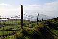
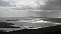
English: Caherdaniel is a village in County Kerry, Ireland, located on the Iveragh peninsula on the Ring of Kerry. It is situated on the southwestern side of the peninsula, facing onto Derrynane Bay, at a T-junction on the N70 road.
Gaeilge: Sráidbhaile in Éirinn is ea Cathair Dhónaill. Tá an sráidbhaile suite in iardheisceart na tíre i gContae Chiarraí.
town in Munster, Ireland _Ring_Fort_-_geograph.org.uk_-_1432501.jpg) | |||||
| Медиафайл | |||||
| Это частный случай понятия | |||||
|---|---|---|---|---|---|
| Местонахождение | Керри, Манстер, Ирландия | ||||
| Высота над уровнем моря |
| ||||
 | |||||
Файлы в категории «Caherdaniel»
Показано 54 файла из 54, находящихся в данной категории.
-
 909 Caherdaniel, County Galway.jpg 3264 × 2448; 1,79 МБ
-
 A fire tongued score on the mountain outside Caherdaniel.jpg 240 × 180; 9 КБ
-
 Balla Íseal (12282955704).jpg 5652 × 3768; 12,56 МБ
-
 Beach on Cove Harbour, near Caherdaniel - geograph.org.uk - 449342.jpg 640 × 413; 119 КБ
-

-

-
 Butter Road, above Caherdaniel - geograph.org.uk - 248833.jpg 439 × 640; 94 КБ
-
 Caherdaniel - geograph.org.uk - 1361343.jpg 640 × 457; 334 КБ
-
 Caherdaniel - geograph.org.uk - 1361346.jpg 640 × 457; 277 КБ
-
 Caherdaniel Primary School - geograph.org.uk - 575455.jpg 640 × 480; 92 КБ
-
 Caherdaniel Viewpoint - Ring of Kerry (12282681623).jpg 5759 × 2685; 10,71 МБ
-
 Caherdaniel, County Kerry (5263124213).jpg 2000 × 1321; 1,24 МБ
-
 Carroll's Cove, Co. Kerry - geograph.org.uk - 250383.jpg 640 × 480; 79 КБ
-
 Cottage by N70 - geograph.org.uk - 6002735.jpg 1024 × 588; 150 КБ
-
 Darrynane Beg, Co. Kerry, Ireland - panoramio (1).jpg 4320 × 3240; 3,32 МБ
-

-
 House at Darrynane Beach - geograph.org.uk - 247223.jpg 640 × 425; 120 КБ
-
 House beneath Knocknasullig - geograph.org.uk - 457552.jpg 640 × 401; 103 КБ
-
 House by Cove Harbour - geograph.org.uk - 457603.jpg 640 × 426; 128 КБ
-
-
 Knocknasullig, near Cove Harbour - geograph.org.uk - 449114.jpg 640 × 427; 126 КБ
-
 L7541 off Ring of Kerry - geograph.org.uk - 6002752.jpg 1024 × 537; 128 КБ
-
-
 Low tide at Abbey Island. - geograph.org.uk - 539188.jpg 640 × 480; 76 КБ
-

-

-
 N70 at Caherdaniel - geograph.org.uk - 6002744.jpg 1024 × 577; 136 КБ
-
 Ring of Kerry - geograph.org.uk - 6002774.jpg 1024 × 856; 193 КБ
-
 Ring of Kerry-Caherdaniel-02-bei Scarriff Inn-2017-gje.jpg 5184 × 2841; 2,73 МБ
-
 Ring of Kerry-Caherdaniel-04-bei Scarriff Inn-2017-gje.jpg 5184 × 3456; 3,21 МБ
-
 Ring of Kerry-Caherdaniel-06-bei Scarriff Inn-2017-gje.jpg 4993 × 3206; 2,57 МБ
-
 Ring of Kerry-Caherdaniel-08-bei Scarriff Inn-Zaun-2017-gje.jpg 5184 × 2939; 2,6 МБ
-
-
 Ring of Kerry-Caherdaniel-12-bei Scarriff Inn-Zaun-Leiter-2017-gje.jpg 3456 × 4350; 2,62 МБ
-

-
 Ring of Kerry-Caherdaniel-16-bei Scarriff Inn-Weiden-2017-gje.jpg 5184 × 3456; 5,37 МБ
-
 Ring of Kerry-Caherdaniel-18-bei Scarriff Inn-Weiden-2017-gje.jpg 5184 × 3456; 4,64 МБ
-
 Ring of Kerry-Caherdaniel-20-bei Scarriff Inn-Weiden-2017-gje.jpg 5036 × 3163; 3,27 МБ
-
 Ring of Kerry-Caherdaniel-22-bei Scarriff Inn-2017-gje.jpg 5184 × 3456; 4,95 МБ
-
 Ring of Kerry-Caherdaniel-24-bei Scarriff Inn-Wolken und Meer-2017-gje.jpg 5063 × 2880; 1,71 МБ
-
 Ring of Kerry-Caherdaniel-26-bei Scarriff Inn-Wolken und Meer-2017-gje.jpg 5184 × 2899; 1,88 МБ
-
 Ring of Kerry-Caherdaniel-30-Schafe auf der Weide-1989-gje.jpg 2717 × 1803; 2,38 МБ
-
 Ring of Kerry-Caherdaniel-32-Inseln Deenish und Scariff-1989-gje.jpg 2595 × 1670; 2,02 МБ
-
 Ring of Kerry-Caherdaniel-34-Inseln Deenish und Scariff-1989-gje.jpg 2717 × 1685; 2,06 МБ
-
 Ring of Kerry-Caherdaniel-36-Kueste-Inseln-Strand-1989-gje.jpg 2679 × 1634; 1,89 МБ
-
 Road Sign at Junction of Rath Road - geograph.org.uk - 248805.jpg 427 × 640; 94 КБ
-
 Rocky inlet on Cove Harbour - geograph.org.uk - 449197.jpg 640 × 427; 130 КБ
-
 Rocky inlet on Cove Harbour, view NNE - geograph.org.uk - 457584.jpg 640 × 411; 133 КБ
-
 Senator Mark Daly.JPG 3072 × 2304; 2,86 МБ
-
 The school looks safe and there will be school tomorrow.jpg 240 × 180; 9 КБ
-
 Tildes of mountain fire outside Caherdaniel.jpg 240 × 180; 8 КБ
-
 Trig Pillar - geograph.org.uk - 1932299.jpg 600 × 400; 248 КБ
-
 View of the Strand from Abbey Island - geograph.org.uk - 1391923.jpg 640 × 427; 284 КБ
-


.jpg)


.jpg)
.jpg)


.jpg)


