Category:Caserne du Bon Pasteur (Rennes)
Jump to navigation
Jump to search
| Object location | | View all coordinates using: OpenStreetMap |
|---|
|
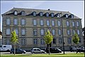
This building is inscrit au titre des monuments historiques de la France. It is indexed in the base Mérimée, a database of architectural heritage maintained by the French Ministry of Culture, under the reference PA00090674
|
| Geocoded outline |
OpenStreetMap Caserne du Bon Pasteur (Rennes) |
|---|
 | |||||
| Upload media | |||||
| Instance of | |||||
|---|---|---|---|---|---|
| Location | Rennes, arrondissement of Rennes, Ille-et-Vilaine, Brittany, Q88521114, Metropolitan France, France | ||||
| Located on street |
| ||||
| Architect |
| ||||
| Heritage designation |
| ||||
| Inception |
| ||||
 | |||||
Media in category "Caserne du Bon Pasteur (Rennes)"
The following 6 files are in this category, out of 6 total.
-
 100Fi563 Caserne du Bon Pasteur de Rennes.jpg 1,635 × 1,038; 399 KB
-
 Caserne du bon pasteur.jpg 1,417 × 947; 1.06 MB
-
 Façade de l'hôtel Bon Pasteur - 1966.jpg 904 × 617; 457 KB
-
 Façade de l'hôtel Bon Pasteur - 1986.jpg 1,003 × 667; 687 KB
-
 Rennes - CaserneduBonPasteur.jpg 3,008 × 2,000; 4.74 MB
-
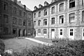 Vue arrière Hôtel Bon Pasteur - 1966.jpg 1,003 × 667; 505 KB


