Category:Census of India, 2011
नेविगेशन पर जाएँ
खोज पर जाएँ
15th Indian census  | |||||
| मीडिया अपलोड करें | |||||
| जिसका उदाहरण है | |||||
|---|---|---|---|---|---|
| स्थान | हिंद | ||||
| समय |
| ||||
| आधिकारिक वेबसाइट | |||||
| |||||
"Census of India, 2011" श्रेणी में मीडिया
इस श्रेणी की कुल २६ में से २६ चित्र निम्नलिखित हैं।
-
 2011 Census India literacy distribution map by states and union territories.svg १,५०० × १,६१५; १.८९ MB
-
 2011 Census India population density map, states and union territories.svg १,५७८ × १,७३८; ८६३ KB
-

-
 2011 Census Scheduled Caste caste distribution map India by state and union territory.svg १,६५० × १,८६२; १.४४ MB
-

-
 2011 Census Scheduled Tribes distribution map India by state and union territory.svg १,५०० × १,६१५; १.४ MB
-

-

-
 Alphabetisierungsrate Indien 2011.svg ८२८ × ९२९; ८८६ KB
-
 Alphabetisierungsraten Indien 2011.svg ९६७ × १,१३४; ५३८ KB
-
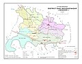
 Aurai Block Map (2011 census).jpg ३,५०७ × २,४८२; २.०१ MB
-
 Babul roy.JPG ३,२१६ × २,१३६; १.७२ MB
-
 Bhadohi 3 page-0001.jpg १,६५० × १,२७५; ८७५ KB
-
 Census, TamilNadu-219 (year-2011).jpg २,५५० × ३,३१०; २.२८ MB
-
 Census-2011 work in progress at Parengaon, Near Rinchengpong, West Sikkim.jpg २,१०० × १,५०१; ५७९ KB
-
 Data from census2011, Govt of India.jpg ७६९ × ३९७; ४८ KB
-
 District wise Buddhist population percentage, India census 2011.png २,००० × २,२०८; २.६७ MB
-
-
 Gogunda Tehsil Map from District Census Handbook 2011.jpg १,१०८ × १,५७१; ४४० KB
-
 Islam in India (2011).svg १,६४३ × १,८५६; २५७ KB
-
 Kotra tehsil map Census 2011.jpg १,०३५ × १,४९७; ३७६ KB
-
 Language Families of Odisha.svg ५१२ × ३६२; ८९९ KB
-
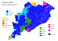 Languages of Odisha.svg ५१२ × ३६२; २.५२ MB
-
 Map of Kherwara tehsil from Census of India 2011.jpg ४,५३४ × ६,५५३; ११.६७ MB
-
 Map of Udaipur District, Rajasthan, India.jpg ५४४ × ५६८; ५३ KB
-
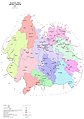 Udaipur district map.jpg २,१२९ × ३,०२५; १.०४ MB


.jpg)


.jpg)


,_Kashmiri_(second),_Gujarati_%26_Meitei_alias_Manipuri_(third),_Bengali_(fourth)_%E2%80%94_based_on_2011_census_of_India.jpg)

.svg)


