Category:Cham Marktplatz 6
Jump to navigation
Jump to search
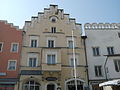
This is the category of the Bavarian Baudenkmal (cultural heritage monument) with the ID D-3-72-116-35 (Wikidata)
|
| Object location | | View all coordinates using: OpenStreetMap |
|---|
building in Cham, Upper Palatinate, Germany  | |||||
| Upload media | |||||
| Instance of | |||||
|---|---|---|---|---|---|
| Location | Cham, Upper Palatinate, Bavaria, Germany | ||||
| Street address |
| ||||
| Heritage designation | |||||
 | |||||
Media in category "Cham Marktplatz 6"
The following 10 files are in this category, out of 10 total.
-
 ChamMarktPlatz6.JPG 3,968 × 2,976; 2.77 MB
-
 ChamMarktplatz6Innen 01.jpg 2,304 × 1,704; 682 KB
-
 ChamMarktplatz6Innen 02.jpg 2,304 × 1,704; 771 KB
-
 ChamMarktplatz6Innen 03.jpg 2,304 × 1,704; 530 KB
-
 ChamMarktplatz6Innen 04.jpg 2,304 × 1,704; 611 KB
-
 ChamMarktplatz6Innen 05.jpg 2,304 × 1,704; 449 KB
-
 ChamMarktplatz6Innen 06.jpg 2,304 × 1,704; 555 KB
-
 ChamMarktplatz6Innen 07.jpg 2,304 × 1,704; 800 KB
-
 ChamMarktplatz6Innen 08.jpg 2,304 × 1,704; 690 KB
-
 ChamMarktplatz6Innen 09.jpg 2,304 × 1,704; 767 KB


