Category:Chapelle Saint-Clair de Verdun
Jump to navigation
Jump to search
| Object location | | View all coordinates using: OpenStreetMap |
|---|
|
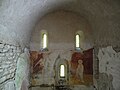
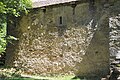
This building is inscrit au titre des monuments historiques de la France. It is indexed in the base Mérimée, a database of architectural heritage maintained by the French Ministry of Culture, under the reference PA12000018
|
chapel located in Aveyron, in France  | |||||
| Upload media | |||||
| Instance of | |||||
|---|---|---|---|---|---|
| Location | Quins, canton of Naucelle | ||||
| Street address |
| ||||
| Heritage designation |
| ||||
 | |||||
Media in category "Chapelle Saint-Clair de Verdun"
The following 15 files are in this category, out of 15 total.
-
 Accès à la chapelle Saint-Clair.JPG 3,000 × 4,000; 4.28 MB
-
 Chapelle Saint-Clair de Verdun 01.JPG 3,000 × 4,000; 5.96 MB
-
 Chapelle Saint-Clair de Verdun 02.JPG 4,000 × 3,000; 5.95 MB
-
 Choeur de la chapelle saint Clair de Verdun.JPG 4,000 × 3,000; 6.25 MB
-
 Façade de la chapelle Saint-Clair.JPG 3,000 × 4,000; 4.08 MB
-
 L'une des des façades de la chapelle Saint-Clair.JPG 3,000 × 4,000; 4.03 MB
-
 Verdun - Chapelle Saint-Clair - 01.jpg 4,000 × 6,000; 3.65 MB
-
 Verdun - Chapelle Saint-Clair - 02.jpg 6,000 × 4,000; 4.77 MB
-
 Verdun - Chapelle Saint-Clair - 03.jpg 6,000 × 4,000; 4.11 MB
-
 Verdun - Chapelle Saint-Clair - 04.jpg 6,000 × 4,000; 5.63 MB
-
 Verdun - Chapelle Saint-Clair - 05.jpg 5,463 × 3,642; 3.13 MB
-
 Verdun - Chapelle Saint-Clair - 06.jpg 3,756 × 5,634; 2.95 MB
-
 Verdun - Chapelle Saint-Clair - 07.jpg 6,000 × 4,000; 12.49 MB
-
 Verdun - Chapelle Saint-Clair - 08.jpg 6,000 × 4,000; 13.49 MB
-
 Vierge à l'enfant de saint Clair de Verdun.JPG 3,000 × 4,000; 5.04 MB


