Category:Chapelle Saint-Erard (Riquewihr)
Jump to navigation
Jump to search
| Object location | | View all coordinates using: OpenStreetMap |
|---|
|
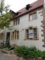
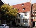
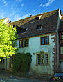
This building is inscrit au titre des monuments historiques de la France. It is indexed in the base Mérimée, a database of architectural heritage maintained by the French Ministry of Culture, under the references PA00085604
|
chapel located in Haut-Rhin, in France  | |||||
| Upload media | |||||
| Instance of | |||||
|---|---|---|---|---|---|
| Part of | |||||
| Location | Riquewihr, canton of Kaysersberg | ||||
| Heritage designation | |||||
 | |||||
Media in category "Chapelle Saint-Erard (Riquewihr)"
The following 6 files are in this category, out of 6 total.
-
 20191207 Chapelle Saint-Erard Riquewihr.jpg 6,032 × 4,032; 1.76 MB
-
 Riquewihr rTroisEglises 14-15.JPG 3,648 × 2,736; 2.82 MB
-
 Riquewihr rTroisEglises 14.JPG 2,736 × 3,648; 2.77 MB
-
 Riquewihr rTroisEglises Puits.JPG 2,736 × 3,648; 3.15 MB
-
 Riquewihr, Ancienne chapelle Saint-Erard.jpg 2,741 × 2,141; 5.49 MB
-
 Riquewihr-0082.jpg 2,632 × 3,454; 2.78 MB


Categories:
- Rue des Trois-Églises (Riquewihr)
- Churches in Riquewihr
- Monuments historiques in Riquewihr
- Monuments historiques in Haut-Rhin (chapels)
- Saint Erhard chapels in Haut-Rhin
- Chapels in Arrondissement Colmar-Ribeauvillé
- Gothic chapels in Haut-Rhin
- 14th-century architecture in Riquewihr
- 14th-century chapels in Haut-Rhin
- 16th-century architecture in Riquewihr
- 16th-century chapels in Haut-Rhin
- Built in Haut-Rhin in 1539
- Former hospitals in France
- Former schools in Arrondissement Colmar-Ribeauvillé