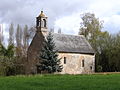
Category:Chapelle Saint-Hilaire-et-Saint-Eutrope de Verniette (Conlie)
Jump to navigation
Jump to search
| Object location | | View all coordinates using: OpenStreetMap |
|---|
|
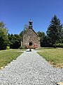
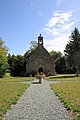
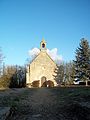
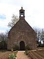
This building is classé au titre des monuments historiques de la France. It is indexed in the base Mérimée, a database of architectural heritage maintained by the French Ministry of Culture, under the reference PA00109723
|
chapel located in Sarthe, in France  | |||||
| Upload media | |||||
| Instance of | |||||
|---|---|---|---|---|---|
| Dedicated to | |||||
| Location | Conlie, canton of Conlie | ||||
| Street address |
| ||||
| Architectural style | |||||
| Heritage designation |
| ||||
 | |||||
Media in category "Chapelle Saint-Hilaire-et-Saint-Eutrope de Verniette (Conlie)"
The following 9 files are in this category, out of 9 total.
-
 Chapelle de Verniette - 2020.jpg 2,448 × 3,264; 3.58 MB
-
 Chapelle de Verniette été 2020.jpg 3,168 × 4,752; 7.35 MB
-
 Chapelle de Verniette.jpg 3,000 × 4,000; 2.27 MB
-
 Conlie - Verniette chapel - 1.jpg 1,536 × 2,048; 787 KB
-
 Conlie - Verniette chapel - 2.jpg 2,048 × 1,536; 891 KB
-
 ConlieChapelleVerniette 01.jpg 5,679 × 3,791; 10.57 MB
-
 ConlieChapelleVerniette 02.jpg 4,852 × 3,466; 9.27 MB
-
 ConlieChapelleVerniette 03.jpg 5,827 × 3,890; 10.38 MB
-
 ConlieChapelleVerniette 04.jpg 3,357 × 4,900; 8.68 MB


