Category:Chapelle Saint-Sébastien-et-Saint-Bernard (Roure)
Jump to navigation
Jump to search
| Object location | | View all coordinates using: OpenStreetMap |
|---|
|
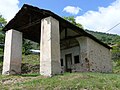
This building is classé au titre des monuments historiques de la France. It is indexed in the base Mérimée, a database of architectural heritage maintained by the French Ministry of Culture, under the reference PA00080828
|
chapel located in Alpes-Maritimes, in France   | |||||
| Upload media | |||||
| Instance of | |||||
|---|---|---|---|---|---|
| Location | Roure, canton of Saint-Sauveur-sur-Tinée | ||||
| Heritage designation |
| ||||
 | |||||
Français : Chapelle de pèlerinage sur la commune de Roure, dans les Alpes-Maritimes, France. Elle a été décorée de fresques par Andrea de Cella en 1510.
Media in category "Chapelle Saint-Sébastien-et-Saint-Bernard (Roure)"
The following 6 files are in this category, out of 6 total.
-
 Roure - Chapelle Saint-Sébastien - Saint Roch -172.jpg 2,290 × 3,570; 2.18 MB
-
 Roure - Chapelle Saint-Sébastien -175.jpg 2,736 × 3,648; 3.48 MB
-
 Roure - Chapelle Saint-Sébastien -176.jpg 3,598 × 2,736; 3.03 MB
-
 Roure - Chapelle Saint-Sébastien -178.jpg 2,373 × 3,560; 2.07 MB
-
 Roure - Chapelle Saint-Sébastien -179.jpg 2,695 × 3,280; 1.4 MB
-
 Roure - Chapelle Saint-Sébastien -180.jpg 3,648 × 2,736; 4.38 MB


Categories:
- Roure (Alpes-Maritimes)
- Primitive painters of the County of Nice
- Monuments historiques in Alpes-Maritimes (chapels)
- Frescos in Alpes-Maritimes
- 16th-century chapels in Alpes-Maritimes
- Saint Sebastian chapels in Alpes-Maritimes
- Monuments historiques in Roure (Alpes-Maritimes)
- Built in Alpes-Maritimes in 1510
- Saint Bernard chapels in Alpes-Maritimes