Category:Chapelle Saint-Théleau (Plogonnec)
Jump to navigation
Jump to search
| Object location | | View all coordinates using: OpenStreetMap |
|---|
|
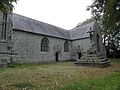
This building is classé au titre des monuments historiques de la France. It is indexed in the base Mérimée, a database of architectural heritage maintained by the French Ministry of Culture, under the reference PA00090180
|
| Object location | | View all coordinates using: OpenStreetMap |
|---|
chapel located in Finistère, Brittany  | |||||
| Upload media | |||||
| Instance of | |||||
|---|---|---|---|---|---|
| Named after | |||||
| Location | Plogonnec, Finistère, Brittany, Q88521114, Metropolitan France, France | ||||
| Architectural style | |||||
| Heritage designation |
| ||||
 | |||||
Subcategories
This category has the following 2 subcategories, out of 2 total.
Media in category "Chapelle Saint-Théleau (Plogonnec)"
The following 27 files are in this category, out of 27 total.
-
 268 Plogonnec Saint-Théleau.jpg 3,072 × 2,304; 4.24 MB
-
 269 Plogonnec Saint-Théleau.jpg 1,441 × 1,982; 1.73 MB
-
 270 Plogonnec Saint-Théleau.jpg 2,304 × 3,072; 4.09 MB
-
 271 Plogonnec Saint-Théleau.jpg 1,415 × 1,962; 1.42 MB
-
 272 Plogonnec Saint-Théleau.jpg 924 × 1,366; 829 KB
-
 274 Plogonnec Saint-Théleau.jpg 2,210 × 3,004; 3.33 MB
-
 275 Plogonnec Saint-Théleau.jpg 2,252 × 3,034; 4.75 MB
-
 276 Plogonnec Saint-Théleau.jpg 3,026 × 2,240; 3.68 MB
-
 Chapel Sant-Telo Plogonneg 01.jpg 5,184 × 3,456; 13.08 MB
-
 Chapel Sant-Telo Plogonneg 02.jpg 3,456 × 5,184; 13.05 MB
-
 Plogonnec (29) Chapelle Saint-Théleau 01.JPG 2,381 × 1,786; 1.69 MB
-
 Plogonnec (29) Chapelle Saint-Théleau 02.JPG 1,786 × 2,381; 1.59 MB
-
 Plogonnec (29) Chapelle Saint-Théleau 03.JPG 1,786 × 2,381; 2.13 MB
-
 Plogonnec (29) Chapelle Saint-Théleau 08.JPG 1,786 × 2,381; 1,013 KB
-
 Plogonnec (29) Chapelle Saint-Théleau 09.JPG 1,786 × 2,381; 1.59 MB
-
 Plogonnec (29) Chapelle Saint-Théleau 10.JPG 1,786 × 2,381; 1.85 MB
-
 Plogonnec (29) Chapelle Saint-Théleau 11.JPG 1,786 × 2,381; 1.02 MB
-
 Plogonnec (29) Chapelle Saint-Théleau 14.JPG 2,381 × 1,786; 1.02 MB
-
 Plogonnec (29) Chapelle Saint-Théleau 15.JPG 2,381 × 1,786; 868 KB
-
 Plogonnec (29) Chapelle Saint-Théleau 16.JPG 1,786 × 2,381; 1.26 MB
-
 Plogonnec (29) Chapelle Saint-Théleau 17.JPG 1,786 × 2,381; 1.1 MB
-
 Plogonnec (29) Chapelle Saint-Théleau 18.JPG 1,786 × 2,381; 1.17 MB
-
 Plogonnec (29) Chapelle Saint-Théleau 20.JPG 2,381 × 1,786; 892 KB
-
 Plogonnec (29) Chapelle Saint-Théleau 21.JPG 2,381 × 1,786; 723 KB
-
 Plogonnec (29) Chapelle Saint-Théleau 22.JPG 2,381 × 1,786; 1.71 MB
-
 Plogonnec (29) Chapelle Saint-Théleau 23.JPG 2,381 × 1,786; 1.39 MB
-
 Sant Telo Plogonneg 01.jpg 4,268 × 3,181; 9.21 MB


_Chapelle_Saint-Th%C3%A9leau_01.JPG)
_Chapelle_Saint-Th%C3%A9leau_02.JPG)
_Chapelle_Saint-Th%C3%A9leau_03.JPG)
_Chapelle_Saint-Th%C3%A9leau_08.JPG)
_Chapelle_Saint-Th%C3%A9leau_09.JPG)
_Chapelle_Saint-Th%C3%A9leau_10.JPG)
_Chapelle_Saint-Th%C3%A9leau_11.JPG)
_Chapelle_Saint-Th%C3%A9leau_14.JPG)
_Chapelle_Saint-Th%C3%A9leau_15.JPG)
_Chapelle_Saint-Th%C3%A9leau_16.JPG)
_Chapelle_Saint-Th%C3%A9leau_17.JPG)
_Chapelle_Saint-Th%C3%A9leau_18.JPG)
_Chapelle_Saint-Th%C3%A9leau_20.JPG)
_Chapelle_Saint-Th%C3%A9leau_21.JPG)
_Chapelle_Saint-Th%C3%A9leau_22.JPG)
_Chapelle_Saint-Th%C3%A9leau_23.JPG)
