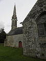
Category:Chapelle Sainte-Cécile (Briec)
Jump to navigation
Jump to search
| Object location | | View all coordinates using: OpenStreetMap |
|---|
|
This building is inscrit au titre des monuments historiques de la France. It is indexed in the base Mérimée, a database of architectural heritage maintained by the French Ministry of Culture, under the reference PA00089848
|
| Object location | | View all coordinates using: OpenStreetMap |
|---|
chapel located in Finistère, in France _Chapelle_Sainte-C%C3%A9cile_02.JPG) | |||||
| Upload media | |||||
| Instance of | |||||
|---|---|---|---|---|---|
| Location | Briec, Finistère, Brittany, Q88521114, Metropolitan France, France | ||||
| Street address |
| ||||
| Heritage designation |
| ||||
 | |||||
Subcategories
This category has the following 2 subcategories, out of 2 total.
Media in category "Chapelle Sainte-Cécile (Briec)"
The following 26 files are in this category, out of 26 total.
-
 204 Briec Chapelle Sainte-Cécile.jpg 3,888 × 5,184; 5.49 MB
-
 205 Briec Chapelle Sainte-Cécile.jpg 5,184 × 3,888; 5.66 MB
-
 208 Briec Chapelle Sainte-Cécile.jpg 3,328 × 4,401; 8.19 MB
-
 209 Briec Chapelle Sainte-Cécile.jpg 2,706 × 4,821; 6.84 MB
-
 210 Briec Chapelle Sainte-Cécile.jpg 3,724 × 5,064; 7.81 MB
-
 211 Briec Chapelle Sainte-Cécile.jpg 3,856 × 5,160; 7.67 MB
-
 212 Briec Chapelle Sainte-Cécile.jpg 5,184 × 3,888; 9.36 MB
-
 214 Briec Chapelle Sainte-Cécile.jpg 3,888 × 5,184; 11.54 MB
-
 215 Briec Chapelle Sainte-Cécile.jpg 1,517 × 3,838; 3.33 MB
-
 216 Briec Chapelle Sainte-Cécile.jpg 3,659 × 3,451; 5.51 MB
-
 217 Briec Chapelle Sainte-Cécile.jpg 3,888 × 5,184; 9.07 MB
-
 218 Briec Chapelle Sainte-Cécile.jpg 5,184 × 3,888; 10.45 MB
-
 219 Briec Chapelle Sainte-Cécile.jpg 2,590 × 4,044; 5.65 MB
-
 Briec (29) Chapelle Sainte-Cécile 01.JPG 2,381 × 1,786; 1.52 MB
-
 Briec (29) Chapelle Sainte-Cécile 02.JPG 1,778 × 1,555; 1.26 MB
-
 Briec (29) Chapelle Sainte-Cécile 03.JPG 1,786 × 2,381; 1.82 MB
-
 Briec (29) Chapelle Sainte-Cécile 04.JPG 1,786 × 2,381; 1.47 MB
-
 Briec (29) Chapelle Sainte-Cécile 05.JPG 1,786 × 2,381; 3.16 MB
-
 Briec (29) Chapelle Sainte-Cécile 06.JPG 1,786 × 2,381; 2.82 MB
-
 Briec (29) Chapelle Sainte-Cécile 07.JPG 2,381 × 1,786; 1.87 MB
-
 Briec (29) Chapelle Sainte-Cécile 08.JPG 2,381 × 1,786; 2.78 MB
-
 Briec (29) Chapelle Sainte-Cécile 09.JPG 1,786 × 2,381; 3.51 MB
-
 Chapel Santez-Aziliz Brieg 01.jpg 5,184 × 3,456; 11.64 MB
-
 Chapel Santez-Aziliz Brieg 02.jpg 3,278 × 3,449; 9.32 MB
-
 Chapel Santez-Aziliz Brieg 03.jpg 5,184 × 3,456; 10.91 MB
-
 Chapel Santez-Aziliz Brieg 04.jpg 2,911 × 3,804; 7.85 MB


_Chapelle_Sainte-C%C3%A9cile_01.JPG)
_Chapelle_Sainte-C%C3%A9cile_03.JPG)
_Chapelle_Sainte-C%C3%A9cile_04.JPG)
_Chapelle_Sainte-C%C3%A9cile_05.JPG)
_Chapelle_Sainte-C%C3%A9cile_06.JPG)
_Chapelle_Sainte-C%C3%A9cile_07.JPG)
_Chapelle_Sainte-C%C3%A9cile_08.JPG)
_Chapelle_Sainte-C%C3%A9cile_09.JPG)


