Category:Chapelle d'Aigrefeuille
Jump to navigation
Jump to search
| Object location | | View all coordinates using: OpenStreetMap |
|---|
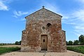
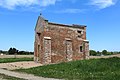
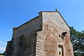
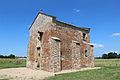
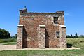
chapel located in Ain, in France  | |||||
| Upload media | |||||
| Instance of | |||||
|---|---|---|---|---|---|
| Location |
| ||||
| Street address |
| ||||
| Located on street | |||||
 | |||||
La chapelle est aussi connue sous le nom de chapelle Saint-André d'Aigrefeuille.
Media in category "Chapelle d'Aigrefeuille"
The following 19 files are in this category, out of 19 total.
-
 Chapelle Aigrefeuille 1.JPG 5,184 × 3,456; 7.29 MB
-
 Chapelle Aigrefeuille 2.JPG 5,184 × 3,456; 7.59 MB
-
 Chapelle Aigrefeuille 3.JPG 5,184 × 3,456; 8.07 MB
-
 Chapelle Aigrefeuille Bâgé Ville 1.jpg 5,184 × 3,456; 8.25 MB
-
 Chapelle Aigrefeuille Bâgé Ville 10.jpg 5,184 × 3,456; 9.01 MB
-
 Chapelle Aigrefeuille Bâgé Ville 11.jpg 3,456 × 5,184; 8.94 MB
-
 Chapelle Aigrefeuille Bâgé Ville 12.jpg 3,456 × 5,184; 8.83 MB
-
 Chapelle Aigrefeuille Bâgé Ville 13.jpg 5,184 × 3,456; 10.16 MB
-
 Chapelle Aigrefeuille Bâgé Ville 14.jpg 5,184 × 3,456; 7.61 MB
-
 Chapelle Aigrefeuille Bâgé Ville 15.jpg 5,184 × 3,456; 7.43 MB
-
 Chapelle Aigrefeuille Bâgé Ville 16.jpg 5,184 × 3,456; 9.19 MB
-
 Chapelle Aigrefeuille Bâgé Ville 17.jpg 5,184 × 3,456; 5.44 MB
-
 Chapelle Aigrefeuille Bâgé Ville 2.jpg 5,184 × 3,456; 11.23 MB
-
 Chapelle Aigrefeuille Bâgé Ville 3.jpg 5,184 × 3,456; 8.45 MB
-
 Chapelle Aigrefeuille Bâgé Ville 4.jpg 3,456 × 5,184; 10.9 MB
-
 Chapelle Aigrefeuille Bâgé Ville 5.jpg 5,184 × 3,456; 9.76 MB
-
 Chapelle Aigrefeuille Bâgé Ville 6.jpg 5,184 × 3,456; 8.79 MB
-
 Chapelle Aigrefeuille Bâgé Ville 8.jpg 3,456 × 5,184; 11.94 MB
-
 Chapelle Aigrefeuille Bâgé Ville 9.jpg 5,184 × 3,456; 10.51 MB


