Category:Chapelle des Pénitents rouges (Saorge)
Jump to navigation
Jump to search
| Object location | | View all coordinates using: OpenStreetMap |
|---|
|
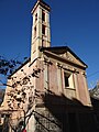
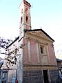
This building is inscrit au titre des monuments historiques de la France. It is indexed in the base Mérimée, a database of architectural heritage maintained by the French Ministry of Culture, under the reference PA00080854
|
chapel located in Alpes-Maritimes, in France  | |||||
| Upload media | |||||
| Instance of | |||||
|---|---|---|---|---|---|
| Location | Saorge, canton of Breil-sur-Roya | ||||
| Street address |
| ||||
| Architectural style | |||||
| Heritage designation |
| ||||
 | |||||
Chapelle Saint-Sébastien ou chapelle des Pénitents rouge, près de la mairie.
Media in category "Chapelle des Pénitents rouges (Saorge)"
The following 3 files are in this category, out of 3 total.
-
 La Roya Saorge Chapelle Penitents Rouges - panoramio.jpg 1,200 × 1,600; 701 KB
-
 Saorge - Chapelle des Pénitents rouges -01.JPG 3,672 × 4,896; 2.83 MB
-
 Saorge - Chapelle des Pénitents rouges -02.JPG 3,672 × 4,896; 2.55 MB

