Category:Chapelle du Rouet
Jump to navigation
Jump to search
| Object location | | View all coordinates using: OpenStreetMap |
|---|
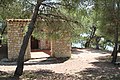
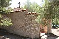
chapel located in Bouches-du-Rhône, in France  | |||||
| Upload media | |||||
| Instance of | |||||
|---|---|---|---|---|---|
| Location | Carry-le-Rouet, canton of Châteauneuf-Côte-Bleue | ||||
| Diocese | |||||
 | |||||
Media in category "Chapelle du Rouet"
The following 11 files are in this category, out of 11 total.
-
 Chapelle du Rouet 20180812 01.jpg 3,456 × 5,184; 9.29 MB
-
 Chapelle du Rouet 20180812 02.jpg 3,456 × 5,184; 5.66 MB
-
 Chapelle du Rouet 20180812 03.jpg 3,456 × 5,184; 13.43 MB
-
 Chapelle du Rouet 20180812 04.jpg 5,184 × 3,456; 12.46 MB
-
 Chapelle du Rouet 20180812 05.jpg 5,184 × 3,456; 12.48 MB
-
 Chapelle du Rouet 20180812 06.jpg 5,184 × 3,456; 10.17 MB
-
 Chapelle du Rouet 20180812 07.jpg 5,184 × 3,456; 11.2 MB
-
 Chapelle du Rouet 20180812 08.jpg 3,456 × 5,184; 12.39 MB
-
 Chapelle du Rouet 20180812 09.jpg 3,456 × 5,184; 8.18 MB
-
 Chapelle du Rouet 20180812 10.jpg 3,456 × 5,184; 9.1 MB
-
 Chapelle du Rouet.JPG 1,944 × 2,592; 1.92 MB


