Category:Chiricahua National Monument
Przejdź do nawigacji
Przejdź do wyszukiwania
national monument in southeastern Arizona  .jpg)  | |||||
| Prześlij plik multimedialny | |||||
| Jest to |
| ||||
|---|---|---|---|---|---|
| Część |
| ||||
| Miejsce | Hrabstwo Cochise, Arizona, Stany Zjednoczone | ||||
| Biuro informacji turystycznej |
| ||||
| Operator | |||||
| Status dobra kultury |
| ||||
| Kategoria obszaru chronionego IUCN | |||||
| Data utworzenia lub powstania |
| ||||
| oficjalna strona internetowa | |||||
 | |||||
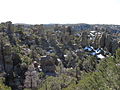
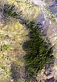
English: Chiricahua National Monument — located in the Chiricahua Mountains, in Cochise County, southeastern Arizona.
- The Madrean Sky Island landscape is famous for its extensive vertical rhyolite tuff type of Tuff rock formations.
- The Chiricahua National Monument Historic Designed Landscape and Faraway Ranch Historic District are within the National Monument (est. 1924), and are on the National Register of Historic Places in Cochise County.
- The park is surrounded by the Coronado National Forest.
Podkategorie
Poniżej wyświetlono 10 spośród wszystkich 10 podkategorii tej kategorii.
C
E
F
H
- Hoodoos in Chiricahua National Monument (34 pliki)
P
- Plants of Chiricahua National Monument (22 pliki)
S
T
Pliki w kategorii „Chiricahua National Monument”
Poniżej wyświetlono 50 spośród wszystkich 50 plików w tej kategorii.
-
 Arizona chiricahua national park 3.jpg 2448 × 3264; 1,15 MB
-
 Arizona chiricahua national park.jpg 3024 × 4032; 1,68 MB
-
 Arizona White Oak (653292bc-155d-451f-67a9-85e44a6f6d71).jpg 2048 × 3648; 3,59 MB
-
 AZ Chiricahua 1.jpg 4000 × 3000; 2,35 MB
-
 AZ Chiricahua 2.jpg 1746 × 1069; 548 KB
-
 AZ Chiricahua 3.jpg 2233 × 1282; 817 KB
-
 AZ Chiricahua 4.jpg 1973 × 1202; 703 KB
-
 Chiracahua national monument spires 1.JPG 3264 × 2448; 2,57 MB
-
 Chiricahua 001 L.D.jpg 1532 × 980; 1,69 MB
-
 Chiricahua Chiricahua National Monument HDR Panorama.jpg 1920 × 290; 538 KB
-
 Chiricahua map.jpg 544 × 784; 87 KB
-
 Chiricahua mountains and turkey creek caldera.jpg 3008 × 2000; 1,58 MB
-
 Chiricahua National Monument (29730123330).jpg 2448 × 2448; 3,46 MB
-
 Chiricahua National Monument Historic Designed Landscape - 20170318203141.jpg 7952 × 5304; 11,59 MB
-
 Chiricahua National Monument Historic Designed Landscape.jpg 2272 × 1704; 2,54 MB
-
 Chiricahua National Monument outcropping of rocks in black and white.jpg 2803 × 2504; 5,13 MB
-
 Chiricahua National Monument ridge of countless vertical rock formations.jpg 3240 × 4320; 15,48 MB
-
 Chiricahua National Monument rock formations framed by a living tree.jpg 3240 × 4320; 12,23 MB
-
 Chiricahua National Monument, Arizona (ba6a0fbc-3faa-4fcc-ac8c-78dcd81799c2).jpg 3072 × 2048; 862 KB
-
 Chiricahua National Monument, Arizona (d1866575-02f8-4a92-88dc-440769699f6e).jpg 3072 × 2048; 908 KB
-

-
 Chiricahua National Monument.jpg 3024 × 4032; 2,31 MB
-
 Chiricahua park99.jpg 1978 × 1727; 655 KB
-
 Chiricahuas in bloom.jpg 2930 × 4000; 7,34 MB
-
 Cochise Head rises above snowy hills. (64ce7cfc-155d-451f-67e5-065cc3e2017e).jpg 3648 × 2736; 5,6 MB
-
 Cochise's Head, Chiracahua National Monument - panoramio.jpg 2048 × 1536; 492 KB
-
 Fire Damage Horseshoe II Fire.jpg 720 × 540; 284 KB
-
 Forested Scene 2 (65290536-155d-451f-6766-8a66241a2286).jpg 3648 × 2048; 5,86 MB
-
 Grassland Chiricahua NM.jpg 2048 × 1536; 1,93 MB
-
 Horseshoe II Fire Damage Chiricahua NM.jpg 405 × 296; 117 KB
-
 InteriorChaparral 1 (15748026617).jpg 1024 × 768; 772 KB
-
 InteriorChaparral 4 (15933727285).jpg 3224 × 2736; 4,33 MB
-
 Jesse James Canyon, Chiricahua NM.jpg 720 × 540; 363 KB
-
 Peak in snow (651e4539-155d-451f-676f-bc4438e03c1a).jpg 3648 × 2048; 4,74 MB
-
 Piñon pine needles with snow (652e1763-155d-451f-6724-96bd531b4ef3).jpg 3648 × 2048; 3,91 MB
-
 Rime on Dead Branch (65028a44-155d-451f-6771-3bbc39378347).jpg 3648 × 2736; 3,62 MB
-
 Rime on Forest (64df5ed7-155d-451f-6779-1615ce33e962).jpg 3648 × 2736; 5,96 MB
-
 Rime on Juniper (64f7e3b2-155d-451f-6760-693b3214bafc).jpg 3648 × 2736; 4,24 MB
-
 Rime on Manzanita (64f27f97-155d-451f-6785-ac1239ff8658).jpg 3648 × 2736; 4 MB
-
 Rime on Pine (64da8e2f-155d-451f-67fb-c75d9269a6ab).jpg 3648 × 2736; 3,85 MB
-
 Rime on Pine 2 (64fcd712-155d-451f-67a8-3524175e4633).jpg 3648 × 2736; 4,77 MB
-
 Schott's Yuccas (6523a7af-155d-451f-6714-f5a495b2f8a3).jpg 3648 × 2048; 5,56 MB
-
 Semidesert 1 (15747529069).jpg 2272 × 1704; 2,97 MB
-
 Snow Capped Boulder (651880d8-155d-451f-67ba-7990c5c87642).jpg 3648 × 2048; 5,56 MB
-
 Snow Capped Rocks (6512be24-155d-451f-67d7-7d568076ee6d).jpg 3648 × 2736; 5,48 MB
-
 Snow covered agave (650d62e6-155d-451f-67c0-8de7913ea43a).jpg 3648 × 2736; 3,94 MB
-
 Snow covered rhyolite columns (64d411a1-155d-451f-671c-3c08a602193c).jpg 3648 × 2736; 5,91 MB
-
 Snowy view from campground (6536a910-155d-451f-67d4-41539b0ebefa).jpg 3648 × 2048; 4,21 MB
-
 TemperateForest 2 (15750918718).jpg 2560 × 1920; 3,38 MB
-
 Volunteers Help Out (65079c7a-155d-451f-67cf-c955d5150323).jpg 3648 × 2736; 4,97 MB


.jpg)


.jpg)


.jpg)
.jpg)
_(18101285765).jpg)


.jpg)


.jpg)


.jpg)

.jpg)
.jpg)
.jpg)
.jpg)
.jpg)
.jpg)
.jpg)
.jpg)
.jpg)
.jpg)
.jpg)
.jpg)
.jpg)
.jpg)
.jpg)
.jpg)
.jpg)
Kategorie:
- National Monuments of Arizona
- National Monuments of the United States by name
- Rock formations in Arizona
- Tuff rock formations
- Chiricahua Mountains
- Protected areas of Cochise County, Arizona
- Madrean Sky Islands
- 1924 establishments in the United States
- 1924 in Arizona
- Historic districts on the National Register of Historic Places in Arizona
- National Register of Historic Places in Cochise County, Arizona
- Rhyolite formations in the United States
- Volcanic landforms in Arizona
- Tuff rock formations in Arizona
- Locations along Arizona State Route 181
- Oligocene caldera forming eruptions
- Oligocene volcanism of Arizona
- Rhyolite Canyon Tuff
- National Park Service in Arizona
- Protected areas established in 1924
- IUCN Category V
- IUCN Protected areas of the United States