Category:Church in Carmzow
Jump to navigation
Jump to search
| Object location | | View all coordinates using: OpenStreetMap |
|---|
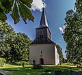
church building in Uckermark district, Brandenburg state, Germany  | |||||
| Upload media | |||||
| Instance of | |||||
|---|---|---|---|---|---|
| Location | Carmzow, Carmzow-Wallmow, Amt Brüssow, Uckermark District, Brandenburg, Germany | ||||
| Heritage designation | |||||
 | |||||
This is the category of the Brandenburger Baudenkmal (cultural heritage monument) with the ID 09130025 (Wikidata)
|
English: Pictures of the church in Carmzow, Carmzow-Wallmow municipality, Uckermark district, Brandenburg state, Germany
Deutsch: Bilder der Kirche in Carmzow, Gemeinde Carmzow-Wallmow, Landkreis Uckermark, Land Brandenburg, Deutschland.
Français : Photos de l'église à Carmzow, commune de Carmzow-Wallmow, arrondissement de Uckermark, état fédéral de Brandebourg, Allemagne
Media in category "Church in Carmzow"
The following 9 files are in this category, out of 9 total.
-
 Carmzow 08 17 03-2 jiw.jpg 1,920 × 1,752; 940 KB
-
 Dorfkirche Carmzow Nordansicht.jpg 3,024 × 4,032; 5.48 MB
-
 Dorfkirche Carmzow Nordostansicht.jpg 3,024 × 4,032; 3.97 MB
-
 Dorfkirche Carmzow Ostansicht.jpg 3,024 × 4,032; 5.6 MB
-
 Dorfkirche Carmzow Südansicht.jpg 3,024 × 4,032; 4.22 MB
-
 Dorfkirche Carmzow Südwestansicht.jpg 3,024 × 4,032; 4.62 MB
-
 Dorfkirche Carmzow Westansicht mit Einfriedung.png 3,024 × 3,621; 15.29 MB
-
 Dorfkirche Carmzow Westansicht.jpg 3,024 × 4,032; 3.67 MB
-
 Dorfkirche Carmzow Westportal.jpg 4,032 × 3,024; 5.05 MB


