Category:Church in Gersdorf (Falkenberg)
Jump to navigation
Jump to search
| Object location | | View all coordinates using: OpenStreetMap |
|---|
_2018_ESE.jpg) | |||||
| Upload media | |||||
| Instance of | |||||
|---|---|---|---|---|---|
| Location | Kruge/Gersdorf, Falkenberg, Märkisch-Oderland District, Brandenburg, Germany | ||||
| Heritage designation | |||||
 | |||||
This is the category of the Brandenburger Baudenkmal (cultural heritage monument) with the ID 09180497 (Wikidata)
|
English: Pictures of the church in Gersdorf, Falkenberg municipality, Märkisch-Oderland district, Brandenburg state, Germany
Deutsch: Bilder der Kirche in Gersdorf, Gemeinde Falkenberg, Landkreis Märkisch-Oderland, Land Brandenburg, Deutschland.
Français : Photos de l'église à Gersdorf, commune de Falkenberg, arrondissement de Märkisch-Oderland, état fédéral de Brandebourg, Allemagne
Media in category "Church in Gersdorf (Falkenberg)"
The following 10 files are in this category, out of 10 total.
-
 Dorfkirche Gersdorf (Falkenberg) 2018 ESE.jpg 5,052 × 4,290; 14.07 MB
-
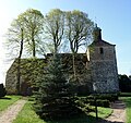 Dorfkirche Gersdorf (Falkenberg) 2018 N.jpg 4,948 × 4,640; 11.25 MB
-
 Dorfkirche Gersdorf (Falkenberg) 2018 NE.jpg 4,504 × 4,523; 10.86 MB
-
 Dorfkirche Gersdorf (Falkenberg) 2018 NW.jpg 3,648 × 4,864; 7.09 MB
-
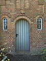 Dorfkirche Gersdorf (Falkenberg) 2018 Portal N.jpg 3,648 × 4,864; 5.25 MB
-
 Dorfkirche Gersdorf (Falkenberg) 2018 Portal W.jpg 3,624 × 4,846; 7.23 MB
-
 Dorfkirche Gersdorf (Falkenberg) 2018 S.jpg 6,175 × 4,500; 16.04 MB
-
 Dorfkirche Gersdorf (Falkenberg) 2018 SSE.jpg 4,780 × 4,228; 12.95 MB
-
 Dorfkirche Gersdorf (Falkenberg) 2018 Turm.jpg 3,648 × 4,864; 6.52 MB
-
 Dorfkirche Gersdorf (Falkenberg) 2018 Turmhaube.jpg 3,648 × 4,864; 5.73 MB
_2018_N.jpg)
_2018_NE.jpg)
_2018_NW.jpg)
_2018_Portal_N.jpg)
_2018_Portal_W.jpg)
_2018_S.jpg)
_2018_SSE.jpg)
_2018_Turm.jpg)
_2018_Turmhaube.jpg)