Category:Church in Hohenlandin
Jump to navigation
Jump to search
| Object location | | View all coordinates using: OpenStreetMap |
|---|
 | |||||
| Upload media | |||||
| Instance of | |||||
|---|---|---|---|---|---|
| Location | Hohenlandin, Mark Landin, Schwedt/Oder, Uckermark District, Brandenburg, Germany | ||||
| Heritage designation | |||||
 | |||||
This is the category of the Brandenburger Baudenkmal (cultural heritage monument) with the ID 09130535 (Wikidata)
|
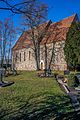
English: Church in Hohenlandin, Schwedt/Oder municipality, Uckermark district, Brandenburg state, Germany
Deutsch: Kirche in Hohenlandin, Gemeinde Schwedt/Oder, Landkreis Uckermark, Land Brandenburg, Deutschland.
Français : Église de Hohenlandin, commune de Schwedt/Oder, arrondissement Uckermark, état fédéral de Brandebourg, Allemagne
Media in category "Church in Hohenlandin"
The following 3 files are in this category, out of 3 total.
-
 Hohenlandin 02 12 09 jiw.jpg 2,000 × 3,000; 2.4 MB
-
 Hohenlandin 02 12 09.jpg 2,000 × 2,828; 2.03 MB
-
 Hohenlandin 06 15 05 jiw.jpg 1,800 × 1,201; 672 KB

