Category:Church in Kunersdorf (Bliesdorf)
Jump to navigation
Jump to search
| Object location | | View all coordinates using: OpenStreetMap |
|---|
This is the category of the Brandenburger Baudenkmal (cultural heritage monument) with the ID 09180499 (Wikidata)
|
church building in Brandenburg state, Germany  | |||||
| Upload media | |||||
| Instance of | |||||
|---|---|---|---|---|---|
| Location | Kunersdorf, Bliesdorf, Märkisch-Oderland District, Brandenburg, Germany | ||||
| Architect | |||||
| Heritage designation | |||||
| Inception |
| ||||
 | |||||
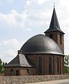
Deutsch: Bilder der Kirche in Kunersdorf , Gemeinde Bliesdorf, Landkreis Märkisch-Oderland, Land Brandenburg, Deutschland. Sie gehört und dient einer Gemeinde der unierten Evangelischen Kirche Berlin-Brandenburg-Schlesische Oberlausitz. Der Vorgängerbau von 1781 wurde 1945 zerstört, die jetzige Kirche entstand 1951–1955.
English: Pictures of the church in Kunersdorf , Bliesdorf municipality, Märkisch-Oderland district, Brandenburg state, Germany. It is owned and used by a congregation within the Evangelical Church of Berlin-Brandenburg-Silesian Upper Lusatia, a united Protestant church body of Calvinist, Lutheran and united congregations. The predecessor of 1781 was destroyed in 1945, the current structure was erected between 1951 and 1955.
Français : Photos de l'église à Kunersdorf , commune de Bliesdorf, arrondissement de Märkisch-Oderland, état fédéral de Brandebourg, Allemagne
Media in category "Church in Kunersdorf (Bliesdorf)"
The following 28 files are in this category, out of 28 total.
-
 Dorfkirche Kunersdorf (Bliesdorf) 2015 Fenster.jpg 2,688 × 1,520; 2 MB
-
 Dorfkirche Kunersdorf (Bliesdorf) 2015 NNW.jpg 1,451 × 1,801; 821 KB
-
 Dorfkirche Kunersdorf (Bliesdorf) 2015 SSW.jpg 1,520 × 2,241; 1.38 MB
-
 Dorfkirche Kunersdorf (Bliesdorf) 2015 W.jpg 2,552 × 1,888; 2.03 MB
-
 Dorfkirche Kunersdorf Bliesdorf 2016 01.jpg 6,016 × 4,000; 11.16 MB
-
 Dorfkirche Kunersdorf Bliesdorf 2016 02.jpg 6,016 × 4,000; 11.72 MB
-
 Dorfkirche Kunersdorf Bliesdorf 2016 03.jpg 6,016 × 4,000; 12.98 MB
-
 Dorfkirche Kunersdorf Bliesdorf 2016 04.jpg 6,016 × 4,000; 10.63 MB
-
 Dorfkirche Kunersdorf Bliesdorf 2016 05.jpg 6,016 × 4,000; 10.12 MB
-
 Dorfkirche Kunersdorf Bliesdorf 2016 06.jpg 6,016 × 4,000; 10.34 MB
-
 Dorfkirche Kunersdorf Bliesdorf 2016 07.jpg 6,016 × 4,000; 12.4 MB
-
 Dorfkirche Kunersdorf Bliesdorf.jpg 3,792 × 2,492; 6.08 MB
-
 Kunersdorf 2018 001.jpg 3,264 × 2,448; 2.3 MB
-
 Kunersdorf 2018 005.jpg 3,264 × 2,448; 2.6 MB
-
 Kunersdorf 2018 006.jpg 3,264 × 2,448; 2.64 MB
-
 Kunersdorf 2018 007.jpg 3,264 × 2,448; 2.83 MB
-
 Kunersdorf 2018 008.jpg 3,264 × 2,448; 3.41 MB
-
 Kunersdorf 2018 009.jpg 2,448 × 3,264; 2.78 MB
-
 Kunersdorf 2018 010.jpg 3,264 × 2,448; 2.24 MB
-
 Kunersdorf 2018 011.jpg 3,264 × 2,448; 2.18 MB
-
 Kunersdorf 2018 041.jpg 3,264 × 2,448; 3 MB
-
 Kunersdorf 2018 042.jpg 3,264 × 2,448; 3.26 MB
-
 Kunersdorf 2018 043.jpg 2,448 × 3,264; 2.21 MB
-
 Kunersdorf 2018 044.jpg 3,264 × 2,448; 2.56 MB
-
 Kunersdorf 2018 045.jpg 2,448 × 3,264; 3.11 MB
-
 Kunersdorf 2018 046.jpg 3,264 × 2,448; 3.65 MB
-
 Kunersdorf church S.jpg 1,320 × 1,740; 252 KB
-
 Kunersdorf church.jpg 1,170 × 1,410; 177 KB
_2015_Fenster.jpg)
_2015_NNW.jpg)
_2015_SSW.jpg)
_2015_W.jpg)


