Category:Church in Leuenberg
Jump to navigation
Jump to search
| Object location | | View all coordinates using: OpenStreetMap |
|---|
 | |||||
| Upload media | |||||
| Instance of | |||||
|---|---|---|---|---|---|
| Location | Q117067639, Höhenland, Märkisch-Oderland District, Brandenburg, Germany | ||||
| Heritage designation | |||||
 | |||||
This is the category of the Brandenburger Baudenkmal (cultural heritage monument) with the ID 09180509 (Wikidata)
|
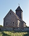
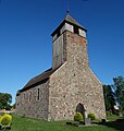
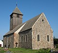
English: Pictures of the church in Leuenberg, Höhenland municipality, Märkisch-Oderland district, Brandenburg state, Germany
Deutsch: Bilder der Kirche in Leuenberg, Gemeinde Höhenland, Landkreis Märkisch-Oderland, Land Brandenburg, Deutschland.
Français : Photos de l'église à Leuenberg, commune de Höhenland, arrondissement de Märkisch-Oderland, état fédéral de Brandebourg, Allemagne
Media in category "Church in Leuenberg"
The following 8 files are in this category, out of 8 total.
-
 Dorfkirche Leuenberg 2018 ENE.jpg 3,112 × 3,934; 4.69 MB
-
 Dorfkirche Leuenberg 2018 NE.jpg 4,683 × 3,663; 6.1 MB
-
 Dorfkirche Leuenberg 2018 NW.jpg 4,528 × 4,751; 7.95 MB
-
 Dorfkirche Leuenberg 2018 SW.jpg 3,648 × 4,864; 5.3 MB
-
 Dorfkirche Leuenberg 2018 Südportal.jpg 4,798 × 3,558; 7.14 MB
-
 Dorfkirche Leuenberg 2018 Westportal.jpg 3,648 × 3,836; 8.25 MB
-
 KircheLeuenbergSüdansicht.jpg 4,000 × 3,000; 4.62 MB
-
 Leuenberg church.jpg 2,496 × 2,272; 705 KB


