Category:Church in Liebenberg
Jump to navigation
Jump to search
| Object location | | View all coordinates using: OpenStreetMap |
|---|
church building in Brandenburg state, Germany   | |||||
| Upload media | |||||
| Instance of | |||||
|---|---|---|---|---|---|
| Location | Liebenberg, Löwenberger Land, Oberhavel District, Brandenburg, Germany | ||||
| Heritage designation | |||||
 | |||||
This is the category of the Brandenburger Baudenkmal (cultural heritage monument) with the ID 09165176 (Wikidata)
|
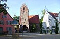
English: Church in Liebenberg, Löwenberger Land municipality, Oberhavel district, Brandenburg state, Germany
Deutsch: Dorfkirche Liebenberg, Gemeinde Löwenberger Land, Landkreis Oberhavel, Land Brandenburg, Deutschland
Français : Église de Liebenberg, commune de Löwenberger Land, arrondissement de Haute-Havel, état fédéral de Brandebourg, Allemagne
Subcategories
This category has only the following subcategory.
I
Media in category "Church in Liebenberg"
The following 10 files are in this category, out of 10 total.
-
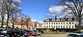 20120408140MDR Liebenberg (Löwenberger Land) Schloß.jpg 3,984 × 1,752; 7.58 MB
-
 20120408180DR Liebenberg (Löwenberger Land) Brunnen Kirche.jpg 2,348 × 1,755; 4.03 MB
-
 20120408190MDR Liebenberg (Löwenberger Land) Kirche.jpg 1,721 × 2,321; 4.04 MB
-
 20120408200DR Liebenberg (Löwenberger Land) Kirche Wappen.jpg 1,534 × 2,121; 3.95 MB
-
 20120408210DR Liebenberg (Löwenberger Land) Kirche Gruft.jpg 2,464 × 1,826; 5 MB
-
 Church Liebenberg.JPG 1,312 × 1,984; 1.58 MB
-
 Liebenberg Dorfkirche lub 2022-12-29 img01.jpg 4,032 × 3,024; 9.76 MB
-
 Liebenberg Dorfkirche lub 2022-12-29 img02.jpg 3,024 × 4,032; 5.98 MB
-
 Liebenberg Schlosshof und Schlosskirche.JPG 1,520 × 1,889; 591 KB
-
 Liebenberg Schlosshof.JPG 1,632 × 1,070; 428 KB
_Schlo%C3%9F.jpg)
_Brunnen_Kirche.jpg)
_Kirche.jpg)
_Kirche_Wappen.jpg)
_Kirche_Gruft.jpg)


