Category:Church in Wollin (Randowtal)
Jump to navigation
Jump to search
| Object location | | View all coordinates using: OpenStreetMap |
|---|
 | |||||
| Upload media | |||||
| Instance of | |||||
|---|---|---|---|---|---|
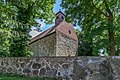
| Location | Wollin (Randowtal), Randowtal, Uckermark District, Brandenburg, Germany | ||||
| Heritage designation | |||||
 | |||||
This is the category of the Brandenburger Baudenkmal (cultural heritage monument) with the ID 09130038 (Wikidata)
|
Français : Église de Wollin, commune de Randowtal, arrondissement Uckermark, état fédéral de Brandebourg, Allemagne
Media in category "Church in Wollin (Randowtal)"
This category contains only the following file.
-
 Wollin 07 17 03 jiw.jpg 1,920 × 1,280; 1.01 MB