Category:Church in Woltersdorf (Casekow)
Jump to navigation
Jump to search
| Object location | | View all coordinates using: OpenStreetMap |
|---|
church building in Brandenburg state, Germany _2019_SE.jpg) | |||||
| Upload media | |||||
| Instance of | |||||
|---|---|---|---|---|---|
| Location | Woltersdorf (Casekow), Casekow, Uckermark District, Brandenburg, Germany | ||||
| Heritage designation | |||||
 | |||||
This is the category of the Brandenburger Baudenkmal (cultural heritage monument) with the ID 09130757 (Wikidata)
|
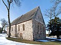
English: Church in Woltersdorf, Casekow municipality, Uckermark district, Brandenburg state, Germany
Deutsch: Kirche in Woltersdorf, Gemeinde Casekow, Landkreis Uckermark, Land Brandenburg, Deutschland.
Français : Église de Woltersdorf, commune de Casekow, arrondissement Uckermark, état fédéral de Brandebourg, Allemagne
Media in category "Church in Woltersdorf (Casekow)"
The following 11 files are in this category, out of 11 total.
-
 Dorfkirche Woltersdorf (Casekow) 2019 Glockenschauer E.jpg 3,648 × 4,864; 6.4 MB
-
 Dorfkirche Woltersdorf (Casekow) 2019 Glockenschauer SE.jpg 3,648 × 4,864; 8.77 MB
-
 Dorfkirche Woltersdorf (Casekow) 2019 NNE.jpg 5,990 × 3,894; 9.39 MB
-
 Dorfkirche Woltersdorf (Casekow) 2019 NNW.jpg 5,437 × 3,596; 10.83 MB
-
 Dorfkirche Woltersdorf (Casekow) 2019 S.jpg 5,024 × 3,586; 9.48 MB
-
 Dorfkirche Woltersdorf (Casekow) 2019 SE.jpg 4,732 × 4,118; 8.83 MB
-
 Dorfkirche Woltersdorf (Casekow) 2019 Südostportal.jpg 4,864 × 3,648; 7.64 MB
-
 Dorfkirche Woltersdorf (Casekow) 2019 Südwestportal.jpg 3,648 × 4,864; 7.29 MB
-
 Dorfkirche Woltersdorf (Casekow) 2019 vermauertes Nordportal.jpg 3,648 × 4,864; 7.11 MB
-
 Dorfkirche Woltersdorf (Casekow) 2019 W.jpg 4,627 × 4,528; 11.09 MB
-
 Kirche, Woltersdorf (Casekow).jpg 4,373 × 3,191; 8.93 MB
_2019_Glockenschauer_E.jpg)
_2019_Glockenschauer_SE.jpg)
_2019_NNE.jpg)
_2019_NNW.jpg)
_2019_S.jpg)
_2019_S%C3%BCdostportal.jpg)
_2019_S%C3%BCdwestportal.jpg)
_2019_vermauertes_Nordportal.jpg)
_2019_W.jpg)
.jpg)