Category:Church of St James, Long Marston
Jump to navigation
Jump to search
| Object location | | View all coordinates using: OpenStreetMap |
|---|
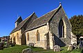
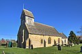
Grade I listed church, Stratford-on-Avon, United Kingdom  | |||||
| Upload media | |||||
| Instance of | |||||
|---|---|---|---|---|---|
| Dedicated to | |||||
| Location | Long Marston, Stratford-on-Avon, Warwickshire, West Midlands, England | ||||
| Diocese | |||||
| Heritage designation |
| ||||
| Inception |
| ||||
| Religion or worldview | |||||
 | |||||
Media in category "Church of St James, Long Marston"
The following 12 files are in this category, out of 12 total.
-

-
 Benchmark on St James Church - geograph.org.uk - 4102325.jpg 685 × 1,024; 331 KB
-
 Church of St James the Great at Long Marston - geograph.org.uk - 6245228.jpg 576 × 1,024; 151 KB
-
 Church of St James The Great, Long Marston - geograph.org.uk - 4352121.jpg 2,000 × 1,276; 939 KB
-
 Church of St James The Great, Long Marston - geograph.org.uk - 4352140.jpg 2,000 × 1,305; 924 KB
-
 Church of St James The Great, Long Marston - geograph.org.uk - 4352158.jpg 2,000 × 1,325; 1.09 MB
-
 Long Marston Church - geograph.org.uk - 1982748.jpg 640 × 480; 92 KB
-
 Long Marston Church - geograph.org.uk - 55852.jpg 640 × 480; 178 KB
-
 Long Marston Church - geograph.org.uk - 6166887.jpg 1,600 × 1,200; 562 KB
-
 Porch, Long Marston Church - geograph.org.uk - 1982749.jpg 480 × 640; 107 KB
-
 St James the Great, Long Marston - geograph.org.uk - 6248669.jpg 1,024 × 768; 229 KB
-
 St James's Church - geograph.org.uk - 4022591.jpg 1,024 × 683; 184 KB


