Category:Clausthal-Zellerfeld
Vai alla navigazione
Vai alla ricerca

city in Lower Saxony, Germany .jpg)   | |||||
| Carica un file multimediale | |||||
| Istanza di |
| ||||
|---|---|---|---|---|---|
| Luogo |
| ||||
| Ufficio turistico |
| ||||
| Capo del governo | |||||
| Popolazione |
| ||||
| Superficie |
| ||||
| Altezza sul mare |
| ||||
| Ha sostituito | |||||
| sito web ufficiale | |||||
 | |||||
Deutsch: Clausthal-Zellerfeld ist eine Bergstadt in der Samtgemeinde Oberharz im Landkreis Goslar, Niedersachsen, Deutschland.
Sottocategorie
Questa categoria contiene le 19 sottocategorie indicate di seguito, su un totale di 19.
B
C
E
- Elisabether Graben (5 F)
F
H
- Hornbach (Zellbach) (2 F)
M
N
P
S
- Sealing stamps of Clausthal (13 F)
W
Z
File nella categoria "Clausthal-Zellerfeld"
Questa categoria contiene 82 file, indicati di seguito, su un totale di 82.
-
 Wappen Clausthal-Zellerfeld.png 497 × 562; 546 KB
-
 01547 DEU Schulenberg mountain biking.jpg 2 965 × 2 965; 2,65 MB
-
 V4 pg69 Clausthal.jpg 2 171 × 1 367; 2,03 MB
-
 2021-12-20 Eschenbacher Flutgraben.jpg 960 × 1 280; 1,04 MB
-
 Adolf-Ey-Straße 2.jpg 2 048 × 1 536; 1,41 MB
-
 Adolph-Roemer-Straße 37 - Stall.jpg 2 048 × 1 536; 1,37 MB
-
 Adolph-Roemer-Straße 9 Stall.jpg 2 048 × 1 536; 1,41 MB
-
 Altenau Feuerwehr.jpg 3 000 × 4 000; 3,14 MB
-
 Altenauer 18.jpg 2 048 × 1 536; 1,4 MB
-
 Altenauer 41.jpg 2 048 × 1 536; 1,42 MB
-
 Altenauer Straße 8.jpg 2 048 × 1 536; 1,44 MB
-
 Andreastaler 01.jpg 5 900 × 3 000; 9,34 MB
-
 Aulastraße 1-3.jpg 2 048 × 1 536; 1,35 MB
-
 Aulastraße 2.jpg 2 048 × 1 536; 1,42 MB
-
 Aulastraße 4.jpg 2 048 × 1 536; 1,38 MB
-
 Bergbausymbol clausthal1.jpg 2 598 × 2 125; 462 KB
-
 Bergstraße 30, Zellerfeld.jpg 2 048 × 1 536; 1,41 MB
-
 Bergstraße 33.jpg 2 048 × 1 536; 1,39 MB
-
 Bergstraße 37.jpg 2 048 × 1 536; 1,41 MB
-
 Bergstraße 39.jpg 2 048 × 1 536; 1,38 MB
-
 BockwieserHoehePano.jpg 32 109 × 2 816; 22,08 MB
-
 Buntenbock-Luftaufnahme-01.jpg 3 216 × 2 136; 6,71 MB
-
 Buntenböcker 12.jpg 2 048 × 1 536; 1,38 MB
-
 Buntenböcker 18.jpg 2 048 × 1 536; 1,42 MB
-
 Buntenböcker 22.jpg 2 048 × 1 536; 1,41 MB
-
 Buntenböcker 24.jpg 2 048 × 1 536; 1,36 MB
-
 Buntenböcker 40.jpg 2 048 × 1 536; 1,42 MB
-
 Buntenböcker Straße14.jpg 2 048 × 1 536; 1,44 MB
-
 Clausthal memory.jpg 4 032 × 3 024; 10 MB
-
 Clausthal-Zellerfeld-Luftaufnahme-01.jpg 3 216 × 2 136; 7,35 MB
-
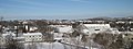 Clausthal-Zellerfeld.jpg 4 608 × 1 735; 1,64 MB
-
 Creativ-art Pfad Clausthal-Zellerfeld.JPG 4 608 × 3 456; 5,58 MB
-
 Dammgraben Sperberhaierdamm.jpg 3 760 × 2 740; 4,89 MB
-
 DCHF7106.jpg 3 137 × 3 023; 2,21 MB
-
De-Clausthal-Zellerfeld.oga 1,6 s; 20 KB
-
De-Clausthal-Zellerfeld.ogg 2,7 s; 26 KB
-
De-Clausthal.oga 1,1 s; 15 KB
-
DE-Zellbach.ogg 0,7 s; 12 KB
-
 Dennert-Tanne (Clausthal-Zellerfeld).jpg 2 144 × 1 424; 2,18 MB
-
-
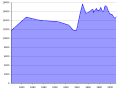
 Einwohnerentwicklung von Clausthal-Zellerfeld.svg 800 × 400; 58 KB
-
 Farn im Gegenlicht.jpg 4 608 × 3 456; 3,83 MB
-
 Flight in Clausthal-Zellerfeld.jpg 4 608 × 3 456; 3,64 MB
-
 Harz-Berg-Kalender 1935 - CLZ Stadtwappen Seite 17.svg 2 340 × 2 324; 291 KB
-
 Heather3.jpg 4 608 × 3 456; 3,61 MB
-
 Hirschler Teich Luftbild.jpg 3 072 × 2 048; 401 KB
-
 Holzhäuser Claustahl-Zellerfeld 1.jpg 3 720 × 2 520; 2,69 MB
-
 Holzhäuser Claustahl-Zellerfeld 5.jpg 3 796 × 2 768; 3,23 MB
-
 Holzhäuser Clausthal-Zellerfeld 2.jpg 3 951 × 2 883; 2,68 MB
-
 Holzhäuser Clausthal-Zellerfeld 3.jpg 3 684 × 2 760; 3,92 MB
-
 Holzhäuser Clausthal-Zellerfeld 4.jpg 2 656 × 2 656; 1,82 MB
-
 Holzhäuser Clausthal-Zellerfeld 6.jpg 2 760 × 3 684; 2,69 MB
-
 Holzhäuser Clausthal-Zellerfeld 7.jpg 3 654 × 2 690; 3,62 MB
-
 InnersteClausthal.jpg 1 024 × 768; 270 KB
-
 Innovationspark Tannenhöhe Clausthal-Zellerfeld.jpg 2 378 × 1 782; 1,22 MB
-
 Jägersbleeker Graben Tränkergraben 1.jpg 3 684 × 2 760; 5 MB
-
 Karte des Harzes von Diercke und Gaebler (6).jpg 2 665 × 2 186; 4,86 MB
-
 Merian 1650 Causthal.jpg 1 429 × 437; 132 KB
-
 Merian 1650 Clausthal - Teilansicht Kirche Clausthal.jpg 632 × 354; 108 KB
-
 Merian Clausthal - Teilansicht Kirche Clausthal.jpg 1 069 × 600; 249 KB
-
 Merian Clausthal.JPG 3 208 × 1 836; 1,68 MB
-
 Minigolf Clausthal-Zellerfeld.jpg 3 684 × 2 760; 3,77 MB
-
 Morgenbrodstaler Graben.JPG 1 024 × 1 360; 303 KB
-
 CLAUSTHAL ZELLERFELD nieder.svg 512 × 427; 21 KB
-
 POLSTERBERG nieder.svg 512 × 427; 21 KB
-
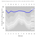
 Population Statistics Clausthal-Zellerfeld.png 939 × 570; 17 KB
-
 Population Statistics Clausthal-Zellerfeld.svg 800 × 600; 11 KB
-
 PSV Batl 800.jpg 300 × 381; 74 KB
-
 Pulverhaus Dorotheer (2).jpg 2 048 × 1 536; 1,41 MB
-
 Pulverhaus Dorotheer (3).jpg 2 048 × 1 536; 1,39 MB
-
 SchalkeStadtwegerTeich.jpg 3 853 × 2 167; 1,31 MB
-
 Schießstand Oberharz-Kaserne Clausthal-Zellerfeld.jpg 4 032 × 1 816; 4,7 MB
-
 Seigerriss Rosenhöfer Gangzug nach Buschendorf et al. 1971.png 1 230 × 897; 567 KB
-
 Special Karte vom Ober- und Unter-Harz von Henry Lange (11).jpg 1 049 × 919; 951 KB
-
 Stall Buntenböcker 20.jpg 2 048 × 1 536; 1,43 MB
-
 Stall Buntenböcker 50.jpg 2 048 × 1 536; 1,37 MB
-
 UHasenbAL.JPG 1 536 × 2 048; 1 013 KB
-
 Windenstart apr1987.jpg 756 × 460; 39 KB
-
 WL-Aufffahrung.JPG 1 890 × 1 192; 1,22 MB
-
 Zellerfeld (Merian).jpg 1 783 × 541; 228 KB
-
 ZellerfelderTalWest.jpg 15 534 × 3 155; 12,87 MB
-
 Zufahrt Oberharz-Kaserne Clausthal-Zellerfeld.jpg 3 653 × 1 816; 2,32 MB


.jpg)
.png)


.jpg)


.jpg)
.jpg)


.jpg)


.jpg)