Category:Closeburn, Dumfries and Galloway
Aller à la navigation
Aller à la recherche
village au Royaume-Uni  | |||||
| Téléverser des médias | |||||
| Nature de l’élément | |||||
|---|---|---|---|---|---|
| Lieu |
| ||||
 | |||||
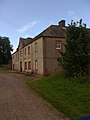
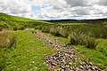
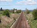
English: Closeburn is a village and civil parish in Dumfries and Galloway, Scotland. The village is on the A76 road south of Thornhill. In the 2001 census, Closeburn had a population of 1,119,
Sous-catégories
Cette catégorie comprend 6 sous-catégories, dont les 6 ci-dessous.
B
- Barburgh Mill (3 F)
- Brownhill Inn (12 F)
C
- Capel Burn (5 F)
- Closeburn Castle (5 F)
- Closeburn railway station (3 F)
Média dans la catégorie « Closeburn, Dumfries and Galloway »
Cette catégorie comprend 144 fichiers, dont les 144 ci-dessous.
-
 A bridge over the Garroch Water - geograph.org.uk - 376580.jpg 640 × 480 ; 101 kio
-
 A man and his dogs, near Auldgirth - geograph.org.uk - 662050.jpg 480 × 640 ; 66 kio
-
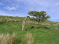 A wind shaped oak tree on Linnburn Hill - geograph.org.uk - 435460.jpg 640 × 480 ; 116 kio
-
 Barraby Wood - geograph.org.uk - 405227.jpg 640 × 481 ; 90 kio
-
 Blackwood House - geograph.org.uk - 925537.jpg 640 × 480 ; 60 kio
-
 Blawplain Farm - geograph.org.uk - 376833.jpg 640 × 480 ; 105 kio
-
 Bottom of the Strip - geograph.org.uk - 728067.jpg 640 × 480 ; 111 kio
-
 Boulders in Glenbuith streamway - geograph.org.uk - 1407297.jpg 640 × 425 ; 135 kio
-
 Bridge Over Pothole Burn - geograph.org.uk - 731623.jpg 640 × 480 ; 138 kio
-
 Brownhill Inn and railway from Kirkpatrick railway overbridge, Closeburn, Dumfries & Galloway.jpg 4 602 × 3 090 ; 6,57 Mio
-
 Brownhill Inn, Closeburn - gable end view of the steading and old inn.jpg 4 462 × 2 708 ; 4,65 Mio
-
 Brownhill Inn, Closeburn - view from the railway overbridge.jpg 4 520 × 3 336 ; 5,48 Mio
-
 Brownhill Inn, Closeburn - view of the Brownhill Steading - the later farm buildings.jpg 3 842 × 2 557 ; 3,74 Mio
-
 Brownhill Inn, Closeburn - view of the cart shed extension and owl hole.jpg 3 689 × 2 586 ; 3,76 Mio
-
 Brownhill Inn, Closeburn - view of the cart sheds.jpg 4 126 × 2 380 ; 3,81 Mio
-
 Brownhill Inn, Closeburn - view of the gable end of the steading.jpg 3 821 × 2 855 ; 3,97 Mio
-
 Brownhill Inn, Closeburn - view of the old inn site and the stables, etc to the left.jpg 4 229 × 2 624 ; 5,46 Mio
-
 Brownhill Inn, Closeburn - view of the steading and old stables, coach house, etc.jpg 4 608 × 2 466 ; 4,09 Mio
-
 Cairn at the Southern End of the Summit - geograph.org.uk - 600761.jpg 640 × 427 ; 43 kio
-
 Cairn Farm - geograph.org.uk - 435435.jpg 631 × 466 ; 105 kio
-
 Cairn Farm - geograph.org.uk - 662021.jpg 640 × 480 ; 69 kio
-
 Cample Clump - geograph.org.uk - 728040.jpg 640 × 480 ; 64 kio
-
 Cample Water - geograph.org.uk - 1389943.jpg 640 × 480 ; 41 kio
-
 Cample Water at Kirkbog - geograph.org.uk - 211204.jpg 425 × 640 ; 166 kio
-
 Cample, from the train - geograph.org.uk - 768799.jpg 640 × 480 ; 44 kio
-
 Cample, from the train again - geograph.org.uk - 1463055.jpg 640 × 598 ; 66 kio
-
 Capel Burn - geograph.org.uk - 598809.jpg 640 × 427 ; 81 kio
-
 Capel Burn - geograph.org.uk - 600754.jpg 427 × 640 ; 64 kio
-
 Capel Burn - geograph.org.uk - 9131.jpg 480 × 640 ; 113 kio
-
 Cattle Grid - geograph.org.uk - 380394.jpg 640 × 480 ; 87 kio
-
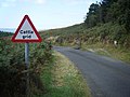 Cattle Grid on road from Loch Ettrick. - geograph.org.uk - 1503798.jpg 640 × 480 ; 78 kio
-
 Church at Closeburn.jpg 4 272 × 2 840 ; 2,95 Mio
-
 Clearing in Auchencairn Forest - geograph.org.uk - 160281.jpg 640 × 480 ; 208 kio
-
 Closeburn - geograph.org.uk - 376699.jpg 640 × 482 ; 97 kio
-
 Closeburn and train on the old G&SWR line from Glasgow to Carlisle via Dumfries.jpg 3 595 × 2 033 ; 1,7 Mio
-
 Closeburn Cemetery - geograph.org.uk - 697761.jpg 640 × 444 ; 87 kio
-
 Closeburn Church - geograph.org.uk - 1407318.jpg 640 × 425 ; 114 kio
-

-
 Closeburn Mains - geograph.org.uk - 1392514.jpg 480 × 640 ; 47 kio
-
 Closeburn old and new churches.JPG 2 288 × 1 712 ; 1,17 Mio
-
 Closeburn Old and New Parish Churches - geograph.org.uk - 377417.jpg 640 × 391 ; 101 kio
-
 Closeburn Primary and Wallace Hall.JPG 2 288 × 1 712 ; 1,3 Mio
-
 Closeburn Primary School - geograph.org.uk - 376662.jpg 640 × 483 ; 106 kio
-
 Closeburn War Memorial - geograph.org.uk - 376709.jpg 640 × 477 ; 96 kio
-
 Closeburnmill - geograph.org.uk - 1392490.jpg 480 × 640 ; 59 kio
-
 Clump of Trees and View from Roadside - geograph.org.uk - 728019.jpg 640 × 480 ; 69 kio
-
 Country road - geograph.org.uk - 376643.jpg 640 × 480 ; 122 kio
-
 Countryside near Stipends - geograph.org.uk - 823276.jpg 640 × 480 ; 40 kio
-
 Cows and Field - geograph.org.uk - 1389950.jpg 480 × 640 ; 55 kio
-
 Dalgarnock Churchyard - geograph.org.uk - 672769.jpg 640 × 480 ; 97 kio
-
 Dalgarnock Churchyard Cross - geograph.org.uk - 672785.jpg 480 × 640 ; 125 kio
-
 Early morning dew on cobwebs on gorse - geograph.org.uk - 598869.jpg 640 × 427 ; 102 kio
-
 Early Morning Mist Across Capel Burn - geograph.org.uk - 600751.jpg 640 × 427 ; 46 kio
-
 Entrance to Auchencairn - geograph.org.uk - 731618.jpg 640 × 480 ; 101 kio
-
 Exposed Roots - geograph.org.uk - 731660.jpg 480 × 640 ; 148 kio
-
 Farm road - geograph.org.uk - 435438.jpg 640 × 480 ; 98 kio
-
 Farm track - geograph.org.uk - 1407312.jpg 640 × 425 ; 124 kio
-
 Farm track above Garroch - geograph.org.uk - 1407311.jpg 640 × 425 ; 111 kio
-
 Fellard - geograph.org.uk - 435456.jpg 640 × 480 ; 98 kio
-
 Fellend Farm - geograph.org.uk - 376631.jpg 640 × 480 ; 99 kio
-
 Field near Gilchristland Cottages - geograph.org.uk - 1503814.jpg 640 × 480 ; 73 kio
-
 Field of horses at Gatelawbridge - geograph.org.uk - 1392472.jpg 480 × 640 ; 52 kio
-
 Fields near Closeburn, Dumfries & Galloway.jpg 4 186 × 6 224 ; 13,89 Mio
-
 Garroch and the fellside above it - geograph.org.uk - 1407313.jpg 640 × 425 ; 107 kio
-
 Garroch Water bridge - geograph.org.uk - 1407242.jpg 640 × 425 ; 103 kio
-
 Garroch Water valley - stony path - geograph.org.uk - 1407249.jpg 640 × 425 ; 120 kio
-
 Ginger Sheep, Mitchellslacks - geograph.org.uk - 601946.jpg 640 × 396 ; 70 kio
-
 Gleds Nest - geograph.org.uk - 598878.jpg 640 × 384 ; 65 kio
-
 Glenbuith streamway - geograph.org.uk - 1407298.jpg 640 × 425 ; 121 kio
-
 Glenbuith streamway meanders - geograph.org.uk - 1407299.jpg 640 × 425 ; 96 kio
-
 Glenbuith valley - geograph.org.uk - 1407293.jpg 640 × 425 ; 94 kio
-
 Grazing field - geograph.org.uk - 435442.jpg 614 × 472 ; 103 kio
-
 Grazing sheep - geograph.org.uk - 376671.jpg 640 × 480 ; 100 kio
-

-
 Hill farmland - geograph.org.uk - 435446.jpg 640 × 480 ; 103 kio
-
 Hill grazing - geograph.org.uk - 376578.jpg 640 × 480 ; 104 kio
-
 Hill grazing - geograph.org.uk - 376636.jpg 640 × 465 ; 88 kio
-
 Hillside above Kenriva Burn - geograph.org.uk - 1407308.jpg 640 × 425 ; 104 kio
-
 Hillside Burn near High Auldgirth - geograph.org.uk - 662031.jpg 480 × 640 ; 121 kio
-
 Hillside East of Capel Burn - geograph.org.uk - 598871.jpg 640 × 384 ; 64 kio
-
 Hillside track near Auldgirth - geograph.org.uk - 662020.jpg 640 × 480 ; 81 kio
-
 Kirkpatrick Farm - geograph.org.uk - 783732.jpg 640 × 395 ; 42 kio
-
 Kirkpatrick Farm, Closeburn, Dumfries and Galloway.jpg 4 014 × 2 071 ; 2,15 Mio
-
 Leaving Auchencairn - geograph.org.uk - 731655.jpg 640 × 480 ; 60 kio
-
 Livestock farmland at Shield Hill - geograph.org.uk - 435432.jpg 640 × 480 ; 93 kio
-
 Loch Ettrick - geograph.org.uk - 160303.jpg 640 × 480 ; 188 kio
-
 Mapa dg cill osbairn.jpg 2 004 × 1 363 ; 599 kio
-
 Motte and Bailey near Dinning, with Sheep - geograph.org.uk - 728006.jpg 640 × 480 ; 58 kio
-
 Near Whitespots - geograph.org.uk - 1324023.jpg 480 × 640 ; 45 kio
-
 New House - geograph.org.uk - 601939.jpg 640 × 427 ; 71 kio
-
 Old and Parish churches, Closeburn, Dumfries and Galloway.jpg 4 608 × 3 456 ; 6,14 Mio
-
 Old church remains at Closeburn - geograph.org.uk - 376682.jpg 640 × 480 ; 101 kio
-
 Old G&SWR from Brownhill railway overbridge, Closeburn, Dumfries & Galloway.jpg 4 608 × 3 456 ; 6,88 Mio
-
 Old G&SWR from Kirkpatrick railway overbridge, Closeburn, Dumfries & Galloway.jpg 4 608 × 3 456 ; 7,11 Mio
-
 Old G&SWR from the Brownhill railway overbridge, Closeburn, Dumfries & Galloway.jpg 4 608 × 3 456 ; 6,83 Mio
-
 One Tree Short of a Copse - geograph.org.uk - 728028.jpg 640 × 480 ; 87 kio
-
 Pasture field - geograph.org.uk - 376656.jpg 609 × 501 ; 113 kio
-
 Pothole Burn Bridge - geograph.org.uk - 731628.jpg 640 × 480 ; 125 kio
-

-
 Rough grazing - geograph.org.uk - 376650.jpg 640 × 480 ; 111 kio
-
 Rough grazing and forestry planting - geograph.org.uk - 376572.jpg 640 × 449 ; 102 kio
-
 Ruined cottage - geograph.org.uk - 211186.jpg 425 × 640 ; 148 kio
-
 Shawsmuir Farm - geograph.org.uk - 376721.jpg 640 × 480 ; 99 kio
-
 Sheepfolds near The Law - geograph.org.uk - 380439.jpg 633 × 449 ; 123 kio
-
 Soft Verge Markers - geograph.org.uk - 731648.jpg 640 × 480 ; 138 kio
-

-
 Tarmac driveway up to Blackwood - geograph.org.uk - 409433.jpg 640 × 480 ; 122 kio
-
 Templand - geograph.org.uk - 453182.jpg 640 × 427 ; 103 kio
-
 The 1741 old kirk gable end, Closeburn, Dumfries & Galloway.jpg 4 026 × 3 039 ; 5,01 Mio
-
 The A76 - geograph.org.uk - 670044.jpg 640 × 381 ; 62 kio
-
 The Garroch Water - geograph.org.uk - 380478.jpg 640 × 480 ; 107 kio
-
 The lane just off the A76 road at Stepends - geograph.org.uk - 409422.jpg 640 × 480 ; 128 kio
-
 The railway bridge at Cample - geograph.org.uk - 398911.jpg 617 × 474 ; 103 kio
-
 The road to Park - geograph.org.uk - 435441.jpg 640 × 480 ; 117 kio
-
 The trig point on Linnburn Hill - geograph.org.uk - 435452.jpg 640 × 480 ; 100 kio
-
 Townfoot Farm sign - geograph.org.uk - 377420.jpg 640 × 629 ; 105 kio
-
 Track up to Berscar - geograph.org.uk - 409329.jpg 640 × 480 ; 104 kio
-
 Trees and Mounds - geograph.org.uk - 728031.jpg 640 × 480 ; 85 kio
-
 Trundling and Thief Knowes, Closeburn, Dumfries and Galloway.jpg 4 325 × 2 020 ; 1,64 Mio
-
 Trundling Knowe at Dawn - geograph.org.uk - 979330.jpg 480 × 640 ; 34 kio
-
 Unpaved road south of Dressertland - geograph.org.uk - 1392508.jpg 480 × 640 ; 66 kio
-
 Upland grazing - geograph.org.uk - 376589.jpg 640 × 480 ; 100 kio
-
 View From the Entrance to Upper Rig - geograph.org.uk - 731611.jpg 640 × 480 ; 76 kio
-
 View of Closeburnmill - geograph.org.uk - 728076.jpg 640 × 480 ; 103 kio
-
 View of Upper Rig - geograph.org.uk - 731630.jpg 640 × 480 ; 86 kio
-
 View to Locherben Farm - geograph.org.uk - 1407314.jpg 640 × 425 ; 91 kio
-
 Wallace Academy, Closeburn, Dumfries and Galloway, Scotland. View from the South.jpg 4 588 × 3 430 ; 4,65 Mio
-
 Ahh the hillocks. Not far from Gracefield. - geograph.org.uk - 211033.jpg 640 × 425 ; 96 kio
-
 Another part of the ruined cottage. - geograph.org.uk - 211195.jpg 640 × 425 ; 167 kio
-
 Cottages at Campleslacks - geograph.org.uk - 219629.jpg 640 × 480 ; 104 kio
-
 Fence Repairs - geograph.org.uk - 728086.jpg 640 × 480 ; 88 kio
-

-
 House Building in Croalchapel - geograph.org.uk - 731671.jpg 640 × 480 ; 78 kio
-
 New House - geograph.org.uk - 601937.jpg 640 × 427 ; 80 kio
-
 New House. - geograph.org.uk - 9132.jpg 640 × 480 ; 74 kio
-
 Pasture field - geograph.org.uk - 376693.jpg 640 × 456 ; 99 kio
-
 Roadside Quarry - geograph.org.uk - 160307.jpg 640 × 480 ; 163 kio
-
 Sheep Grazing on the Slopes of Capel Burn - geograph.org.uk - 600755.jpg 640 × 427 ; 83 kio
-
 The Law - geograph.org.uk - 601949.jpg 640 × 427 ; 68 kio
-
 The road to Shawsholm Farm - geograph.org.uk - 376716.jpg 640 × 480 ; 113 kio
-
 Track above the Capel Burn - geograph.org.uk - 9130.jpg 640 × 480 ; 81 kio
-
 Track in Ettrick Hill Forest - geograph.org.uk - 160306.jpg 640 × 480 ; 176 kio
-
 Track Near Great Hill - geograph.org.uk - 160302.jpg 640 × 480 ; 183 kio
-
 Track on Great Hill - geograph.org.uk - 160301.jpg 640 × 480 ; 175 kio


