Category:Coehoornsingel 117 (Groningen)
Jump to navigation
Jump to search
| Object location | | View all coordinates using: OpenStreetMap |
|---|
 | |||||
| Upload media | |||||
| Instance of | |||||
|---|---|---|---|---|---|
| Location | Groningen, Netherlands | ||||
| Located on street | |||||
| Heritage designation |
| ||||
 | |||||
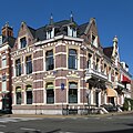
Nederlands: Coehoornsingel 117 (hoek Stationsstraat), Groningen, rm 485501
|
This is a category about rijksmonument number 485501
|
| Address |
|
Media in category "Coehoornsingel 117 (Groningen)"
The following 3 files are in this category, out of 3 total.
-
 20100626 Coehoornsingel 115 (Hofsburg-Hof's Burg) Groningen NL.jpg 2,100 × 2,800; 3.96 MB
-
 20100626 Coehoornsingel 117 Groningen NL.jpg 2,000 × 2,000; 2.87 MB
-
 Overzicht Stationsstraat - Groningen - 20092367 - RCE.jpg 1,200 × 1,194; 299 KB
_Groningen_NL.jpg)
