Category:Condover
Aller à la navigation
Aller à la recherche
village britannique  | |||||
| Téléverser des médias | |||||
| Nature de l’élément | |||||
|---|---|---|---|---|---|
| Lieu | Shropshire, Midlands de l'Ouest, Angleterre | ||||
| Réputé identique à | Condover (page en doublon, paroisse civile) | ||||
| site officiel | |||||
 | |||||
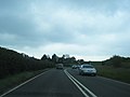
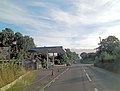
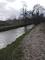
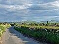
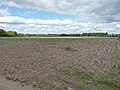
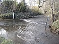
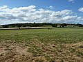
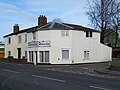
English: Condover is a village and civil parish in Shropshire, England. It lies 4.7 miles (7.8 kilometres) south of the county town of Shrewsbury, and just east of the A49. The Cound Brook flows through the village on its way from the Stretton Hills to a confluence with the River Severn. Condover is near to the villages of Dorrington and Bayston Hill, and is the nearest notable settlement to the spot that is the centre point of the geographic county of Shropshire. The centre of the county lies just to the north in a field. The population of the Condover and Cound ward was recorded as 2,140 in the last census, of which approximately 900 live in Condover itself.
Sous-catégories
Cette catégorie comprend 5 sous-catégories, dont les 5 ci-dessous.
B
- Condover Bridge (3 F)
C
- Condover Hall (5 F)
- Condover railway station (2 F)
Média dans la catégorie « Condover »
Cette catégorie comprend 330 fichiers, dont les 200 ci-dessous.
(page précédente) (page suivante)-
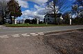
 30mph limit approaching Condover - geograph.org.uk - 5539117.jpg 1 469 × 1 102 ; 650 kio
-
 7 Church Street, Condover.jpg 2 448 × 1 836 ; 1,33 Mio
-
 A bridleway and farm track near Castle Place - geograph.org.uk - 3513881.jpg 979 × 734 ; 480 kio
-
 A footpath across a hayfield - geograph.org.uk - 3513885.jpg 1 142 × 857 ; 425 kio
-
 A footpath back to Stapleton - geograph.org.uk - 3512498.jpg 1 110 × 832 ; 405 kio
-
 A footpath heads for Moat Farm - geograph.org.uk - 3512532.jpg 857 × 1 142 ; 405 kio
-
 A small stream between Shadymoor and Stapleton - geograph.org.uk - 3512504.jpg 734 × 979 ; 465 kio
-
 A Stile - geograph.org.uk - 3924481.jpg 640 × 480 ; 76 kio
-
 A track and an oak tree north of Shadymoor - geograph.org.uk - 3512514.jpg 1 142 × 857 ; 361 kio
-
 A49 at Chatbrook - geograph.org.uk - 3545393.jpg 640 × 480 ; 33 kio
-
 A49 at Front Lodge - geograph.org.uk - 3545367.jpg 640 × 480 ; 30 kio
-
 A49 at Stapleton crossroads - geograph.org.uk - 3546171.jpg 631 × 470 ; 166 kio
-
 A49 at Wayford Bridge - geograph.org.uk - 2958315.jpg 640 × 480 ; 49 kio
-
 A49 climbing to cross the railway - geograph.org.uk - 3545364.jpg 640 × 480 ; 27 kio
-
 A49 descends Hunger Hill - geograph.org.uk - 3772583.jpg 3 648 × 2 736 ; 1,51 Mio
-
 A49 east of Little Lyth - geograph.org.uk - 2958337.jpg 640 × 481 ; 35 kio
-
 A49 east of Micklewood Farm - geograph.org.uk - 3773161.jpg 3 648 × 2 736 ; 1,32 Mio
-
 A49 enters Stapleton - geograph.org.uk - 3772608.jpg 3 399 × 2 492 ; 1,31 Mio
-
 A49 junction with Grange Lane - geograph.org.uk - 3772591.jpg 3 096 × 2 408 ; 881 kio
-
 A49 junction with un-named lane to Stapleton - geograph.org.uk - 3773138.jpg 3 648 × 2 736 ; 1,91 Mio
-
 A49 looking north - geograph.org.uk - 2958326.jpg 640 × 480 ; 32 kio
-
 A49 passes Gulf Filling Station - geograph.org.uk - 3773013.jpg 3 359 × 2 542 ; 1,52 Mio
-
 A49 vista - geograph.org.uk - 3545399.jpg 640 × 480 ; 25 kio
-
 Access road to Norton Farm and the gravel pit - geograph.org.uk - 5591442.jpg 1 600 × 1 200 ; 802 kio
-
 Allfield farmhouse - geograph.org.uk - 5540698.jpg 2 448 × 1 836 ; 1,71 Mio
-
 At the road junction to Wheathall and Frodesley - geograph.org.uk - 5537485.jpg 1 469 × 1 102 ; 555 kio
-
 At the turn to Boreton and Berrington - geograph.org.uk - 5540711.jpg 1 469 × 1 102 ; 604 kio
-
 Baled hay in a field - geograph.org.uk - 3513878.jpg 1 142 × 857 ; 379 kio
-
 Baled straw north of Norton Farm - geograph.org.uk - 6088561.jpg 1 469 × 1 102 ; 518 kio
-
 Barns at Allfield farm - geograph.org.uk - 5540701.jpg 1 142 × 857 ; 381 kio
-
 Barns at Ryton Farm - geograph.org.uk - 5543328.jpg 1 632 × 1 224 ; 792 kio
-
 Beets at Norton Farm - geograph.org.uk - 6088559.jpg 1 469 × 1 102 ; 446 kio
-
 Berriewood - geograph.org.uk - 3864019.jpg 640 × 480 ; 327 kio
-
 Berriewood Solar Farm - geograph.org.uk - 5543306.jpg 1 632 × 1 224 ; 647 kio
-
 Berriewood Stud Farm - geograph.org.uk - 5543302.jpg 1 306 × 979 ; 529 kio
-
 Between Ryton and Longnor - geograph.org.uk - 5858749.jpg 1 024 × 685 ; 325 kio
-
 Brick barn at Westley - geograph.org.uk - 3469505.jpg 1 142 × 857 ; 362 kio
-
 Bridge Inn - Dorrington - geograph.org.uk - 4862137.jpg 3 574 × 2 433 ; 1,16 Mio
-
 Bridleway ford near Upper Shadymoor - geograph.org.uk - 1879673.jpg 640 × 480 ; 213 kio
-
 Bridleway in Little Shadymoor Coppice - geograph.org.uk - 1879706.jpg 640 × 480 ; 200 kio
-
 Building near Allfield - geograph.org.uk - 4896496.jpg 1 200 × 769 ; 290 kio
-
 Building site and its hoarding, Dorrington - geograph.org.uk - 5591568.jpg 1 600 × 1 200 ; 703 kio
-
 Buildings at Westley Farm - geograph.org.uk - 4896450.jpg 1 200 × 817 ; 334 kio
-
 Bus shelter, Condover - geograph.org.uk - 3865003.jpg 640 × 480 ; 318 kio
-
 Business signs, Lower Netley - geograph.org.uk - 5567496.jpg 1 024 × 683 ; 278 kio
-
 Canadian airmen at Condover 1945.jpg 175 × 130 ; 5 kio
-
 Car Wash near Stapleton - geograph.org.uk - 4877300.jpg 2 674 × 2 142 ; 947 kio
-
 Castle Motte at Stapleton - geograph.org.uk - 3512480.jpg 979 × 734 ; 392 kio
-
 Castle Place farm buildings - geograph.org.uk - 3513883.jpg 1 142 × 857 ; 416 kio
-
 Chatford House and farm buildings - geograph.org.uk - 3520132.jpg 1 142 × 857 ; 388 kio
-
 Church Bridge near Dorrington - geograph.org.uk - 5591534.jpg 1 600 × 1 332 ; 757 kio
-
 Church Road, Dorrington - geograph.org.uk - 5223095.jpg 1 024 × 683 ; 315 kio
-
 Church Street, Condover - geograph.org.uk - 5591466.jpg 1 600 × 1 067 ; 722 kio
-
 Church Stretton - Shrewsbury railway (1) - geograph.org.uk - 2487011.jpg 640 × 480 ; 233 kio
-
 Churchyard, Dorrington - geograph.org.uk - 5062275.jpg 1 024 × 683 ; 415 kio
-
 Climbing Hunger Hill, northbound A49 - geograph.org.uk - 3545394.jpg 640 × 480 ; 33 kio
-
 Condover - direction sign - geograph.org.uk - 6088573.jpg 979 × 1 306 ; 722 kio
-
 Condover C of E Primary - geograph.org.uk - 5540684.jpg 1 469 × 1 102 ; 442 kio
-
 Condover C.E. Primary School - geograph.org.uk - 3924473.jpg 640 × 427 ; 480 kio
-
 Condover Ford - geograph.org.uk - 4018982.jpg 3 872 × 2 592 ; 4,82 Mio
-
 Condover geograph-2527125-by-Ben-Brooksbank.jpg 1 991 × 1 447 ; 718 kio
-
 Condover Post Office - geograph.org.uk - 5540576.jpg 2 448 × 1 836 ; 1,58 Mio
-
 Condover Primary School - geograph.org.uk - 5591448.jpg 1 600 × 1 199 ; 683 kio
-
 Condover railway station - geograph.org.uk - 4096436.jpg 1 718 × 1 144 ; 1,25 Mio
-
 Condover Station Road overbridge - geograph.org.uk - 2507290.jpg 640 × 441 ; 84 kio
-
 Condover Station was once here - geograph.org.uk - 2507274.jpg 640 × 425 ; 72 kio
-
 Condover village sports ground - geograph.org.uk - 6088566.jpg 1 629 × 1 054 ; 484 kio
-
 Condover village sports ground - geograph.org.uk - 6088568.jpg 1 632 × 1 224 ; 682 kio
-
 Corfield's Coppice - geograph.org.uk - 3512527.jpg 1 306 × 979 ; 381 kio
-
 Cound Brook - geograph.org.uk - 3924443.jpg 480 × 640 ; 69 kio
-
 Cound Brook ford, Condover - geograph.org.uk - 5540706.jpg 1 469 × 1 102 ; 826 kio
-
 Cound Brook near Condover - geograph.org.uk - 2147054.jpg 640 × 480 ; 315 kio
-
 Cound Brook, Condover. - geograph.org.uk - 716367.jpg 640 × 480 ; 132 kio
-
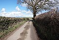
 Country lane near Condover - geograph.org.uk - 4846819.jpg 1 600 × 1 200 ; 1,11 Mio
-
 Country lane to Great Ryton - geograph.org.uk - 2820972.jpg 1 024 × 659 ; 207 kio
-
 Country road near Condover (1) - geograph.org.uk - 6005735.jpg 640 × 476 ; 183 kio
-
 Country road near Condover (2) - geograph.org.uk - 6005742.jpg 640 × 483 ; 177 kio
-
 Country road near Great Ryton - geograph.org.uk - 6005752.jpg 640 × 480 ; 133 kio
-
 Country road, Condover - geograph.org.uk - 2147012.jpg 529 × 640 ; 202 kio
-
 Crossroads north of Condover - geograph.org.uk - 5540688.jpg 1 469 × 1 102 ; 608 kio
-
 Crossroads of lanes - geograph.org.uk - 3520126.jpg 857 × 1 142 ; 354 kio
-
 Deer farm at Exfords Green - geograph.org.uk - 628767.jpg 640 × 480 ; 80 kio
-
 Derelict control tower at former RAF Condover - geograph.org.uk - 5813486.jpg 4 032 × 3 024 ; 3,21 Mio
-
 Dorrington School - geograph.org.uk - 5062279.jpg 1 024 × 683 ; 296 kio
-
 Dorrington to Stapleton Road - geograph.org.uk - 5876585.jpg 1 024 × 683 ; 321 kio
-
 Dorrington Village Stores and Post Office - geograph.org.uk - 5537538.jpg 640 × 480 ; 53 kio
-
 Driveway into farm buildings - geograph.org.uk - 5307431.jpg 640 × 480 ; 54 kio
-
 Driveway to Lower Netley Farm - geograph.org.uk - 2119690.jpg 640 × 480 ; 277 kio
-
 Driveway to Stone House Farm, 2016 - geograph.org.uk - 4848519.jpg 1 600 × 901 ; 604 kio
-
 Edge of the Cound Brook flood plain - geograph.org.uk - 4846831.jpg 1 600 × 901 ; 729 kio
-
 Farm buildings at Allfield - geograph.org.uk - 4846826.jpg 1 600 × 901 ; 800 kio
-
 Farm buildings at Allfield - geograph.org.uk - 4896502.jpg 1 200 × 828 ; 303 kio
-
 Farm buildings at Westley - geograph.org.uk - 2119694.jpg 615 × 449 ; 103 kio
-
 Farm machinery ^ silage near Orchard Farm - geograph.org.uk - 5536357.jpg 1 306 × 979 ; 675 kio
-
 Farm track near Orchard Farm - geograph.org.uk - 5536354.jpg 1 306 × 979 ; 707 kio
-
 Farm yard and sheds at Ryton - geograph.org.uk - 6212817.jpg 640 × 480 ; 43 kio
-
 Farmland near Bayston Hill - geograph.org.uk - 6006091.jpg 640 × 480 ; 139 kio
-
 Farmland near Condover (2) - geograph.org.uk - 6005740.jpg 640 × 475 ; 191 kio
-
 Farmland near Condover - geograph.org.uk - 2138374.jpg 640 × 480 ; 218 kio
-
 Farmland south of Bayston Hill - geograph.org.uk - 6088546.jpg 1 469 × 1 102 ; 584 kio
-
 Field and Upper Wood - geograph.org.uk - 5223086.jpg 1 024 × 683 ; 339 kio
-
 Field and woodland - geograph.org.uk - 2119673.jpg 640 × 480 ; 327 kio
-
 Field of carrots - geograph.org.uk - 628800.jpg 640 × 359 ; 89 kio
-
 Field of stubble north of Grove Farm - geograph.org.uk - 5539113.jpg 1 306 × 979 ; 533 kio
-
 Field of stubble, Park Stile - geograph.org.uk - 5540726.jpg 1 306 × 979 ; 535 kio
-
 Field, Netley - geograph.org.uk - 5223093.jpg 1 024 × 683 ; 293 kio
-
 Filling station on A49 in Stapleton - geograph.org.uk - 2125539.jpg 555 × 393 ; 151 kio
-
 First of three signs at the view point on Lyth Hill - geograph.org.uk - 2068646.jpg 2 848 × 2 136 ; 1,55 Mio
-
 Flooded gravel pit workings in Stapleton - geograph.org.uk - 1881060.jpg 845 × 634 ; 169 kio
-
 Footbridge over a stream - geograph.org.uk - 1879731.jpg 480 × 640 ; 217 kio
-
 Footpath at Westley Farm - geograph.org.uk - 4896454.jpg 1 200 × 799 ; 431 kio
-
 Footpath down to Westley farm - geograph.org.uk - 3469498.jpg 1 142 × 857 ; 423 kio
-
 Footpath emerging onto lane near Dorrington Grove - geograph.org.uk - 5529458.jpg 1 306 × 979 ; 642 kio
-
 Footpath to Dorrington Grove - geograph.org.uk - 5529432.jpg 1 469 × 1 102 ; 608 kio
-
 Footpath towards Stapleton - geograph.org.uk - 3520138.jpg 734 × 979 ; 299 kio
-
 Ford across the brook - geograph.org.uk - 3518463.jpg 1 142 × 857 ; 497 kio
-

-
 Ford at Stapleton - geograph.org.uk - 4715475.jpg 1 086 × 724 ; 522 kio
-
 Ford near Condover - geograph.org.uk - 2147045.jpg 640 × 480 ; 309 kio
-
 Ford, Cound Brook - geograph.org.uk - 3924487.jpg 640 × 480 ; 100 kio
-
 Fork in the lane - geograph.org.uk - 5279539.jpg 640 × 480 ; 38 kio
-
 Free range chickens at Moat Farm - geograph.org.uk - 3513870.jpg 1 142 × 857 ; 480 kio
-

-
 Friesians grazing at Hunger Hill - geograph.org.uk - 4569414.jpg 1 142 × 857 ; 435 kio
-
 Frosty arable field - geograph.org.uk - 4846800.jpg 1 600 × 901 ; 652 kio
-
 Georgian postbox at Wheathall - geograph.org.uk - 5543311.jpg 1 224 × 1 632 ; 942 kio
-
 Grassland, Chatford - geograph.org.uk - 910505.jpg 640 × 480 ; 50 kio
-
 Grazing and trees near Stapleton - geograph.org.uk - 6112560.jpg 640 × 420 ; 86 kio
-
 Grazing near Dorrington - geograph.org.uk - 6112556.jpg 800 × 541 ; 87 kio
-
 Grove Farm south of Condover - geograph.org.uk - 5591473.jpg 1 600 × 1 066 ; 567 kio
-
 Grove Farmhouse - geograph.org.uk - 5537502.jpg 2 448 × 1 836 ; 1,92 Mio
-
 Grove Farmhouse, Dorrington - geograph.org.uk - 5537142.jpg 1 469 × 1 102 ; 514 kio
-
 Hand car wash sign on A49 in Stapleton - geograph.org.uk - 4467732.jpg 1 600 × 1 600 ; 1,34 Mio
-
 House north of Condover - geograph.org.uk - 4896487.jpg 1 200 × 782 ; 445 kio
-
 Hunger Hill summit, A49 - geograph.org.uk - 3545396.jpg 640 × 480 ; 21 kio
-
 Jubilee Farm, Dorrington - geograph.org.uk - 5223097.jpg 1 024 × 683 ; 314 kio
-
 Junction of bridleways near Upper Shadymoor - geograph.org.uk - 1879687.jpg 768 × 576 ; 192 kio
-
 Kissing gate, Home Farm - geograph.org.uk - 3863933.jpg 640 × 480 ; 257 kio
-
 Lane junction - geograph.org.uk - 5307419.jpg 640 × 480 ; 94 kio
-
 Lane junction between Stapleton and Wilderley - geograph.org.uk - 3513858.jpg 1 142 × 857 ; 422 kio
-
 Lane near Moat Farm - geograph.org.uk - 2119678.jpg 640 × 480 ; 315 kio
-
 Lane north of Berriewood Stud - geograph.org.uk - 5540735.jpg 1 306 × 979 ; 589 kio
-
 Lane passing Condover Industrial Estate - geograph.org.uk - 3864037.jpg 640 × 480 ; 321 kio
-
 Lane towards Cantlop - geograph.org.uk - 5540723.jpg 1 102 × 1 469 ; 591 kio
-
 Lane towards Condover - geograph.org.uk - 5540729.jpg 1 306 × 979 ; 576 kio
-
 Lane towards Ryton Grove - geograph.org.uk - 5543309.jpg 1 306 × 979 ; 629 kio
-
 Lane, Condover Green - geograph.org.uk - 3863926.jpg 640 × 480 ; 322 kio
-
 Lane, Little Ryton - geograph.org.uk - 3864058.jpg 640 × 480 ; 287 kio
-
 Listed barn at Hill Top farm - geograph.org.uk - 5537207.jpg 2 448 × 1 836 ; 1,38 Mio
-
 Looking north towards Bayston Hill - geograph.org.uk - 6088547.jpg 1 469 × 1 102 ; 492 kio
-
 Lower Netley Farm house - geograph.org.uk - 1878286.jpg 691 × 518 ; 189 kio
-
 Many sheep - geograph.org.uk - 5529462.jpg 1 306 × 979 ; 487 kio
-

-
 Milepost north of Ryton - geograph.org.uk - 5537480.jpg 1 749 × 2 962 ; 1,67 Mio
-
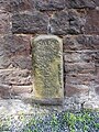 Milestone, Condover.jpg 1 102 × 1 469 ; 909 kio
-
 Minor road north of Condover - geograph.org.uk - 4896467.jpg 1 200 × 822 ; 480 kio
-
 Moat Farm barns - geograph.org.uk - 3513873.jpg 1 142 × 857 ; 373 kio
-
 More or less disused farm track - geograph.org.uk - 5529426.jpg 979 × 1 306 ; 726 kio
-
 More outbuildings at Grove Farm - geograph.org.uk - 858970.jpg 640 × 480 ; 318 kio
-
 Muddy lane, Wheathall - geograph.org.uk - 3864046.jpg 640 × 480 ; 309 kio
-
 Narrow lane SW of Allfield Farm - geograph.org.uk - 5540692.jpg 1 306 × 979 ; 522 kio
-
 Narrow lane towards Allfield Farm - geograph.org.uk - 5540690.jpg 857 × 1 142 ; 369 kio
-
 Northbound on the A49 - geograph.org.uk - 3545400.jpg 640 × 480 ; 21 kio
-
 Northwards on the railway line - geograph.org.uk - 5537107.jpg 1 102 × 1 469 ; 631 kio
-
 Norton farm buildings - geograph.org.uk - 6088562.jpg 1 469 × 1 102 ; 610 kio
-
 Nuisance on School Premises is an Offence - geograph.org.uk - 3865028.jpg 640 × 480 ; 276 kio
-
 Oak overhanging the road at Dunstone - geograph.org.uk - 5591520.jpg 1 600 × 1 280 ; 856 kio
-
 Off the lead in a hayfield - geograph.org.uk - 3513875.jpg 1 142 × 857 ; 388 kio
-
 Off to market - May 2018 - geograph.org.uk - 5793403.jpg 1 250 × 619 ; 1,1 Mio
-
 Oilseed rape, Condover Park - geograph.org.uk - 3864014.jpg 640 × 480 ; 279 kio
-
 Oilseed rape, Netley - geograph.org.uk - 5223089.jpg 1 024 × 683 ; 301 kio
-
 Old and new on the railway bridge - geograph.org.uk - 5537119.jpg 1 469 × 1 102 ; 657 kio
-
 Old barns beside the track - geograph.org.uk - 6212983.jpg 640 × 480 ; 57 kio
-

-

-
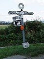
 Old Direction Sign - Signpost in Condover - geograph.org.uk - 6035467.jpg 600 × 800 ; 113 kio
-

-

-
-

-
-
 Old water conduit head, Condover - geograph.org.uk - 5540518.jpg 1 805 × 2 369 ; 2,01 Mio
-
 On a field edge path - geograph.org.uk - 6212987.jpg 640 × 480 ; 50 kio
-
 On a footpath south of Little Ryton - geograph.org.uk - 5529451.jpg 1 469 × 1 102 ; 660 kio
-
 On the lane NE of Condover - geograph.org.uk - 5540703.jpg 1 306 × 979 ; 431 kio
-
 On the lane south of Rowbrook Farm - geograph.org.uk - 5543307.jpg 979 × 1 306 ; 525 kio
-
 Ordnance Survey Cut Mark - geograph.org.uk - 5143118.jpg 640 × 630 ; 146 kio
-
 Ordnance Survey Cut Mark - geograph.org.uk - 5143119.jpg 452 × 640 ; 97 kio
-
 OS benchmark - Condover Park entranceway - geograph.org.uk - 5540741.jpg 979 × 1 306 ; 788 kio
-
 OS benchmark - Condover, buttress of school - geograph.org.uk - 5540686.jpg 814 × 1 088 ; 444 kio
-
 OS benchmark - Condover, roadside wall - geograph.org.uk - 5540158.jpg 979 × 1 306 ; 821 kio
-
 OS benchmark - Condover, St Mary ^ St Andrew Church - geograph.org.uk - 5540544.jpg 857 × 1 142 ; 580 kio
-
 OS benchmark - Dorrington, railway bridge - geograph.org.uk - 5537160.jpg 1 102 × 1 469 ; 915 kio
-
 OS benchmark - Great Ryton, wall north of road junction - geograph.org.uk - 5537194.jpg 857 × 1 142 ; 659 kio
-
 OS benchmark - Wheathall, wall by postbox - geograph.org.uk - 5543318.jpg 979 × 1 306 ; 756 kio
-
 OS flush bracket - Hunger Hill - geograph.org.uk - 4561116.jpg 857 × 1 142 ; 570 kio
-
 OS flush bracket - Wayford Bridge - geograph.org.uk - 4569441.jpg 857 × 1 142 ; 511 kio
-
 Parking for the horse trials at Berriewood Farm - geograph.org.uk - 5813484.jpg 4 032 × 3 024 ; 3,37 Mio
-

-
 Path beside an Oak tree - geograph.org.uk - 6212992.jpg 640 × 480 ; 78 kio


_-_geograph.org.uk_-_2487011.jpg)


_-_geograph.org.uk_-_6005735.jpg)
_-_geograph.org.uk_-_6005742.jpg)


_-_geograph.org.uk_-_6005740.jpg)


_(14577532487).jpg)


