Category:Cranger Kirche
Jump to navigation
Jump to search
| Object location | | View all coordinates using: OpenStreetMap |
|---|
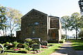
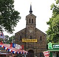
church building in Wanne, Germany  | |||||
| Upload media | |||||
| Instance of | |||||
|---|---|---|---|---|---|
| Named after | |||||
| Location |
| ||||
| Street address |
| ||||
| Architectural style | |||||
| Heritage designation | |||||
 | |||||
Media in category "Cranger Kirche"
The following 19 files are in this category, out of 19 total.
-
 Alte Laurentiuskapelle in Crange - panoramio.jpg 2,400 × 1,348; 1.03 MB
-
 Church of Crange Altar Bible open.jpg 3,264 × 2,200; 1.98 MB
-
 Church of Crange Bible.jpg 3,211 × 2,200; 1.34 MB
-
 Church of Crange interior view.jpg 3,136 × 2,344; 1.6 MB
-
 Herne - An der Cranger Kirche - Cranger Kirche 01 ies.jpg 3,888 × 2,592; 3.46 MB
-
 Herne - An der Cranger Kirche - Cranger Kirche 02 ies.jpg 3,888 × 2,592; 3.58 MB
-
 Herne - An der Cranger Kirche - Cranger Kirche 03 ies.jpg 2,592 × 3,888; 1.96 MB
-
 Herne - An der Cranger Kirche - Cranger Kirche 04 ies.jpg 2,592 × 3,888; 1.45 MB
-
 Herne - An der Cranger Kirche - Cranger Kirche 05 ies.jpg 3,888 × 2,592; 2.82 MB
-
 Herne - An der Cranger Kirche - Cranger Kirche 06 ies.jpg 3,888 × 2,592; 3 MB
-
 Herne - An der Cranger Kirche - Cranger Kirche 07 ies.jpg 2,592 × 3,888; 1.94 MB
-
 Herne - An der Cranger Kirche - Cranger Kirche 08 ies.jpg 3,888 × 2,592; 1.98 MB
-
 Herne - An der Cranger Kirche - Cranger Kirche 09 ies.jpg 3,888 × 2,592; 2.14 MB
-
 Herne - An der Cranger Kirche - Cranger Kirche 10 ies.jpg 3,888 × 2,592; 1.7 MB
-
 Herne - Cranger Kirmes 2012 043 ies (cropped).jpg 3,614 × 3,497; 4.89 MB
-
 Herne - Cranger Kirmes 2012 043 ies.jpg 3,744 × 5,616; 7.51 MB
-
 Herne - Cranger Kirmes 2012 044 ies.jpg 3,744 × 5,616; 7.04 MB
-
 Herne Baudenkmal 32 Cranger Kirche Herne-9948.jpg 3,444 × 2,361; 2.44 MB
-
 Herne church of Crange.jpg 2,366 × 3,154; 3.04 MB


.jpg)


