Category:Custer County, Idaho
Zur Navigation springen
Zur Suche springen
Counties of Idaho: Ada · Adams · Bannock · Bear Lake · Benewah · Bingham · Blaine · Boise · Bonner · Bonneville · Boundary · Butte · Camas · Canyon · Caribou · Cassia · Clark · Clearwater · Custer · Elmore · Franklin · Fremont · Gem · Gooding · Idaho · Jefferson · Jerome · Kootenai · Latah · Lemhi · Lewis · Lincoln · Madison · Minidoka · Nez Perce · Oneida · Owyhee · Payette · Power · Shoshone · Teton · Twin Falls · Valley · Washington
County im US-Bundesstaat Idaho   | |||||
| Medium hochladen | |||||
| Ist ein(e) | |||||
|---|---|---|---|---|---|
| Benannt nach | |||||
| Ort | Idaho | ||||
| Hauptstadt | |||||
| Datum der Gründung, Erstellung, Entstehung, Erbauung |
| ||||
| Einwohnerzahl |
| ||||
| Fläche |
| ||||
| Verschieden von | |||||
| offizielle Website | |||||
 | |||||
English: Media related to Custer County, Idaho, a county in central Idaho, United States.
Unterkategorien
Es werden 10 von insgesamt 10 Unterkategorien in dieser Kategorie angezeigt:
In Klammern die Anzahl der enthaltenen Kategorien (K), Seiten (S), Dateien (D)
Medien in der Kategorie „Custer County, Idaho“
Folgende 187 Dateien sind in dieser Kategorie, von 187 insgesamt.
-
 -IDAHO-B-0109- Salmon River - Clayton (6534801775).jpg 1.613 × 1.030; 238 KB
-
 100 2517 Jerry Peak (21613283680).jpg 4.000 × 2.196; 5,72 MB
-
 100 2522 BLM CFO Jerry Peak (21614416089).jpg 4.000 × 3.000; 4,87 MB
-
 2011 Road Odyssey Pictures of 2011 (5933442457).jpg 480 × 640; 92 KB
-
 500px photo (27037981).jpeg 2.048 × 1.394; 935 KB
-
 Above Jimmy Smith Lake.JPG 1.600 × 1.200; 449 KB
-
 Above Sunbeam Dam.jpg 1.600 × 1.200; 271 KB
-
 Alpine Lake and Alpine Peak.jpg 2.816 × 2.112; 3,51 MB
-
 Alpine Lake in Sawtooth Wilderness.jpg 3.648 × 2.736; 3,63 MB
-
 Alpine Way Trial south of Marshall Lake.JPG 2.816 × 2.112; 3,29 MB
-
 Arrowhead Lake in Pioneer Mountains.JPG 2.736 × 3.648; 6,21 MB
-
 Balsamroot in SNRA.JPG 2.048 × 1.536; 2,88 MB
-
 Bayhorse Creek (23315397169).jpg 4.432 × 2.188; 6,66 MB
-
 Bayhorse Creek (23387687170).jpg 4.871 × 2.316; 7,05 MB
-
 Bayhorse Creek, BLM Challis Field Office (23055231024).jpg 2.464 × 1.632; 1,04 MB
-
 Bayhorse Creek, BLM Challis Field Office (23683326595).jpg 906 × 600; 571 KB
-
 Bayhorse Creek, BLM Challis Field Office (23683326825).jpg 1.242 × 600; 765 KB
-
 Behind Stanley Lake 1.JPG 1.600 × 1.200; 430 KB
-
 Behind Stanley Lake 2.JPG 1.600 × 1.200; 438 KB
-
 Behind Stanley Lake 3.JPG 1.600 × 1.200; 393 KB
-
 Bench Lake puddle and Mount Heyburn.jpg 1.500 × 1.072; 2,11 MB
-
 Bench Lake Sunrise.jpg 1.000 × 669; 423 KB
-
 Big Lake Creek.JPG 1.600 × 1.200; 453 KB
-
 Bighorn sheep near Jim McClure Jerry Peak Wilderness (23261261274).jpg 4.000 × 2.256; 2,64 MB
-
 BLM Idaho State Director Tim Murphy in Jerry Peak Wilderness (23806969991).jpg 5.184 × 3.456; 6,74 MB
-
 Bonanza Ghost town 17-9-08 - panoramio.jpg 850 × 638; 143 KB
-
 BrunoCreekTailingsImpoundment2009.jpg 1.024 × 680; 284 KB
-
 Buckwheat SNRA.JPG 2.048 × 1.536; 3,37 MB
-
 Bull Trout.JPG 1.600 × 1.200; 1,23 MB
-
 Cabin with Sawtooths backdrop.jpg 1.000 × 670; 626 KB
-
 Camping in Stanley ID.jpg 1.600 × 1.200; 160 KB
-
 Chinook Salmon in SNRA.JPG 1.600 × 1.200; 358 KB
-
 Clouds over Sawtooths.jpg 1.600 × 1.200; 92 KB
-
 Columbia spotted frog eggs 1.JPG 1.600 × 1.200; 409 KB
-
 Columbia spotted frog eggs 2.JPG 1.600 × 1.200; 430 KB
-
 Crooked Creek 1.JPG 1.600 × 1.200; 387 KB
-
 Crooked Creek 2.JPG 1.600 × 1.200; 370 KB
-
 Custer County, ID, USA - panoramio (2).jpg 1.936 × 2.592; 2,05 MB
-
 Custer Motorway along Garden Creek (23600909191).jpg 2.544 × 1.382; 2,41 MB
-
 Cutthroat Trout.JPG 2.816 × 2.112; 4,07 MB
-
 Decker Peak.jpg 1.646 × 1.513; 1,25 MB
-
 Doublespring Pass, Idaho - panoramio.jpg 2.552 × 1.912; 2,04 MB
-
 Driving through the Sawtooth Mountains.jpg 1.024 × 685; 317 KB
-
 Elk Meadow Pond 1.JPG 1.600 × 1.200; 431 KB
-
 First Bench Lake 1.JPG 1.600 × 1.200; 380 KB
-
 First Bench Lake 2.JPG 1.600 × 1.200; 384 KB
-
 Fisher Creek Trail.JPG 2.816 × 2.112; 4,62 MB
-
 Fungus SNRA.JPG 2.816 × 2.112; 4,56 MB
-
 Garter Snake and Shiner.JPG 2.816 × 2.112; 2,06 MB
-
 Goat Lake.jpg 3.648 × 2.736; 4,87 MB
-
 Grand Mogul 3.JPG 2.816 × 2.112; 1,93 MB
-
 Grand Mogul from Redfish Lake Creek trail.jpg 3.648 × 2.736; 3,94 MB
-
 Grand Mogul through the clouds.JPG 1.600 × 1.200; 330 KB
-
 Grand Mogul.JPG 2.816 × 2.112; 1,71 MB
-
 Grand Mogul2.JPG 3.296 × 2.472; 1,83 MB
-
 Grand view canyon1 id.jpg 1.536 × 1.024; 416 KB
-
 Grandview canyon2 id.jpg 1.536 × 1.024; 415 KB
-
 Grouse Creek Mountain (11,090'), Lost River Range, Idaho - panoramio.jpg 2.552 × 1.912; 1,66 MB
-
 Herd Lake Jerry Peak Wilderness (23863340056).jpg 3.264 × 2.448; 2,93 MB
-
 Hiker and Redfish Canyon from Alpine Lake trail in Sawtooth Wilderness.jpg 3.648 × 2.736; 3,7 MB
-
 Hiking Through Sawtooth.jpg 1.024 × 685; 340 KB
-
 Horstmann Peak.jpg 2.816 × 2.112; 3,24 MB
-
 Hyndman Peak and Lupine Field.JPG 2.598 × 3.531; 3,99 MB
-
 Ibex Fire Sept 3 from Homestead Station on Custer Motorway (36702527933).jpg 4.032 × 3.024; 2,87 MB
-
 IDAHO-B-0007 Salmon River - Stanley.jpg 1.601 × 1.030; 221 KB
-
 IDAHO-B-0008 Salmon River - Lower Stanley.jpg 1.601 × 1.030; 238 KB
-
 IDAHO-J-0085 Sheep - Stanley Basin.jpg 2.385 × 1.849; 635 KB
-
 Jerry Peak Wilderness (23889453685).jpg 3.808 × 2.848; 7,41 MB
-
 Jim McClure Jerry Peak Wilderness (23261258634).jpg 667 × 1.000; 216 KB
-
 Jim McClure Jerry Peak Wilderness (23806968061).jpg 1.000 × 667; 406 KB
-
 Jim McClure Jerry Peak Wilderness (23889454085).jpg 1.000 × 552; 323 KB
-
 Leatherman peak2 id.jpg 1.536 × 1.024; 295 KB
-
 Looking down on Fourth of July Lake and the distant Sawtooths.jpg 3.134 × 2.086; 3,65 MB
-
 Looking northwest towards the Sawtooths and Stanley Basin ID.jpg 3.154 × 2.100; 3,27 MB
-
 Lost River Trail Panorama2 (23683369545).jpg 5.413 × 2.127; 9,37 MB
-
 Lost River3 (23056317733).jpg 4.000 × 2.256; 2,04 MB
-
 LostRiverRangeID.jpg 1.357 × 600; 147 KB
-
 Lupines SNRA.JPG 2.048 × 1.536; 2,67 MB
-
 Morgan Creek, Custer County, Idaho (23600914161).jpg 2.754 × 1.044; 2,26 MB
-
 Mountain Home, Idaho - panoramio.jpg 1.280 × 960; 562 KB
-
 Mountains behind Stanley, Idaho with a car hauling tail kicking up dust.jpg 3.504 × 2.336; 858 KB
-
 Near Frog Lake.JPG 1.600 × 1.200; 372 KB
-
 North of Stanley.JPG 2.816 × 2.112; 1,36 MB
-
 NW4A3788 HerdLake JMJPWildernessID (21761203572).jpg 1.000 × 667; 949 KB
-
 NW4A3804 BLMIFDRAC 092315 JMJPWilderness (21584878830).jpg 1.000 × 667; 662 KB
-
 NW4A3819 BLMIFDRAC 092315 JMJPWildernessHerdLake (21584869770).jpg 1.660 × 500; 1 MB
-
 NW4A3846 092315 JMJPWilderness HerdLake (21585996019).jpg 1.000 × 454; 582 KB
-
 NW4A3851 BLMIFDRAC 092315 JMJPWildernessHerdLake (21772877645).jpg 1.000 × 667; 933 KB
-
 NW4A3861 092315 JMJPWilderness HerdLake (21772873125).jpg 1.000 × 507; 657 KB
-
 Open+Sawtooths.jpg 1.024 × 768; 245 KB
-
 Paddling Alturas.jpg 640 × 480; 166 KB
-
 Parks Peak.JPG 2.816 × 2.112; 2,14 MB
-
 PashimeroiValleyID.jpg 3.057 × 600; 268 KB
-
 Phlox diffusa SNRA.jpg 2.048 × 1.536; 2,9 MB
-
 Pituophis catenifer deserticola SNRA.jpg 2.816 × 2.112; 4,31 MB
-
 Purple Mountain Majesty.jpg 1.280 × 719; 380 KB
-
 Rain over Sawtooths.jpg 1.600 × 1.200; 122 KB
-
 Rainbow trout SNRA.JPG 1.401 × 926; 890 KB
-
 Redfish Canyon from Alpine Lake trail in Sawtooth Wilderness.jpg 3.648 × 2.736; 3,72 MB
-
 Sagebrush SNRA.JPG 2.816 × 2.112; 5,2 MB
-
 Salmon river id.jpg 1.536 × 1.024; 465 KB
-
 Salmon River Mountains.JPG 2.816 × 2.112; 3,79 MB
-
 Salmon River.JPG 2.816 × 2.112; 2,5 MB
-
 Salmon river1 id.jpg 1.536 × 1.024; 415 KB
-
 Salmon river2 id.jpg 1.536 × 1.024; 503 KB
-
 Salmon river3 id.jpg 1.536 × 1.024; 504 KB
-
 Sawtooth Afternoon.jpg 1.600 × 1.200; 187 KB
-
 Sawtooth Autumn Rain.jpg 1.500 × 1.000; 1,57 MB
-
 Sawtooth From Alpine Way Trail.JPG 2.816 × 2.112; 3,56 MB
-
 Sawtooth from South 2.JPG 2.816 × 2.112; 1,71 MB
-
 Sawtooth from Stanley Lake Creek.JPG 2.816 × 2.112; 3,54 MB
-
 Sawtooth from west of Stanley.jpg 1.600 × 1.200; 200 KB
-
 Sawtooth Mountains and Salmon River.JPG 2.816 × 2.112; 3,34 MB
-
 Sawtooth mountains fishhook creek.jpg 2.558 × 1.915; 1,96 MB
-
 Sawtooth Mountains old.jpg 1.779 × 602; 270 KB
-
 Sawtooth Mountains1.JPG 2.048 × 1.536; 830 KB
-
 Sawtooth mtns.JPG 2.816 × 2.112; 3,3 MB
-
 Sawtooth muntains from fishhook meadows 18-9-08 - panoramio.jpg 850 × 638; 157 KB
-
 Sawtooth Panorama 1.JPG 11.889 × 1.683; 15,45 MB
-
 Sawtooth Panorama 2.jpg 9.973 × 1.974; 12,72 MB
-
 Sawtooth Range (229889711).jpeg 2.048 × 1.152; 1,74 MB
-
 Sawtooth Range-Idaho.jpg 640 × 427; 123 KB
-
 Sawtooth Range-Idaho2.jpg 640 × 427; 96 KB
-
 Sawtooth Range.JPG 2.816 × 2.112; 3,32 MB
-
 Sawtooth scenic byway1 id.jpg 1.536 × 1.024; 497 KB
-
 Sawtooth Valley 1.jpg 10.756 × 1.689; 3,57 MB
-
 Sawtooth Valley2.jpg 1.024 × 395; 244 KB
-
 Sawtooth Wilderness.JPG 2.816 × 2.112; 3,07 MB
-
 Sawtooths 2010.jpg 1.600 × 1.200; 141 KB
-
 Sawtooths 4.jpg 4.871 × 1.605; 1,75 MB
-
 Sawtooths and Fence2.jpg 2.643 × 1.869; 625 KB
-
 Sawtooths and Toxaway Lake.JPG 2.816 × 2.112; 3,53 MB
-
 Sawtooths from east 2.jpg 1.600 × 1.200; 177 KB
-
 Sawtooths from South 3.JPG 2.816 × 2.112; 1,21 MB
-
 Sawtooths from South 4.JPG 2.816 × 2.112; 1,27 MB
-
 Sawtooths from South.JPG 2.816 × 2.112; 1,8 MB
-
 Sawtooths from Stanley.jpg 1.024 × 768; 309 KB
-
 Sawtooths in winter.jpg 1.024 × 768; 365 KB
-
 Sawtooths Memorial Day 2012.jpg 5.184 × 3.456; 9,89 MB
-
 Sawtooths new.jpg 1.600 × 1.200; 127 KB
-
 Sawtooths North 1.jpg 4.411 × 1.920; 6,11 MB
-
 Sawtooths South 3.jpg 5.009 × 1.880; 6,98 MB
-
 Sawtooths.JPG 2.816 × 2.112; 3,95 MB
-
 Sawtooths2.JPG 2.816 × 2.112; 3,35 MB
-
 Sink Creek to East Fork (23055167714).jpg 5.969 × 2.744; 11,48 MB
-
 Small Lake Near Sawtooth Lake.JPG 2.112 × 2.816; 2,02 MB
-
 Small Meadow SNRA 1.JPG 1.600 × 1.200; 363 KB
-
 Small Meadow SNRA 2.JPG 1.600 × 1.200; 376 KB
-
 Smoky Sawtooth NF.jpg 4.288 × 2.848; 1,68 MB
-
 SNRA brook trout 1.JPG 1.600 × 1.200; 355 KB
-
 SNRA brook trout 2.JPG 1.600 × 1.200; 339 KB
-
 SNRA logging.JPG 2.816 × 2.112; 3,42 MB
-
 Spring Sawtooths.jpg 1.024 × 768; 353 KB
-
 SpringGulch (23574828082).jpg 5.625 × 2.000; 9,25 MB
-
 Stanley ID camping.jpg 1.600 × 1.200; 110 KB
-
 Stanley Lake Creek Sawtooth NRA.JPG 2.816 × 2.112; 4,89 MB
-
 Stanley Ranger Station.JPG 2.816 × 2.112; 1,72 MB
-
 StanleyBears.jpg 1.024 × 768; 225 KB
-
 Sunbeam Dam.jpg 1.024 × 768; 260 KB
-
 Thompson and Williams Peaks.JPG 2.816 × 2.112; 1,29 MB
-
 Thompson Creek Mine.jpg 3.740 × 2.484; 2,9 MB
-
 Thompson Peak (1).jpg 2.816 × 2.112; 4,23 MB
-
 Thompson Peak Idaho.JPG 3.648 × 2.736; 5,23 MB
-
 Thompson Peak1.JPG 2.816 × 2.112; 1,19 MB
-
 Thompson Peak2.JPG 2.816 × 2.112; 1,96 MB
-
 Thompson Peak3.JPG 1.906 × 1.707; 1,85 MB
-
 Thousand Springs Valley BLM (23657246196).jpg 4.077 × 1.778; 5,04 MB
-
 Thousand Springs Valley BLM2 (23055171624).jpg 4.212 × 1.521; 5,9 MB
-
 Thousand Springs Valley BLM3 (23056271343).jpg 4.839 × 1.797; 5,11 MB
-
 Turtle2View2 (23657237466).jpg 6.620 × 2.059; 8,23 MB
-
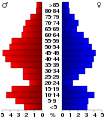 USA Custer County, Idaho age pyramid.svg 520 × 600; 8 KB
-
 View from Fishhook Creek Meadow.jpg 3.648 × 2.736; 3,23 MB
-
 Vishwanath in the perfect spot at just the right time.jpg 1.464 × 969; 889 KB
-
 Wildflowers in SNRA 1.JPG 2.816 × 2.112; 3,08 MB
-
 Wildflowers in SNRA 2.JPG 2.816 × 2.112; 3,9 MB
-
 Williams Peak 1.JPG 2.816 × 2.112; 960 KB
-
 Williams Peak 2.JPG 2.816 × 2.112; 1,51 MB
-
 Williams Peak 3.JPG 2.816 × 2.112; 4,51 MB
-
 Williams Peak 4.JPG 2.816 × 2.112; 1,88 MB
-
 Williams Peak Idaho.JPG 3.648 × 2.736; 5,09 MB
-
 Williams Peak Memorial Day 2012.jpg 3.456 × 5.184; 11,38 MB
-
 Williams Peak.JPG 2.816 × 2.112; 3,3 MB
-
 Yankeefork.JPG 1.024 × 768; 238 KB
-
 Yankeeforkstamp.JPG 768 × 1.024; 261 KB
-
 Yankeeforkstamp.jpg 740 × 989; 292 KB
-
 Yarrow SNRA.JPG 2.048 × 1.536; 2,63 MB
-
 Yellow bell SNRA.JPG 2.048 × 1.536; 2,64 MB
.jpg)
.jpg)
.jpg)
.jpg)
.jpeg)


.jpg)
.jpg)
.jpg)
.jpg)
.jpg)


.jpg)
.jpg)


.jpg)
.jpg)


,_Lost_River_Range,_Idaho_-_panoramio.jpg)
.jpg)


.jpg)


.jpg)
.jpg)
.jpg)
.jpg)


.jpg)


.jpg)
.jpg)
.jpg)
.jpg)
.jpg)


.jpeg)


.jpg)


.jpg)


.jpg)


.jpg)
.jpg)
.jpg)
.jpg)
.jpg)
.jpg)
.jpg)